Hässleholm Municipality
| Hässleholm Municipality Hässleholms kommun | ||
|---|---|---|
| Municipality | ||
| ||
 | ||
| Country | Sweden | |
| County | Skåne County | |
| Seat | Hässleholm | |
| Area[1] | ||
| • Total | 1,306.27 km2 (504.35 sq mi) | |
| • Land | 1,268.53 km2 (489.78 sq mi) | |
| • Water | 37.74 km2 (14.57 sq mi) | |
| Area as of January 1, 2014. | ||
| Population (June 30, 2016)[2] | ||
| • Total | 51,178 | |
| • Density | 39/km2 (100/sq mi) | |
| Time zone | CET (UTC+1) | |
| • Summer (DST) | CEST (UTC+2) | |
| ISO 3166 code | SE | |
| Province | Scania | |
| Municipal code | 1293 | |
| Website | www.hassleholm.se | |
Hässleholm Municipality (Hässleholms kommun) is a municipality in Skåne County in southern Sweden. Its seat is located in the city Hässleholm.
The present municipality was created in 1974 when the former City of Hässleholm (itself incorporated in 1914) was amalgamated with seven surrounding municipalities. Back in 1863 there were twenty-nine local government units (all rural) in the area.
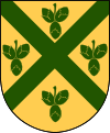
The municipal coat of arms was granted in 1920 and registered for the new municipality in 1974. The cross symbolizes the railway junction, which is the origin of the town Hässleholm. The hazelnuts allude to the name Hässleholm, which roughly translates as "Hazel-isle".
At 1,306.27 km2 Hässleholm is the second largest municipality in Skåne County by total area. By land area Hässleholm is the largest in Skåne County with 1,268.53 km2 (Kristianstad Municipality short after with 1,246.25 km2), much due to its relatively small water area of 37.74 km2.
Localities
There are 17 urban areas (also called a Tätort or locality) in Hässleholm Municipality.
In the table the localities are listed according to the size of the population as of December 31, 2005. The municipal seat is in bold characters.
| # | Locality | Population |
|---|---|---|
| 1 | Hässleholm | 17,730 |
| 2 | Tyringe | 4,573 |
| 3 | Vinslöv | 3,865 |
| 4 | Bjärnum | 2,643 |
| 5 | Sösdala | 1,785 |
| 6 | Vittsjö | 1,691 |
| 7 | Hästveda | 1,682 |
| 8 | Tormestorp | 1,045 |
| 9 | Stoby | 736 |
| 10 | Sjörröd | 672 |
| 11 | Finja | 553 |
| 12 | Vankiva | 363 |
| 13 | Ballingslöv | 321 |
| 14 | Emmaljunga | 291 |
| 15 | Röke | 243 |
| 16 | Mala | 228 |
| 17 | Västra Torup | 210 |
Industry
- Hässleholms Workshops
- Göinge Mechanical Workshop
- Hässleholms Brewery
- Hässleholms Kapsyl- och Stanniolfabrik
- Hässleholms Filfabrik
Sport in Hässleholm
Twin towns
Notable residents
|
|
References
- ↑ "Statistiska centralbyrån, Kommunarealer den 1 januari 2014" (Microsoft Excel) (in Swedish). Statistics Sweden. Retrieved 2014-04-18.
- ↑ "Folkmängd i riket, län och kommuner 30 juni 2016" (in Swedish). Statistics Sweden. August 17, 2016. Retrieved August 17, 2016.
External links
- Hässleholm Municipality - Official site
Municipalities and seats of Skåne County | ||
|---|---|---|
| Municipalities | ||
| Municipal seats | ||
Coordinates: 56°10′N 13°46′E / 56.167°N 13.767°E