Subdivisions of São Paulo
The city of São Paulo in Brazil is a large metropolitan city that has several levels of subdivision. Administratively, the municipality is divided into 31 subprefectures, each in turn divided into 96 districts. Locally, districts may contain one or more neighborhoods (bairros).
Administrative Zones
The subprefectures are officially grouped into nine regions (or "zones"), taking into account their geographical position and history of occupation. These regions are used only in technical and governmental agencies and are not identified by any visual communication in the city.
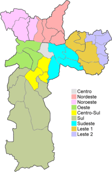
Administrative Zones of São Paulo | ||
| Zone | Population | Area |
| est. 2008 | in km² | |
| Central | 328,597 | 31 |
| Northwest | 1,007,691 | 144 |
| Northeast | 1,181,582 | 152 |
| East 1 | 1,212,099 | 140 |
| East 2 | 1,342,924 | 68,8 |
| Southeast | 1,494,770 | 128 |
| South | 2,346,913 | 607 |
| South-Central | 715,910 | 74 |
| West | 872,817 | 128 |
| 10,940,311 | 1509 | |
| Source:[1] | ||
Subprefectures
Subprefectures are similar to the boroughs of New York City and London. Subprefectures were created—at least in theory—to give more financial autonomy to local governments. There are 31 subprefectures.
| Subprefectures | ||||
|---|---|---|---|---|
| 1 | Aricanduva | 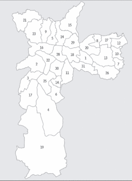 |
17 | M'Boi Mirim |
| 2 | Butantã | 18 | Mooca | |
| 3 | Campo Limpo | 19 | Parelheiros | |
| 4 | Capela do Socorro | 20 | Penha | |
| 5 | Casa Verde | 21 | Perus | |
| 6 | Cidade Ademar | 22 | Pinheiros | |
| 7 | Cidade Tiradentes | 23 | Pirituba-Jaraguá | |
| 8 | Ermelino Matarazzo | 24 | Santana-Tucuruvi | |
| 9 | Freguesia-Brasilândia | 25 | Santo Amaro | |
| 10 | Guaianases | 26 | São Mateus | |
| 11 | Ipiranga | 27 | São Miguel Paulista | |
| 12 | Itaim Paulista | 28 | Sé | |
| 13 | Itaquera | 29 | Vila Maria-Vila Guilherme | |
| 14 | Jabaquara | 30 | Vila Mariana | |
| 15 | Jaçanã-Tremembé | 31 | Vila Prudente | |
| 16 | Lapa | |||
Districts
Districts are smaller areas within the subprefecture.

Neighborhoods
Some districts are further divided into bairros, which are the equivalent of neighborhoods in English.
Geographic Areas
The city of São Paulo recognizes ten geographical areas used to reference locations in the city. These zones were established by dividing the city radially from the center and each is represented by a different color that is used on city buses and street signs. It should be noted, however, that the only criterion used for this division is geographic boundaries (roads, rivers, etc.), having no relation whatsoever to the administrative divisions. Some districts can be partly in one geographic area, and partly in another.
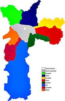
Geographic Areas of São Paulo |
| Historical Center |
| Expanded Center |
| Northwest |
| North |
| East |
| Northeast |
| Southeast |
| South |
| Southwest |
| West |