Tamarac, Florida
| Tamarac, Florida | |||||
|---|---|---|---|---|---|
| City | |||||
| City of Tamarac | |||||
| |||||
| Motto: "The City For Your Life!"[1] | |||||
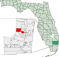 Location of Tamarac, Broward County, Florida | |||||
| Coordinates: 26°12′45″N 80°15′00″W / 26.21250°N 80.25000°WCoordinates: 26°12′45″N 80°15′00″W / 26.21250°N 80.25000°W | |||||
| Country |
| ||||
| State |
| ||||
| County |
| ||||
| Incorporated | August 15, 1963[2] | ||||
| Government | |||||
| • Type | Commission-Manager | ||||
| • Mayor | Harry Dressler | ||||
| • Vice Mayor | Pamela Bushnell | ||||
| • Commissioners | Michelle Gomez, Diane Glasser, and Debra Placko | ||||
| • City Manager | Michael C. Cernech | ||||
| • City Clerk | Pat Teufel | ||||
| Area[3] | |||||
| • City | 12.1 sq mi (31.3 km2) | ||||
| • Land | 11.6 sq mi (30.1 km2) | ||||
| • Water | 0.5 sq mi (1.2 km2) | ||||
| Elevation | 9 ft (3 m) | ||||
| Population (2010) | |||||
| • City | 60,427 | ||||
| • Density | 5,201/sq mi (2,008.3/km2) | ||||
| • Metro | 5,564,635 | ||||
| Time zone | Eastern (EST) (UTC-5) | ||||
| • Summer (DST) | EDT (UTC-4) | ||||
| ZIP code | 33309, 33319, 33320, 33321, 33351, 33359 | ||||
| Area code(s) | 954, 754 | ||||
| FIPS code | 12-70675[4] | ||||
| GNIS feature ID | 0300337[5] | ||||
| Website |
www | ||||


Tamarac is a city in Broward County, Florida, United States. As of the 2010 United States Census, the city had a population of 60,427.[3] It is part of the Miami–Fort Lauderdale–Pompano Beach Metropolitan Statistical Area, which was home to 5,564,635 people according to the 2010 census.
History
.png)
In the early 1960s a young developer named Ken Behring came from the Midwest and bought land where he could, creating an active adult community of two-bedroom maintenance-free homes. He called his new city Tamarac, named after the nearby Tamarac Country Club in Oakland Park.
In 1963, Behring built the city's first development east of State Road 7, Tamarac Lakes Section One and Section Two. Next came two neighborhoods of homes built on a former orange grove called Tamarac Lakes North and The Boulevards. Four of Behring's last developments were Tamarac Lakes South, then the Mainlands of Tamarac Lakes just west of State Road 7, and finally the Woodlands community.[6]
The city's early leaders, hoping to preserve Tamarac as a bedroom community, allowed Fort Lauderdale to annex commercial pockets, forever losing land that might have bolstered the city's coffers. In the late 1970s, the city de-annexed a long line of commercial buildings from State Road 7 all the way to Northwest 31 Avenue, but it went along with Behring's vision of Tamarac as a bedroom community. The boundaries were wherever Behring decided to build homes. The city's current eastern boundaries narrow to a sliver from Northwest 31 to 37 Avenues, then widen to the south. The city's easternmost boundary extends below Commercial Boulevard to Northwest 16 Avenue.
Behring also named a subdivision he founded in the Pinellas Park area, the "Mainlands of Tamarac By-the-Gulf".
Geography
Tamarac is located at 26°12′13″N 80°14′47″W / 26.20361°N 80.24639°W (26.203581, -80.246376).[7] According to the United States Census Bureau, the city has a total area of 12.1 square miles (31.3 km2), of which 11.6 square miles (30.1 km2) is land and 0.46 square miles (1.2 km2) is water (3.92%).[3]
Demographics
| Historical population | |||
|---|---|---|---|
| Census | Pop. | %± | |
| 1970 | 5,193 | — | |
| 1980 | 29,376 | 465.7% | |
| 1990 | 44,822 | 52.6% | |
| 2000 | 55,588 | 24.0% | |
| 2010 | 60,427 | 8.7% | |
| Est. 2015 | 64,681 | [8] | 7.0% |
| Tamarac Demographics | |||
|---|---|---|---|
| 2010 Census | Tamarac | Broward County | Florida |
| Total population | 60,427 | 1,748,066 | 18,801,310 |
| Population, percent change, 2000 to 2010 | +8.7% | +7.7% | +17.6% |
| Population density | 5,201.4/sq mi | 1,444.9/sq mi | 350.6/sq mi |
| White or Caucasian (including White Hispanic) | 67.2% | 63.1% | 75.0% |
| (Non-Hispanic White or Caucasian) | 49.0% | 43.5% | 57.9% |
| Black or African-American | 23.1% | 26.7% | 16.0% |
| Hispanic or Latino (of any race) | 24.3% | 25.1% | 22.5% |
| Asian | 2.5% | 3.2% | 2.4% |
| Native American or Native Alaskan | 0.2% | 0.3% | 0.4% |
| Pacific Islander or Native Hawaiian | 0.0% | 0.1% | 0.1% |
| Two or more races (Multiracial) | 2.8% | 2.9% | 2.5% |
| Some Other Race | 4.2% | 3.7% | 3.6% |
As of 2010, there were 32,794 households, with 13.4% being vacant. In 2000, 15.4% had children under the age of 18 living with them, 44.8% were married couples living together, 9.4% had a female householder with no husband present, and 42.6% were non-families. 36.3% of all households were made up of individuals and 23.0% had someone living alone who was 65 years of age or older. The average household size was 2.00 and the average family size was 2.56.
In 2000, the city the population was spread out with 13.4% under the age of 18, 5.3% from 18 to 24, 23.5% from 25 to 44, 20.1% from 45 to 64, and 37.8% who were 65 years of age or older. The median age was 53 years. For every 100 females there were 80.9 males. For every 100 females age 18 and over, there were 77.3 males.
In 2000, the median income for a household in the city was $34,290, and the median income for a family was $41,927. Males had a median income of $32,317 versus $28,360 for females. The per capita income for the city was $22,243. About 6.1% of families and 8.9% of the population were below the poverty line, including 13.5% of those under age 18 and 7.2% of those age 65 or over.
As of 2000, speakers of English language as a first language were at 78.08% of the population, while Spanish was at 13.69%. Also, Yiddish was at 1.90%, French at 1.15%, Haitian Creole consisted of 1.12%, Italian made up 1.08%, German comprised 0.62%, and Hebrew as a mother tongue made up 0.52% of residents.[10]
Over the years, the multicultural population has expanded in Tamarac, such as people from Latin American and Caribbean ancestry. As of 2000, Tamarac was the fifty-first-most Colombian-populated area in the U.S., with 2.74% of the population.[11] It also had the thirty-second-highest percentage of Jamaicans in the U.S., (tied with Royal Palm Beach and Goulds) at 4.1% of all residents.[12]
References
- ↑ "Tamarac Florida Official Website". Tamarac Florida Official Website. Retrieved September 19, 2012.
- ↑ "Broward-by-the-Numbers (pages 3-5)" (PDF). www.broward.org. Retrieved 2015-06-25.
- 1 2 3 "Geographic Identifiers: 2010 Demographic Profile Data (G001): Tamarac city, Florida". U.S. Census Bureau, American Factfinder. Retrieved October 23, 2013.
- ↑ "American FactFinder". United States Census Bureau. Retrieved 2008-01-31.
- ↑ "US Board on Geographic Names". United States Geological Survey. 2007-10-25. Retrieved 2008-01-31.
- ↑ "Tamarac Florida Official Website". Tamarac Florida Official Website. Retrieved September 19, 2012.
- ↑ "US Gazetteer files: 2010, 2000, and 1990". United States Census Bureau. 2011-02-12. Retrieved 2011-04-23.
- ↑ "Annual Estimates of the Resident Population for Incorporated Places: April 1, 2010 to July 1, 2015". Retrieved July 2, 2016.
- ↑ "Census of Population and Housing". Census.gov. Retrieved June 4, 2015.
- ↑ "Tamarac, Florida". Modern Language Association. Retrieved 2007-07-23.
- ↑ "Ancestry Map of Colombian Communities". Epodunk.com. Retrieved 2007-10-22.
- ↑ "Ancestry Map of Jamaican Communities". Epodunk.com. Retrieved 2007-10-22.
External links
| Wikimedia Commons has media related to Tamarac, Florida. |
- Official website
- Tamarac, Florida at City-Data.com
- Tamarac Historical Society
Municipalities and communities of Broward County, Florida, United States | ||
|---|---|---|
| Cities |  | |
| Towns | ||
| Villages | ||
| CDPs | ||
| Unincorporated community | ||
| Indian reservations | ||
| Ghost town | ||