Thoroughfare Gap Battlefield
|
Thoroughfare Gap Battlefield | |
|
Historical marker, with Beverly Mill in the background | |
   | |
| Location | Junction of Interstate 66 and State Route 55, Broad Run, Virginia |
|---|---|
| Coordinates | 38°49′30″N 77°42′47″W / 38.82500°N 77.71306°WCoordinates: 38°49′30″N 77°42′47″W / 38.82500°N 77.71306°W |
| Area | 514 acres (208 ha) |
| Built | 1862 |
| Architectural style | Federal, Mid 19th Century Revival |
| NRHP Reference # | 99001374[1] |
| VLR # | 030-1016 |
| Significant dates | |
| Added to NRHP | November 18, 1999 |
| Designated VLR | June 16, 1999[2] |
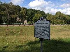
Thoroughfare Gap Battlefield is a historic American Civil War battlefield located at Thoroughfare Gap, Broad Run, Prince William County, Virginia. It was the site of the Battle of Thoroughfare Gap. The property includes a number of resources present at the time of the battle including the separately listed Beverley Mill, a five-story, coursed-rubble stone building set into the north side of Thoroughfare Gap. Meadowlands, the Chapman's house and the second Upper Mill are clearly visible on the landscape, as well as an important ice pit and a walled cemetery associated with the Chapman family.[3]
It was listed on the National Register of Historic Places in 1999.[1]
References
- 1 2 National Park Service (2010-07-09). "National Register Information System". National Register of Historic Places. National Park Service.
- ↑ "Virginia Landmarks Register". Virginia Department of Historic Resources. Retrieved 5 June 2013.
- ↑ Deidre McCarthy and W. Brown Morton III (February 1999). "National Register of Historic Places Inventory/Nomination: Thoroughfare Gap Battlefield" (PDF). Virginia Department of Historic Resources. and Accompanying three photos
External links
- Meadowland (Ruins), State Route 55, near Beverley's Mill, Haymarket, Prince William County, VA: 1 photo at Historic American Buildings Survey


This article is issued from Wikipedia - version of the 11/30/2016. The text is available under the Creative Commons Attribution/Share Alike but additional terms may apply for the media files.