Waldighofen
| Waldighofen Wàldighoffe | ||
|---|---|---|
| ||
 Waldighofen | ||
|
Location within Grand Est region  Waldighofen | ||
| Coordinates: 47°33′05″N 7°19′03″E / 47.5514°N 7.3175°ECoordinates: 47°33′05″N 7°19′03″E / 47.5514°N 7.3175°E | ||
| Country | France | |
| Region | Grand Est | |
| Department | Haut-Rhin | |
| Arrondissement | Altkirch | |
| Canton | Hirsingue | |
| Intercommunality | Ill et Gersbach | |
| Government | ||
| • Mayor (1989–2012) | Henri Hoff | |
| Area1 | 4.14 km2 (1.60 sq mi) | |
| Population (2006)2 | 1,398 | |
| • Density | 340/km2 (870/sq mi) | |
| Time zone | CET (UTC+1) | |
| • Summer (DST) | CEST (UTC+2) | |
| INSEE/Postal code | 68355 / 68640 | |
| Elevation |
342–446 m (1,122–1,463 ft) (avg. 357 m or 1,171 ft) | |
|
1 French Land Register data, which excludes lakes, ponds, glaciers > 1 km² (0.386 sq mi or 247 acres) and river estuaries. 2 Population without double counting: residents of multiple communes (e.g., students and military personnel) only counted once. | ||
.svg.png)
Waldighofen (Alemannic German: Wàldighoffe) is a commune in the Haut-Rhin department in Alsace in north-eastern France.
 Peter and Paul Church
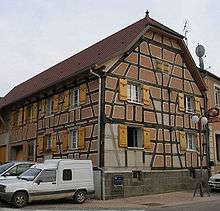 Birthplace of Nathan Katz
 Street sign with Alsatian name
See also
References
| Wikimedia Commons has media related to Waldighofen. |
This article is issued from Wikipedia - version of the 7/7/2015. The text is available under the Creative Commons Attribution/Share Alike but additional terms may apply for the media files.