Walker, Kansas
| Walker, Kansas | |
|---|---|
| Unincorporated community | |
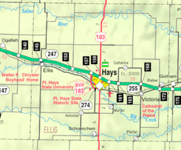 KDOT map of Ellis County (legend) | |
 Walker  Walker | |
| Coordinates: 38°52′02″N 99°04′33″W / 38.86722°N 99.07583°WCoordinates: 38°52′02″N 99°04′33″W / 38.86722°N 99.07583°W | |
| Country | United States |
| State | Kansas |
| County | Ellis |
| Founded | 1872 |
| Elevation | 1,942 ft (592 m) |
| Time zone | Central (CST) (UTC-6) |
| • Summer (DST) | CDT (UTC-5) |
| ZIP code | 67674 |
| Area code(s) | 785 |
| GNIS feature ID | 475301[1] |
Walker is an unincorporated community in Herzog Township, Ellis County, Kansas, United States.[2] Walker has a post office with ZIP code 67674.[3]
History
Settlers from Ohio founded Walker in 1872.[4] They likely named the settlement for Robert J. Walker, the 4th Territorial Governor of Kansas.[5] From 1876 to 1878, they were joined by Volga German immigrants and Plattdeutsch-speaking Germans from Ohio and Kentucky who settled in the area.[4]
The first post office in Walker opened in 1873, closed temporarily in 1876, and then reopened in 1878.[6] St. Ann's Church was built and dedicated in 1905. The community's first school was built in 1893, followed by a second building in 1925. The school has since closed but remains in use as a community center.[4]
In 1942, the U.S. Army built Walker Army Airfield one mile northwest of Walker. During World War II, thousands were stationed at the airfield, mostly for training in operation of the Boeing B-29 Superfortress bomber aircraft. The military closed the base in 1946.[7]
Construction of Interstate 70 reached Walker in 1966, passing immediately south of the community.
Geography
Walker is located at 38°52′02″N 99°04′33″W / 38.86722°N 99.07583°W (38.8672339, -99.0759271) at an elevation of 1,942 feet (592 m).[1] It lies approximately 1.5 miles (2.3 km) west of Walker Creek, part of the Smoky Hill River watershed, in the Smoky Hills region of the Great Plains.[8][9] Walker is immediately north of Interstate 70 roughly 13 miles (21 km) east of Hays, the county seat.[9]
Transportation
Walker Avenue, a paved county road, runs north-south through Walker, intersecting Interstate 70 and U.S. Route 40, which run concurrently east-west, immediately south of town.[9] The old alignment of U.S. 40, now a paved county road, runs northeast-southwest through Walker.[10]
The Kansas Pacific (KP) line of the Union Pacific Railroad runs northeast-southwest through Walker, parallel to the old alignment of U.S. 40.[9][11]
See also
- Walker Army Airfield, an abandoned World War II airfield.
References
- 1 2 "US Board on Geographic Names". United States Geological Survey. 2007-10-25. Retrieved 2008-01-31.
- ↑ "General Highway Map - Ellis County, Kansas" (PDF). Kansas Department of Transportation. 1978. Retrieved 2010-12-18.
- ↑ ZIP Code Lookup
- 1 2 3 "Ellis County". Kansas Heritage Project. Fort Hays State University. Retrieved 2014-10-27.
- ↑ Heim, Michael (2007). Exploring Kansas Highways. p. 33.
- ↑ "Kansas Post Offices, 1828-1961 (archived)". Kansas Historical Society. Archived from the original on October 9, 2013. Retrieved 9 June 2014.
- ↑ "U.S. Army and Air Force Wings Over Kansas". Kansas Historical Quarterly. Kansas State Historical Society. 25 (1): 334–360. Spring 1959.
- ↑ "2003-2004 Official Transportation Map" (PDF). Kansas Department of Transportation. 2003. Retrieved 2010-12-18.
- 1 2 3 4 "General Highway Map - Ellis County, Kansas" (PDF). Kansas Department of Transportation. 2010-06-01. Retrieved 2010-12-18.
- ↑ "Official 1960-61 Kansas Highway Map" (PDF). Kansas Department of Transportation. Retrieved 2010-12-18.
- ↑ "UPRR Common Line Names" (PDF). Union Pacific Railroad. Retrieved 2010-10-10.
External links
Municipalities and communities of Ellis County, Kansas, United States | ||
|---|---|---|
| Cities | 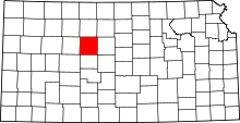 | |
| CDPs | ||
| Unincorporated communities | ||
| Ghost towns | ||
| Townships | ||