Yocemento, Kansas
| Yocemento, Kansas | |
|---|---|
| Unincorporated community | |
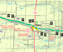 KDOT map of Ellis County (legend) | |
 Yocemento  Yocemento | |
| Coordinates: 38°54′26″N 99°25′26″W / 38.90722°N 99.42389°WCoordinates: 38°54′26″N 99°25′26″W / 38.90722°N 99.42389°W | |
| Country | United States |
| State | Kansas |
| County | Ellis |
| Township | Big Creek |
| Founded | 1906 |
| Elevation | 2,051 ft (625 m) |
| Time zone | CST (UTC-6) |
| • Summer (DST) | CDT (UTC-5) |
| ZIP code | 67601 |
| Area code | 785 |
| GNIS feature ID | 484723[1] |
Yocemento is an unincorporated community in Big Creek Township, Ellis County, Kansas, United States.[2]
History
The U.S. Portland Cement Company constructed a cement mill at the site of Yocemento in 1906.[3][4] In 1907, the company platted a town for the mill's workers, naming it Yocemento, a portmanteau of Yost, the company president's last name, and cement.[4][5] A post office opened that same year.[6] By mid-1908, the mill was operational, and the town included a general store, hotel, and restaurant. Many local residents employed at the mill were ethnic Hungarians who had constructed a Catholic church at the site in 1906.[4]
In 1917, the cement company went bankrupt and sold the mill to a Denver-based competitor.[4] The post office closed as well.[6] The mill was dismantled, and residents began to leave the community. In 1931, the church building was moved to Buckeye, Kansas for use as a community hall. Today, what remains of the mill has been remodeled into family homes.[4]
Geography
Yocemento is located at 38°54′26″N 99°25′26″W / 38.90722°N 99.42389°W (38.9072335, -99.4239958) at an elevation of 2,051 feet (625 m).[1] It is 1 mile (1.6 km) south of Interstate 70 and 5.5 miles (8.9 km) west-northwest of Hays, the county seat.[2]
Yocemento lies on the south side of Big Creek in the Smoky Hills region of the Great Plains.[2][7]
Transportation
The old alignment of U.S. Route 40, now a paved county road, runs southeast-northwest through Yocemento.[8] Another paved county road, Yocemento Avenue, runs generally north-south through the community, connecting to an interchange with Interstate 70 to the north.[9]
The Kansas Pacific (KP) line of the Union Pacific Railroad runs southeast-northwest through Yocemento, parallel to the old alignment of U.S. 40.[2][10]
References
- 1 2 "US Board on Geographic Names". United States Geological Survey. 2007-10-25. Retrieved 2015-07-13.
- 1 2 3 4 "General Highway Map - Ellis County, Kansas" (PDF). Kansas Department of Transportation. 1978. Retrieved 2015-07-13.
- ↑ "Yocemento". KSGenWeb. Retrieved 9 June 2014.
- 1 2 3 4 5 "Ellis County". Kansas Heritage Project. Fort Hays State University. Retrieved 2015-07-16.
- ↑ Heim, Michael (2007). Exploring Kansas Highways. p. 31.
- 1 2 "Kansas Post Offices, 1828-1961 (archived)". Kansas Historical Society. Archived from the original on October 9, 2013. Retrieved 9 June 2014.
- ↑ "2003-2004 Official Transportation Map" (PDF). Kansas Department of Transportation. 2003. Retrieved 2015-07-16.
- ↑ "Official 1960-61 Kansas Highway Map" (PDF). Kansas Department of Transportation. Retrieved 2015-07-16.
- ↑ "Yocemento, KS". Google Maps. Retrieved 2015-07-16.
- ↑ "UPRR Common Line Names" (PDF). Union Pacific Railroad. Retrieved 2015-07-16.
Municipalities and communities of Ellis County, Kansas, United States | ||
|---|---|---|
| Cities | 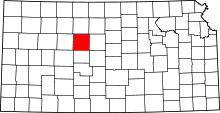 | |
| CDPs | ||
| Unincorporated communities | ||
| Ghost towns | ||
| Townships | ||