Zinc, Arkansas
| Zinc, Arkansas | |
|---|---|
| Town | |
 Location in Boone County and the state of Arkansas | |
| Coordinates: 36°17′7″N 92°54′56″W / 36.28528°N 92.91556°WCoordinates: 36°17′7″N 92°54′56″W / 36.28528°N 92.91556°W | |
| Country | United States |
| State | Arkansas |
| County | Boone |
| Area | |
| • Total | 0.7 sq mi (1.9 km2) |
| • Land | 0.7 sq mi (1.9 km2) |
| • Water | 0 sq mi (0 km2) |
| Elevation | 879 ft (268 m) |
| Population (2010) | |
| • Total | 103 |
| • Density | 108.6/sq mi (40/km2) |
| Time zone | Central (CST) (UTC-6) |
| • Summer (DST) | CDT (UTC-5) |
| ZIP code | 72601 |
| Area code(s) | 870 |
| FIPS code | 05-77600 |
| GNIS feature ID | 0058929 |
Zinc is a town in Boone County, Arkansas, United States. The population was 103 at the 2010 census. It is part of the Harrison Micropolitan Statistical Area.
History
Zinc mining gave the town its name.[1]
Geography
Zinc is located at 36°17′7″N 92°54′56″W / 36.28528°N 92.91556°W (36.285384, -92.915419).[2]
According to the United States Census Bureau, the town has a total area of 1.9 km² (0.8 mi²), all land.
Demographics
| Historical population | |||
|---|---|---|---|
| Census | Pop. | %± | |
| 1910 | 173 | — | |
| 1920 | 144 | −16.8% | |
| 1930 | 188 | 30.6% | |
| 1940 | 119 | −36.7% | |
| 1950 | 99 | −16.8% | |
| 1960 | 68 | −31.3% | |
| 1970 | 58 | −14.7% | |
| 1980 | 113 | 94.8% | |
| 1990 | 91 | −19.5% | |
| 2000 | 76 | −16.5% | |
| 2010 | 103 | 35.5% | |
| Est. 2015 | 104 | [3] | 1.0% |
As of the census[5] of 2010, there were 103 people, 37 households, and 23 families residing in the town. The population density was 39.1/km² (101.8/mi²). There were 35 housing units at an average density of 18.0/km² (46.9/mi²). The racial makeup of the town was 88.3% White, 1% Black or African American, and 8.7% from two or more races. 1.9% of the population were Hispanic or Latino of any race.
There were 37 households out of which 64.5% had children under the age of 18 living with them, 45.2% were married couples living together, 16.1% had a female householder with no husband present, and 22.6% were non-families. 19.4% of all households were made up of individuals and 3.2% had someone living alone who was 65 years of age or older. The average household size was 2.45 and the average family size was 2.79.
In the town the population was spread out with 18.4% under the age of 18, 6.6% from 18 to 24, 25.0% from 25 to 44, 38.2% from 45 to 64, and 11.8% who were 65 years of age or older. The median age was 45 years. For every 100 females there were 145.2 males. For every 100 females age 18 and over, there were 148.0 males.
The median income for a household in the town was $20,036, and the median income for a family was $18,250. Males had a median income of $10,194 versus $5,250 for females. The per capita income for the town was $9,999. There were 35.8% of families and 25.9% of the population living below the poverty line, including 43.0% of under eighteens and 63.7% of those over 64.

School district
Zinc, along with Bergman, is within the Bergman School District.[6]
References
- ↑ "Colorful Names". Arkansas Department of Parks & Tourism. Archived from the original on November 24, 2013. Retrieved 14 July 2014.
- ↑ "US Gazetteer files: 2010, 2000, and 1990". United States Census Bureau. 2011-02-12. Retrieved 2011-04-23.
- ↑ "Annual Estimates of the Resident Population for Incorporated Places: April 1, 2010 to July 1, 2015". Retrieved July 2, 2016.
- ↑ "Census of Population and Housing". Census.gov. Archived from the original on May 11, 2015. Retrieved June 4, 2015.
- ↑ "American FactFinder". United States Census Bureau. Archived from the original on September 11, 2013. Retrieved 2008-01-31.
- ↑ School District Reference Map (2010 Census): Boone County, AR (PDF) (Map). US Census Bureau. Retrieved 20110628. Check date values in:
|access-date=(help)
External links
- Map of Zinc (US Census Bureau)
- Boone County Historical and Railroad Society, Inc.
- Bergman School District
- Town government information
- Detailed 2000 US Census statistics
- Boone County School District Reference Map (US Census Bureau, 2010)
Municipalities and communities of Boone County, Arkansas, United States | ||
|---|---|---|
| Cities | 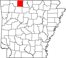 | |
| Towns | ||
| Townships | ||
| Unincorporated communities | ||
| Ghost town | ||
| Footnotes | ‡This populated place also has portions in an adjacent county or counties | |