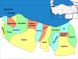
Çaykara
| Çaykara | |
|---|---|
 Çaykara | |
| Coordinates: 40°44′51″N 40°14′31″E / 40.74750°N 40.24194°ECoordinates: 40°44′51″N 40°14′31″E / 40.74750°N 40.24194°E | |
| Country | Turkey |
| Province | Trabzon |
| Government | |
| • Mayor | Hanefi Tok (AKP) |
| Area[1] | |
| • District | 573.14 km2 (221.29 sq mi) |
| Population (2012)[2] | |
| • Urban | 2,000 |
| • District | 13,220 |
| • District density | 23/km2 (60/sq mi) |
| Climate | Cfa |
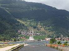
Çaykara is a town and district of Trabzon Province in the Black Sea region of Turkey. As of 2014, the District Mayor of Çaykara is Hanefi Tok (AKP). Çaykara lies in a V-shaped valley along the Solaklı River in the Pontic Mountains, at an elevation of around 300 metres.
Etymology

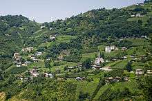
The district takes its name from the Çaykara stream, which forms through the conjunction of the Solaklı and Yeşilalan brooks. The historic name of Çaykara is Kadahor (from Kato Choriou "lower village" in Pontic Greek).[3] As is typical in transhumance communities in the Pontic Mountains and the Caucasus, Kadahor was settled with a number of subordinate upland villages for different seasons, which explains its name.
History
Çaykara entered Ottoman rule in 1461, following the Ottoman conquest of the Empire of Trebizond by Sultan Mehmed II.
According to the Ottoman tax books (tahrir defterleri) of 1486, there were 1277 people living in the historic villages that were located within the present-day Çaykara district (namely the villages of Ğorğoras (in Greek: Γοργορά), Holayisa, Paçan and Zeno (in Greek: Ξένος), where there were 235 houses (1 of them inhabited by Muslims, 234 of them by Christians.)[4]
According to the Ottoman tax books (tahrir defterleri) of 1681, the inhabitants of the villages of Ğorğoras, Holayisa, Paçan, Zeno, Yente, Haldizen, İpsil (in Greek: Υψηλή), Okene, Sero (Siros), Kadahor, Hopşera, Sarahos (in Greek: Σαχάρω), Fotinos (in Greek: Φωτεινός) and Zeleka had been fully converted to Islam.[4] In 1681, there were 2100 people living in 380 houses, all of them Muslims.[4] Because of their Islamic identity, the inhabitants of Kadahor/Çaykara were not deported during the population exchange between Greece and Turkey in 1923. A few dozen families from the valley that had retained their Christian beliefs chose to resettle in Macedonia, Greece, in de village of Nea Trapezounta (New Trabzon).
The mother tongue of most inhabitants of the district is the Of-dialect of Pontic Greek, colloquially called Romeyka (i.e. 'language of the Romans'). There are about two dozen Grecophone villages in the district, making it the largest concentration of Greek speakers in the Turkish Republic. Inhabitants from Of and Çaykara also settled villages in neighboring Sürmene district and in Tonya, a little further to the west. Thus there are also some pockets of Çaykara/Of-dialect Greek speaking villages in these other parts of Trabzon province. That the Of-dialect of Pontic Greek remains so virulent in this sparsely populated area is partly due to the fact that local imams educated and preached in this language until the second part of the 20th century. The villages in the Of-valley provided education to many poor students from the wider region and even Anatolia during the Ottoman era. This history of literacy is reflected in the many scientists, politicians, musicians, directors, etc. that came from the sparsely populated villages in the district.
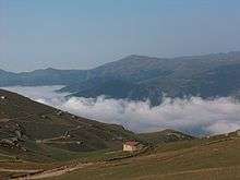
The Sultan Murat Plateau (Turkish: Sultan Murat Yaylası 40°40′12″N 40°10′13″E / 40.67000°N 40.17028°E) is a high plateau 25 km (16 mi) southwest of Çaykara's town center. In 1915, during the Caucasus Campaign of World War I, the Ottoman Army fought the invading Russian troops at this plateau. A monumental cemetery for the fallen Ottoman soldiers, named Şehitler Tepesi (Hill of Martyrs) is located there.
Until 1925, Çaykara was a village bound to the Of district within Trabzon Province. In 1925, it became a bucak (subdistrict), and on 1 June 1947 it became an ilçe (district) of Trabzon Province.
Notable residents
- Cevdet Sunay (1899), Fifth president of Turkey
- Behram Kurşunoğlu (1922), physicist
- Orhan Tekeoğlu (1957), film director
- Yeşim Ustaoğlu (1960), architect and film director
- Yunus Vehbi Yavuz (1944) professor, academician, author
- Yusuf Şevki Yavuz (1953) professor, academician, author
- Salih Sabri Yavuz (1962) professor, academician, author
- Hasan Rami Yavuz (1909) scholar and lecturer, author
- Kemal Yazıcıoğlu (1941) Bureaucrat, governor
- Osman Turan (1914) Professor, politician
- Ali Rıza Uzuner (1926) Bureaucrat, ex-minister of labour
- Ismail Müftüoğlu (1939) Bureaucrat, ex-minister of justice
- A.Atilla Osmançelebioğlu (1947) Bureaucrat, governor
- Nusret Miroğlu (1947) Bureaucrat, governor
- Murat Mollamahmutoğlu (1959) professor, academician
- Seyfullah Hacımüftüoğlu (1960) Bureaucrat, governor
- Sebahattin Öztürk (1962) Bureaucrat, governor
- Ulvi Saran (1958) Bureaucrat, academician, governor
- Mevlüt Bilici (1961) Bureaucrat, governor
- Ismail Yüksek (1941) professor, academician, rector
- Hikmet Öksüz (1965) professor, academician
- Bekir Topaloğlu (1936) professor, academician, author
- Yaşar Yazıcıoğlu (???) Bureaucrat, politician, author
- Devlet Toksoy (1967) professor, academician
- Ali Fikri Yavuz (1924) scholar, author
- Eyüp Aşık (1953) politician, ex-parliamenter
- Ibrahim Cevahir (1938) businessman
- Atasoy Müftüoğlu (1942) researcher, author, thinker
- Erol Zihni Gürsoy (1955) bureaucrat, governor
- Ahmet Cemil Kara (1924) politician, ex-parliamenter
- Ali Naci Tuncer (1939) bureaucrat, ex-parliamenter
- Ayşe Doğan (1952) judge, member of supreme court
- Kerim Aydın (1953) musician,
- Mazhar Afacan (1940) businessmen, sportsman
- Mehmet Gedik (1953) politician, ex-parliamenter
- Mehmet Kara (1939) politician, ex-soldier
- Mehmet Zekai Özcan (1950) bureaucrat, politician
- Murat Bölükbaş (1980) professional football player
- Ümit Teke (1980) professional football player
- Zafer Cansız (1987) professional football player
- Ismail Yüksek (1963) scholar, academician, professor
- Ismail Inan (1918) politician, labour unionist
Mehmet Niyazoglu (1935) businessman, builder of Izmir Bus Terminal
Ahmet Cemal Niyazoglu (1944) theologist, researcher, author
See also
- Trabzon Province
- Trabzon
- Uzungöl
- Pontic Mountains
- Sultanmurat Plateau
References
- ↑ "Area of regions (including lakes), km²". Regional Statistics Database. Turkish Statistical Institute. 2002. Retrieved 2013-03-05.
- ↑ "Population of province/district centers and towns/villages by districts - 2012". Address Based Population Registration System (ABPRS) Database. Turkish Statistical Institute. Retrieved 2013-02-27.
- ↑ Karadeniz Ansiklopedik Sözlük: "Kadahor", by Özkan Öztürk. Istanbul, 2005.
- 1 2 3 History of Çaykara
External links
- Çaykara district governor's official website (Turkish)
- Uzungöl Website
- Images of the Sultan Murat Plateau