Ørskog
| Ørskog kommune | |||
|---|---|---|---|
| Municipality | |||
 | |||
| |||
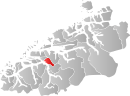 Ørskog within Møre og Romsdal | |||
| Coordinates: 62°28′44″N 06°53′07″E / 62.47889°N 6.88528°ECoordinates: 62°28′44″N 06°53′07″E / 62.47889°N 6.88528°E | |||
| Country | Norway | ||
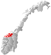
| County | Møre og Romsdal | ||
| District | Sunnmøre | ||
| Administrative centre | Sjøholt | ||
| Government | |||
| • Mayor (2007) | Thorbjørn Fylling (FrP) | ||
| Area | |||
| • Total | 132.30 km2 (51.08 sq mi) | ||
| • Land | 128.85 km2 (49.75 sq mi) | ||
| • Water | 3.45 km2 (1.33 sq mi) | ||
| Area rank | 368 in Norway | ||
| Population (2013) | |||
| • Total | 2,267 | ||
| • Rank | 335 in Norway | ||
| • Density | 17.6/km2 (46/sq mi) | ||
| • Change (10 years) | 9.3 % | ||
| Demonym(s) | Ørskogbygdar[1] | ||
| Time zone | CET (UTC+1) | ||
| • Summer (DST) | CEST (UTC+2) | ||
| ISO 3166 code | NO-1523 | ||
| Official language form | Nynorsk | ||
| Website |
www | ||
|
| |||
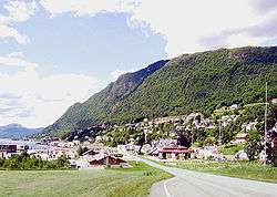
Ørskog is a municipality in Møre og Romsdal county, Norway. It is part of the Sunnmøre region. The administrative centre is the village of Sjøholt. The other main village is Vaksvika, about 7.5 kilometres (4.7 mi) south of Sjøholt. The European Route E39/E136 highway runs through the municipality, connecting the towns of Ålesund and Molde. Rauma Group is the largest company in Ørskog in terms of turnover.
General information
Ørskog was established as a municipality on 1 January 1838 (see formannskapsdistrikt). On 1 August 1883, the southwestern district of Ørskog (most of Ørskog on the southwestern side of the Storfjorden except for the Søvik and Ramstaddalen areas) was separated to form the new Søkelven Municipality. This left Ørskog with 1,735 inhabitants. On 1 June 1955, the Søvik and Ramstaddalen areas of Ørskog (south of the Storfjorden) were administratively transferred to Sykkylven Municipality. On 1 January 1965, Skodje Municipality (to the west) and Stordal Municipality (to the south) were merged into Ørskog to form a new, large Ørskog Municipality. This merger was not long-lived. On 1 January 1977, the three municipalities were separated again.[2]
Name
The municipality (originally the parish) is named after the old Ørskog farm (Old Norse: Øyraskógr), since the first church (Ørskog Church) was built there. The first element is the plural genitive case of øyrr which means "shoal" and the last element is skógr which means "wood" or "forest".[3]
Coat-of-arms
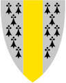
The coat-of-arms is from modern times. They were granted on 11 November 1983. The arms show a gold-colored wooden pole in the center with black and white ermine on each side of the pole. This was chosen as a symbol for forestry and fur farming. In the 17th century, the municipality exported many tall trees to the Dutch Republic, where they were used for shipbuilding. The ermine is a canting for the many animals in the forests.[4]
Churches
The Church of Norway has one parish (sokn) within the municipality of Ørskog. It is part of the Austre Sunnmøre deanery in the Diocese of Møre.
| Parish (Sokn) | Church Name | Location of the Church | Year Built |
|---|---|---|---|
| Ørskog | Ørskog Church | Sjøholt | 1873 |
Geography
The municipality lies on the north shore of the Storfjorden, and it is bordered by Skodje Municipality to the west, Vestnes Municipality to the north and east, and Stordal Municipality to the south. Most of the population lives along the shore or in the small valleys that stretch inland from the fjord. The eastern part of the municipality is mountainous.
References
- ↑ "Navn på steder og personer: Innbyggjarnamn" (in Norwegian). Språkrådet. Retrieved 2015-12-01.
- ↑ Jukvam, Dag (1999). "Historisk oversikt over endringer i kommune- og fylkesinndelingen" (PDF) (in Norwegian). Statistisk sentralbyrå.
- ↑ Rygh, Oluf (1908). Norske gaardnavne: Romsdals amt (in Norwegian) (13 ed.). Kristiania, Norge: W. C. Fabritius & sønners bogtrikkeri. p. 152.
- ↑ Norske Kommunevåpen (1990). "Nye kommunevåbener i Norden". Retrieved 19 October 2008.
External links
 Media related to Ørskog at Wikimedia Commons
 Møre og Romsdal travel guide from Wikivoyage