Midsund
| Midsund kommune | |||
|---|---|---|---|
| Municipality | |||
| |||
 Midsund within Møre og Romsdal | |||
| Coordinates: 62°42′31″N 06°47′48″E / 62.70861°N 6.79667°ECoordinates: 62°42′31″N 06°47′48″E / 62.70861°N 6.79667°E | |||
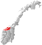
| Country | Norway | ||
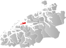
| County | Møre og Romsdal | ||
| District | Romsdal | ||
| Administrative centre | Midsund | ||
| Government | |||
| • Mayor (2011) | Einar Øien (FrP) | ||
| Area | |||
| • Total | 94.75 km2 (36.58 sq mi) | ||
| • Land | 93.99 km2 (36.29 sq mi) | ||
| • Water | 0.76 km2 (0.29 sq mi) | ||
| Area rank | 390 in Norway | ||
| Population (2013) | |||
| • Total | 2,010 | ||
| • Rank | 339 in Norway | ||
| • Density | 21.4/km2 (55/sq mi) | ||
| • Change (10 years) | +2.6 % | ||
| Demonym(s) |
Midsunding Midsundværing[1] | ||
| Time zone | CET (UTC+1) | ||
| • Summer (DST) | CEST (UTC+2) | ||
| ISO 3166 code | NO-1545 | ||
| Official language form | Nynorsk | ||
| Website |
www | ||
|
| |||

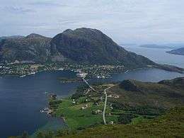
Midsund is a municipality in Møre og Romsdal county, Norway. It is part of the Romsdal region. The administrative centre is the village of Midsund on Otrøya island. Other settlements on the island include Uglvik and Raknes in the north and Nord-Heggdal in the southeast.
The municipality consists of many islands. The main islands are Otrøya, Midøya, and Dryna, as well as the smaller populated islands of Magerøya and Tautra—both are less than 1 square kilometre (250 acres). There are also many tiny uninhabited islands and skerries. The islands all sit at the mouth of the great Romsdalsfjorden.
General information
The municipality of Midsund was established on 1 January 1965 when the old municipality of Sør-Aukra (population: 1,912) was merged with part of Midøya island and the neighboring island of Dryna (population: 334) which were part of Vatne municipality.[2]
Name
The municipality is named after the strait that flows between the islands of Otrøya and Midøya, the Midsundet (Old Norse: Miðjusund). The first element of the name Miðja means "middle" and the second element sund means "strait" or "sound".[3]
Coat-of-arms
The coat-of-arms is from modern times. They were granted on 15 May 1987. The arms show two silver triangles on a blue background, representing Otrøya and Midøya islands in the ocean. These two main islands in the municipality are separated by a small strait, the Midsund. The geographical situation is symbolised in the arms.[4]
Churches
The Church of Norway has one parish (sokn) within the municipality of Midsund. It is part of the Molde arch-deanery in the Diocese of Møre.
| Parish (Sokn) | Church Name | Location of the Church | Year Built |
|---|---|---|---|
| Midsund | Otrøy Church | Uglvik, Otrøya | 1878 |
| Nord-Heggdal Chapel | Nord-Heggdal | 1974 |
Geography
The islands of Midsund Municipality are separated from the mainland by the 2-kilometre (1.2 mi) wide Julsundet to the east and the 3-kilometre (1.9 mi) wide Midfjorden to the south. To the north are many smaller islands including Gossa (in Aukra Municipality) and Harøya, Sandøya, and Orta (in Sandøy Municipality). To the west lie the islands of Fjørtofta, Skuløya, and Haramsøya (in Haram Municipality).
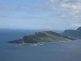
The three largest islands of the community lie in a line from ENE to WSW (Otrøya, Midøya, and Dryna). The island of Magerøya lies between Midøya and Otrøya and a bridge connects it to the latter. Tautra lies in the Moldefjorden, southeast of Otrøya. Otrøya is the main island of the community, measuring about 20 kilometres (12 mi) from east to west. The southern coasts of Otrøya, Midøya, and Dryna rise from the fjord as sheer 800-metre (2,600 ft) tall cliffs. At Oppstad, the cliff is feared to collapse, which would cause a small tsunami in the Moldefjorden.
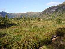
On the southern coast of Otrøya the following small villages can be found: (from east to west) Solholmen, Nord-Heggdal, Oppstad, Sør-Heggdal, and Klauset. The north has the following villages: (east to west) Ræstad, Rakvåg, Tangen, Raknes, and Uglvik. On the western side of Otrøya, facing the bay that separates it from Midøya, lies the village of Midsund, the largest settlement in the community. The Midsund Bridge connects it with Midøya. Dryna and Midøya are also connected with a bridge. Ferries run between the islands and the mainland. There is a ferry from Solholmen across the Julsundet to Molde Municipality and from the island of Dryna to the village of Brattvåg (in Haram Municipality). The larger three islands' interior is wilderness, but the rims are used for keeping cattle and small farming.
Demographics
The community has 1,939 inhabitants (January 2005), with 50.3% male. The percentage of people older than 67 is 18.3%. Unemployment is 2.3%. Population growth is stable. Most inhabitants are fishers or small farmers.
References
- ↑ "Navn på steder og personer: Innbyggjarnamn" (in Norwegian). Språkrådet. Retrieved 2015-12-01.
- ↑ Jukvam, Dag (1999). "Historisk oversikt over endringer i kommune- og fylkesinndelingen" (PDF) (in Norwegian). Statistisk sentralbyrå.
- ↑ Rygh, Oluf (1908). Norske gaardnavne: Romsdals amt (in Norwegian) (13 ed.). Kristiania, Norge: W. C. Fabritius & sønners bogtrikkeri. p. 307.
- ↑ Norske Kommunevåpen (1990). "Nye kommunevåbener i Norden". Retrieved 19 October 2008.