Airan
(typo
| Airan | |
|---|---|
|
Chateau of Coupigny | |
 Airan | |
|
Location within Normandy region  Airan | |
| Coordinates: 49°06′07″N 0°09′02″W / 49.1019°N 0.1506°WCoordinates: 49°06′07″N 0°09′02″W / 49.1019°N 0.1506°W | |
| Country | France |
| Region | Normandy |
| Department | Calvados |
| Arrondissement | Caen |
| Canton | Bouguébus |
| Intercommunality | Val ès dunes |
| Government | |
| • Mayor (2008–2020) | Patrice Martin |
| Area1 | 13.5 km2 (5.2 sq mi) |
| Population (2010)2 | 686 |
| • Density | 51/km2 (130/sq mi) |
| Time zone | CET (UTC+1) |
| • Summer (DST) | CEST (UTC+2) |
| INSEE/Postal code | 14005 / 14370 |
| Elevation |
22–64 m (72–210 ft) (avg. 30 m or 98 ft) |
|
1 French Land Register data, which excludes lakes, ponds, glaciers > 1 km² (0.386 sq mi or 247 acres) and river estuaries. 2 Population without double counting: residents of multiple communes (e.g., students and military personnel) only counted once. | |
Airan is a French commune in the Calvados department in the Normandy region of northwestern France.
The inhabitants of the commune are known as Airannais or Airannaises[1]
Geography
Airan is located some 17 km south-east of Caen and 25 km east by south-east of Lisieux. It can be accessed from the D40 from Vimont in the north-west, passing through the south of the commune and continuing south-east to Vieux-Fumé. The D613 (Route de Paris) also from Vimont passes through the north of the commune and continues east to Crèvecœur-en-Auge. Neither road passes the village which can be accessed by the D47 road from Moult in the west which passes through the village then the heart of the commune before continuing south-east to Cesny-aux-Vignes. There is also the D43 road coming from the north through the village and continuing south to Fierville-Bray. The railway from Caen to Mézidon-Canon passes through the commune from west to east but there is no station in the commune. The nearest station is Bonafini to the west. The commune is quite large in extent and consists almost entirely of farmland with a few small patches of forest. Apart from the village there are also the hamlets of Le Haute-des-Pedouzes, Le Ruel, Valmeray, and Coupigny.[2]
The Muance river forms part of the western border of the commune before it flows west then north to join the Dives river through a network of canals near Bures-sur-Dives. The Douet also rises in the north of the commune and forms part of the northern border before continuing north to join the Dives near Hernetot.[2]
Neighbouring communes and villages[2]
 |
Moult | Argences | Méry-Corbon | |
| Chicheboville | |
Magny-le-Freule | ||
| ||||
| | ||||
| Billy | Vieux-Fumé | Cesny-aux-Vignes |
Toponymy
The name is of Continental Germanic origin in an area where such origins are rare (Heidram from the 9th century), possibly a personal name taken from Heidrammus or alternatively the name -ham preceded by an appellative or an unidentified person's name.
History
Archaeological excavations have uncovered the remains of a Merovingian necropolis. There is a legend of the famous Treasure of Airan.
In 1942, the resistance caused two derailments in the commune - on the night of 15 to 16 April and also on 30 April to 1 May. These two derailments left a total of forty dead and fifty wounded German soldiers who were on leave in these trains. Following this Nazi repression was brutal for many hostages: some were shot, others deported.
Administration
List of Successive Mayors of Airan[3]
| From | To | Name | Party | Position |
|---|---|---|---|---|
| 1850 | 1862 | M. Borgarelli d'Ison | Colonel of Infantry E.R. | |
| 1862 | 1869 | Jules Alfred Le Tourneur du Coudray | First Secretary for the Minister of Finance | |
| 1869 | 1903 | Stanislas Le Tourneur d'Ison | Attached to the Taxation Administration of France | |
| ? | ? | Yves le Tourneur d'Ison | Doctor of Juridical Science | |
| 1966 | 1989 | Maurice Lecoq | Market gardener | |
| 1989 | 2008 | Michel Deuzet | SE | Farmer |
| 2008 | 2020 | Patrice Martin | SE | Bank Officer |
(Not all data is known)
Demography
In 2010 the commune had 686 inhabitants. The evolution of the number of inhabitants is known through the population censuses conducted in the commune since 1793. From the 21st century, a census of communes with fewer than 10,000 inhabitants is held every five years, unlike larger towns that have a sample survey every year.[Note 1]
| 1793 | 1800 | 1806 | 1821 | 1831 | 1836 | 1841 | 1846 | 1851 |
|---|---|---|---|---|---|---|---|---|
| 574 | 341 | 603 | 548 | 631 | 633 | 631 | 632 | 603 |
| 1856 | 1861 | 1866 | 1872 | 1876 | 1881 | 1886 | 1891 | 1896 |
|---|---|---|---|---|---|---|---|---|
| 622 | 620 | 586 | 564 | 580 | 539 | 524 | 476 | 458 |
| 1901 | 1906 | 1911 | 1921 | 1926 | 1931 | 1936 | 1946 | 1954 |
|---|---|---|---|---|---|---|---|---|
| 454 | 471 | 462 | 426 | 451 | 435 | 433 | 423 | 400 |
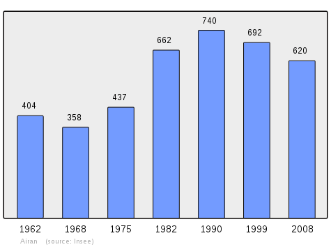
| 1962 | 1968 | 1975 | 1982 | 1990 | 1999 | 2006 | 2010 | - |
|---|---|---|---|---|---|---|---|---|
| 404 | 358 | 437 | 662 | 740 | 692 | 594 | 686 | - |
Sources : Ldh/EHESS/Cassini until 1962, INSEE database from 1968 (population without double counting and municipal population from 2006)
Culture and heritage
Civil heritage
The commune has a number of buildings and structures that are registered as historical monuments:
- A Water Mill (1682)
 is typical of the Caen region.[4]
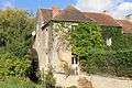
 - The Chateau of Coupigny (18th century)[5]
- The Chateau of Coupigny Park (18th century)[6]
- Other sites of interest
- Valmeray Tower and its surroundings are classified by DREAL Lower Normandy as an historical monument.[7] The ruined tower is located in a hamlet near Airan. An old legend tells of a secret passage connecting the tower to the church at Airan. The legend also says that the old bell in gold from the church is hidden in the secret passage. Many people have tried to find it but without success.
- The Alley of Lime Trees along the D43 is also registered with DREAL.[8]
Religious heritage
The commune has several religious buildings and structures that are registered as historical monuments:
- The Church of Saint Germain (12th century)[9] has a Romanesque facade.
Picture Gallery
-
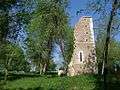
Valmeray Tower
-
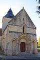
The Church of Saint-Germain
-
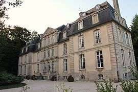
Coupigny Castle
-
The Watermill
-
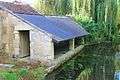
The Lavoir (Public laundry) on the Muance river
-
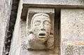
Gargoyle on the Church
See also
- Communes of the Calvados department
- Cantons of the Calvados department
- Arrondissements of the Calvados department
External links
- Airan on Lion1906
- Airan on Google Maps
- Airan on Géoportail, National Geographic Institute (IGN) website (French)
- Airan on the 1750 Cassini Map
- Airan on the INSEE website (French)
- INSEE (French)
Notes and references
Notes
- ↑ At the beginning of the 21st century, the methods of identification have been modified by law No. 2002-276 of 27 February 2002 , the so-called "law of local democracy" and in particular Title V "census operations" which allow, after a transitional period running from 2004 to 2008, the annual publication of the legal population of the different French administrative districts. For municipalities with a population greater than 10,000 inhabitants, a sample survey is conducted annually, the entire territory of these municipalities is taken into account at the end of the period of five years. The first "legal population" after 1999 under this new law came into force on 1 January 2009 and was based on the census of 2006.
References
- ↑ Inhabitants of Calvados (French)
- 1 2 3 Google Maps
- ↑ List of Mayors of Airan
- ↑ Ministry of Culture, Mérimée PA00111009 Water Mill (French)
- ↑ Ministry of Culture, Mérimée PA00111007 Chateau of Coupigny (French)

- ↑ Ministry of Culture, Mérimée IA14003357 Chateau of Coupigny Park (French)
- ↑ DREAL Basse-Normandie (French)
- ↑ DREAL Basse-Normandie (French)
- ↑ Ministry of Culture, Mérimée PA00111008 Church of Saint Germain (French)
| Wikimedia Commons has media related to Airan. |