Aladağ, Adana
| Aladağ | |
|---|---|
 Aladağ | |
| Coordinates: 37°32′47.37″N 35°23′55.42″E / 37.5464917°N 35.3987278°ECoordinates: 37°32′47.37″N 35°23′55.42″E / 37.5464917°N 35.3987278°E | |
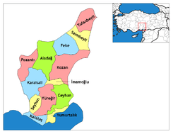
| Country | Turkey |
| Province | Adana |
| Government | |
| • Mayor | Mustafa Akgedik (AKP) |
| • Kaymakam | Ahmet Ziya Filizer[1] |
| Area[2] | |
| • District | 1,347.33 km2 (520.21 sq mi) |
| Elevation | 921 m (3,022 ft) |
| Population (2012)[3] | |
| • Urban | 4,224 |
| • District | 16,951 |
| • District density | 13/km2 (33/sq mi) |
| Post code | 01720 |
| Website |
www |
Aladağ, formerly Karsantı, is a small city and a district in Adana Province, Turkey about 100 km north of the city of Adana, up in the mountains. This is an undeveloped area, the people live from agriculture and forestry. People from the Çukurova retreat up here in the summer to escape the heat on the plain, although it's too high up for a day trip.
The Aladağlar mountains are an eastern extension of the Taurus Mountains. These high mountains are a popular area for climbing, usually accessed from the north through the town of Niğde. The town of Aladağ sits on their southern side, accessed by road up from Adana. There is no pass through the mountains.
References
- ↑ Kaymakam Retrieved 2015-10-19.
- ↑ "Area of regions (including lakes), km²". Regional Statistics Database. Turkish Statistical Institute. 2002. Retrieved 2013-03-05.
- ↑ "Population of province/district centers and towns/villages by districts - 2012". Address Based Population Registration System (ABPRS) Database. Turkish Statistical Institute. Retrieved 2013-02-27.
External links
- (Turkish) District governor's official website
- (Turkish) District municipality's official website
- Miscellaneous images of Aladağ
This article is issued from Wikipedia - version of the 11/12/2016. The text is available under the Creative Commons Attribution/Share Alike but additional terms may apply for the media files.