Bageshwar
| Bageshwar बागेश्वर | |
|---|---|
| city | |
|
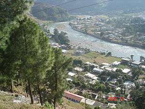
A bird's eyeview of Bageshwar | |
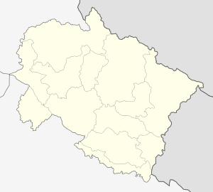 Bageshwar  Bageshwar Location in Uttarakhand, India | |
| Coordinates: 29°51′N 79°46′E / 29.85°N 79.77°ECoordinates: 29°51′N 79°46′E / 29.85°N 79.77°E | |
| Country |
|
| State | Uttarakhand |
| Division | Kumaon |
| District | Bageshwar |
| Government | |
| • Type | Muncipal Council |
| • Mayor | Subodh Sha |
| Area | |
| • Total | 5.50 km2 (2.12 sq mi) |
| Elevation | 1,004 m (3,294 ft) |
| Population (2011) | |
| • Total | 9,079 |
| • Density | 1,700/km2 (4,300/sq mi) |
| Languages | |
| • Official |
Hindi Sanskrit |
| • Spoken | Kumaoni |
| Time zone | IST (UTC+5:30) |
| PIN | 263642 |
| Vehicle registration | UK-02 |
| Website |
uk |
Bageshwar is a city and a municipal board in Bageshwar district in the state of Uttarakhand, India. It is located at a distance of 470 km from the National Capital New Delhi and 502 km from the State Capital Dehradun.[1] Bageshwar is known for its scenic beauty, Glaciers, Rivers and Temples. It is also the administrative headquarters of Bageshwar district.[2]
Situated on the confluence of Sarju and Gomati rivers,[3][4] the city of Bageshwar gets its name from the Bagnath Temple.[5] Hindi and Sanskrit are the official Languages however Kumaoni is spoken by a large number of people.
History
Bageshwar has historically been a part of Kumaon Kingdom. Bageshwar was located adjacent to Kartikeypura, the then capital of Katyuri Kings that ruled over Kumaon in the 7th century.[6] According to historians, Nepalese invader Kranchaldev won the Bageshwar region by defeating Katyuri kings in 1191.[7] He later weakened the Katyuris and kept his local governors to rule the region. These governors later became independent before Chand king Balo Kalyan Chand of Almora won the region from local Khas rulers in 1565.[8] In the 10th century, the Chand kingdom was established by Som Chand. He displaced the Katyuri Kings, called his state Kurmanchal and established its capital in Champawat in Kali Kumaon.[9][10][11][12] In 1568,[13] Kalyan Chand established a permanent capital at Khagmara[14] and called it Almora.[15][16][17]
In 1791, the Gorkhas of Nepal while expanding their kingdom westwards across Kali River, invaded and overran Almora,[18] the seat of the Kumaon Kingdom and other parts of Kumaon including Bageshwar. The Gorkhas were defeated by the East India Company[19] in Anglo-Nepalese War in 1814[20][21][22] and were forced to cede Kumaon to the British as part of the Treaty of Sugauli in 1816.[23]:594[24]
The Kumaon region was joined with the eastern half of the Garhwal region and was governed as a chief-commissionership, also known as the Kumaon Province, on the non-regulation system.[25] According to Atkinson's The Himalayan Gazetteer, Bageshwar had a population of 500 in 1886.[26] In 1891 the division was composed of the three districts of Kumaon, Garhwal and the Tarai; but the two districts of Kumaon and the Tarai were subsequently redistributed and renamed after their headquarters, Nainital and Almora.
Before the First World War, the British Government did a Survey for a rail link connecting Bageshwar with Tanakpur in 1902.[27][28] However, the project was stalled by British due to The World War. The Surveys restarted in the 1980s after Indira Gandhi visited Bageshwar. The first motor road arrived in Bageshwar in 1952 from Almora via Garur. Bus services started operating on the Bageshwar-Kapkot motorway in 1955-56. After the 1962 India-China War, an important strategic road connecting Bageshwar with Pithoragarh was completed in 1965.
In the early phase of its urban development, the central township of Bageshwar was a group of 9 small mutually tangled group of villages which had three uninhabited and 6 manned village. The Bageshwar State village was formed in 1948 by joining these villages. Bageshwar was declared a town in 1955, under the UP Town Area Act of 1914, and the first Town area committee was constituted in 1957.[29] Bageshwar received the status of a notified area committee in 1962 and municipal Council in 1968. The pumping water supply scheme was introduced in Bageshwar town in 1975.[29] The estimate for water supply was prepared in 1968-69 for a designed population of 6000 persons for the year 1997.
In the early Twentieth century dispensary (1906) and Post Office (1909) were established in Bageshwar. A public school started in 1926, which was made junior high school in 1933. After independence by several attempts from local residents, a private high school was opened in 1949 in memory of Victor Mohan Joshi, which became an Inter College in 1967. The first women's primary school started in the 1950s and women's public high school started in 1975. A new Government Degree College was inaugurated in 1974 by the then Chief Minister Hemwati Nandan Bahuguna.
After Independence of India in 1947, Bageshwar was a part of the Almora District.[30] Bageshwar had a population of 1740 people according to the 1951 Census. It was part of the Kanda development block, that was later converted into Bageshwar development block. On September 15, 1997 the Bageshwar district was carved out of Almora district[5] by then Uttar Pradesh Chief Minister Mayawati and Bageshwar became its Headquarter. On 9 November 2000, Bageshwar came in the Uttarakhand State that was created from the Himalayan and adjoining northwestern districts of Uttar Pradesh.[31]
Geography and Climate

Bageshwar is located at 29°29′N 79°27′E / 29.49°N 79.45°E[32] in Bageshwar District in Uttarakhand. It is situated 470 km North-East of the National Capital New Delhi and 502 km South-East of the State Capital Dehradun. It lies in the Kumaon division[33] and is situated 153 km North-East of Nainital, the Headquarters of Kumaon. Bageshwar is situated in a valley of the Kumaon Hills of the Central Himalaya range.[34] It has an average elevation of 1,004 m (3,294 ft) above mean Sea Level. The chief trees are the Chir Pine, Himalayan Cypress, Pindrow Fir, alder, sal or iron-wood, and saindan. Limestone, sandstone, slate, gneiss and granite constitute the principal geological formations.
Its climate is characterized by relatively high temperatures and evenly distributed precipitation throughout the year. In summer, Bageshwar is largely under the influence of moist, maritime airflow from the western side of the subtropical anticyclonic cells over low-latitude ocean waters. Temperatures are high and can lead to warm, oppressive nights. Summers are usually somewhat wetter than winters, with much of the rainfall coming from convectional thunderstorm activity; tropical cyclones also enhance warm-season rainfall in some regions. The coldest month is usually quite mild, although frosts are not uncommon, and winter precipitation is derived primarily from frontal cyclones along the polar front. The Köppen Climate Classification subtype for this climate is "Cfa". (Humid Subtropical Climate).
The average temperature for the year in Bageshwar is 20.4 °C (68.8 °F). The warmest month, on average, is June with an average temperature of 27.3 °C (81.2 °F). The coolest month on average is January, with an average temperature of 11 °C (51.8 °F). The average amount of precipitation for the year in Bageshwar is 48.1" (1221.7 mm). The month with the most precipitation on average is July with 13.0" (330.2 mm) of precipitation. The month with the least precipitation on average is November with an average of 0.2" (5.1 mm). There are an average of 63.6 days of precipitation, with the most precipitation occurring in August with 15.3 days and the least precipitation occurring in November with 0.8 days.
| Climate data for Bageshwar, India | |||||||||||||
|---|---|---|---|---|---|---|---|---|---|---|---|---|---|
| Month | Jan | Feb | Mar | Apr | May | Jun | Jul | Aug | Sep | Oct | Nov | Dec | Year |
| Average high °C (°F) | 17.2 (63) |
19.5 (67.1) |
25 (77) |
30.7 (87.3) |
33.7 (92.7) |
32.9 (91.2) |
29.4 (84.9) |
28.9 (84) |
28.7 (83.7) |
27.4 (81.3) |
23.6 (74.5) |
19.1 (66.4) |
26.4 (79.5) |
| Daily mean °C (°F) | 11.0 (51.8) |
13.1 (55.6) |
18.1 (64.6) |
23.6 (74.5) |
26.8 (80.2) |
27.4 (81.3) |
25.4 (77.7) |
26.8 (80.2) |
24.2 (75.6) |
21.3 (70.3) |
16.8 (62.2) |
12.7 (54.9) |
20.5 (68.9) |
| Average low °C (°F) | 4.9 (40.8) |
6.7 (44.1) |
11.2 (52.2) |
16.5 (61.7) |
19.8 (67.6) |
21.8 (71.2) |
21.5 (70.7) |
21.3 (70.3) |
19.8 (67.6) |
15.2 (59.4) |
10.0 (50) |
6.3 (43.3) |
14.6 (58.3) |
| Average precipitation mm (inches) | 32.9 (1.295) |
35.1 (1.382) |
30.1 (1.185) |
24.4 (0.961) |
43.7 (1.72) |
157.0 (6.181) |
328.9 (12.949) |
328.2 (12.921) |
178.4 (7.024) |
42.5 (1.673) |
6.0 (0.236) |
13.6 (0.535) |
1,220.8 (48.063) |
| Average precipitation days | 2.7 | 2.9 | 2.8 | 2.1 | 3.0 | 8.1 | 14.2 | 15.3 | 8.3 | 2.3 | 0.8 | 1.1 | 63.6 |
| Mean daily sunshine hours | 10.9 | 11.6 | 12.4 | 13.3 | 14.1 | 14.5 | 14.3 | 13.6 | 12.7 | 11.8 | 11.1 | 10.7 | 12.6 |
| Source: Weatherbase[35] | |||||||||||||
Demographics

| Bageshwar population | |||
|---|---|---|---|
| Census | Pop. | %± | |
| 1951 | 1,740 | — | |
| 1961 | 2,189 | 25.8% | |
| 1971 | 4,314 | 97.1% | |
| 1981 | 4,225 | -2.1% | |
| 1991 | 5,772 | 36.6% | |
| 2001 | 7,803 | 35.2% | |
| 2011 | 9,079 | 16.4% | |
| Sources:[37][38][39] | |||
According to the 2011 census of India, Bageshwar has a population of 9,079 comprising 4,711 males and 4,368 females.[38] Males constitute approximately 55% of the population and females 45%. The sex ratio of bageshwar is 1090 women per 1000 men,[40] higher than the national Average of 940 women per 1000 men.[41] The City ranked 4th in Uttarakhand in terms of Sex Ratio.[42] Bageshwar has an average literacy rate of 80%, higher than the national average of 72.1%; with 84% of the males and 76% of females literate.[39] 11% of the population is under 6 years of age.[39] 2,219 people belong to the Scheduled Castes while the population of people belonging to Scheduled Tribes is 1,085.[39] Bageshwar had a population of 7803 according to 2001 Census[43] and 5,772 according to the 1991 census.[38]
Out of total population, 2,771 were engaged in work or business activity. Of this 2,236 were males while 535 were females.[39] In census survey, worker is defined as person who does business, job, service, and cultivator and labour activity.[44] Of total 2771 working population, 78.06% were engaged in Main Work while 21.94% of total workers were engaged in Marginal Work.[45]
Hinduism is practiced by 93.34% of total population and is the religion of the Majority in Bageshwar.[36] Other Religions include Islam (5.93%), Sikhism (0.25%), Christianity (0.26%), Buddhism (0.01%) and Jainism (0.02%).[36]
Kumaoni, a dialect of Central Pahari is the mother tongue of majority however, Hindi and Sanskrit[46] are the official languages of the state. Garhwali and English are also spoken by a small number of people.
Government and Politics
The Bageshwar Assembly seat is reserved for a person belonging to the Scheduled Castes. Chandan Ram Das from Bharatiya Janata Party is the present MLA OF Bageshwar.[47] Bageshwar is a "Nagar Palika Parishad" (Municipal Council) city in district of Bageshwar, Uttarakhand.[48] The Bageshwar city is divided into 7 wards for which elections are held every 5 years.[49] The Bageshwar Nagar Palika Parishad has population of 9,079 of which 4,711 are males while 4,368 are females as per report released by Census India 2011. Shubodh Sha from Bharatiya Janata Party is the Mayor of Bageshwar.[50] Bageshwar Nagar Palika Parishad has total administration over 2,054 houses to which it supplies basic amenities like water and sewerage. It is also authorized to build roads within Nagar Palika Parishad limits and impose taxes on properties coming under its jurisdiction. The Uttarakhand Power Corporation Ltd. (UPCL) is responsible for supply of electricity in the city. Uttarakhand Jal Vidyut Nigam Ltd. generates electricity from the 8.5 MW electric sub-station at Bageshwar. The Notified Area Committee, Bageshwar is responsible for approval of building plans after getting no objection certificate from various departments like Jal Nigam, PWD, Electricity Board and Health Department etc.
Economy
The city was once rich in agriculture and animal husbandry. Besides growing crops, people were mainly engaged in sheep rearing. However, agriculture and sheep rearing in Bageshwar have suffered as villagers, who are increasingly joining armed forces, after retirement are settling down in Bageshwar town instead of their native villages.[5]
The traditional Uttarayani festival organised since centuries on the banks of the Sarju and Gomati rivers was the main place where woollen outfits made by Saukas of Munsiyari were brought form higher valleys for ages, thus strengthening trade links between the two communities.[8]
As of 2006, Bageshwar had a total of 6 Health Care units including four Hospitals (Two Allopathik, one Ayurvedik and one Homoepathik), one Maternity & Child welfare centre and one Community Health Centre.[51] Bageshwar has a total of Five Nationalized Bank’s, Two Post Offices, One Telegraph Office, 80 PCO'S and 1844 Telephone Connections.[29] Mobile Communication services are provided by Private companies like Vodafone, Airtel, Idea, Reliance etc.
Culture
Many classical dance forms and folk art are practised in the city. Some well-known dances include Hurka Baul, Jhora-Chanchri, Jhumaila, and Chholiya.[52] Music is an integral part of the Kumaoni culture. Popular types of folk songs include Mangal, Basanti, Khuded and Chhopati.[53] These folk songs are played on instruments including dhol, damau, turri, ransingha, dholki, daur, thali, bhankora, mandan and mashakbaja.Music is also used as a medium through which the gods are invoked. Jagar is a form of spirit worship in which the singer, or Jagariya, sings a ballad of the gods, with allusions to great epics, like Mahabharat and Ramayana, that describe the adventures and exploits of the god being invoked.
The primary food of Bageshwar is vegetables with wheat being a staple. A distinctive characteristic of Uttarakhand cuisine is the sparing use of tomatoes, milk, and milk based products. Coarse grain with high fibre content is very common in Uttarakhand due to the harsh terrain. Another crop which is associated with Uttarakhand is Buckwheat (locally called Madua or Jhingora). Generally, either Desi Ghee or Mustard oil is used for the purpose of cooking food. Simple recipes are made interesting with the use of hash seeds "Jakhiya" as spice. Bal Mithai is a popular fudge-like sweet. Other popular dishes include Dubuk, Chains, Kap, Chutkani, Sei, and Gulgula. A regional variation of Kadhi called Jhoi or Jholi is also popular.[54]
Temples
Hinduism is practiced by 93.34% and is the religion of the Majority in Bageshwar[36] therefore Various Temples are situated in Bageshwar.[55] the major one being:
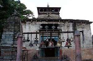
At the junction of the rivers, Gomti and Sarju stands a large temple with its conical tower. Here is the shrine of Bageswar or Vyagreswar, the, "Tiger Lord", an epithet of Lord Siva. This temple was erected by the Kumaun king, Laxmi Chand, about 1450 A.D.,[56] but there is an interesting Sanskrit inscription there of a far earlier date. The temple is flooded with devotees on the annual occasion of Shivratri. This place has a cluster of temples. Prominent amoug these temples are the Bairav temple, Dattatrey Maharaj, Ganga Mai temple, Hanuman temple, Durga temple, Kalika temple, Thingal Bhirav temple, Panchnam Junakhara and the Vaneshwar temple.
- Chandika Temple
A beautiful temple dedicated to Goddess Chandika stands at a distance of about half a kilometre from Bageshwar. Every year, the temple bustles with activity as the devout congregate here to offer pujas to the deity during the Navratras.
- Sriharu Temple
Another important temple, the Sriharu temple, is situated at a distance of about 5 km from Bageshwer. The devotees believe that prayers for wish fulfilment here never go in vein. Every year, a large fair is organised on the Vijya Dashmi day following the Navratras.
- Gauri Udiyar
This is situated 8 km from Bageshwer. A large cave, measuring 20 X 95 sq mts is situated here, which houses the idols of Lord Shiva.
Transport
Pantnagar Airport, located in Pantnagar is the primary Airport serving entire Kumaon Region. The Government is planning to develop Naini Saini Airport in Pithoragarh[57] which once developed will be much nearer. Indira Gandhi International Airport, located in Delhi is the nearest international Airport.
Kathgodam railway station is the nearest railway station. Kathgodam is the last terminus of the broad gauge line of North East Railways that connects Kumaon with Delhi, Dehradun, and Howrah. A new Railway line connecting Bageshwar with Tanakpur has been a long-standing demand of the people of the region.[58][59][60] the tanakpur-Bageshwar rail link was first planned by British in 1902.[27] However the project was stalled by Railway ministry in 2016[27] citing the commercial viability of the rail line.[61]
Bageshwar is well connected by motorable roads with major destinations of Uttarakhand state and northern India. Uttarakhand Transport Corporation runs Buses Bageshwar bus station to Delhi, Dehradun and Almora.[62] Taxis and Private Buses, mostly run by K.M.O.U, connect Bageshwar to other major destinations of Kumaon region.[63] A Sub Regional Transport Office is located in Bageshwar[64] where Vehicles are registered by the number UK-02.[65]
Education
There are mainly government-run, private unaided (no government help), and private aided schools in the city. The language of instruction in the schools is either English or Hindi. The main school affiliations are CBSE, CISCE or UBSE, the state syllabus defined by the Department of Education of the Government of Uttarakhand. There are Eleven junior basic schools, three senior basic schools, two higher secondary schools and one post-graduate college to serve the needs of the population.[51] The teacher-student ratio in Bageshwar is 1:47.[29] Bageshwar has an average literacy rate of 80%, with 84% of the males and 76% of females literate.[39]
See also
External links
References
- ↑ Indusnettechnologies, Goutam Pal, Dipak K S, SWD. "Location: District of Bageshwar, Uttarakhand, India". bageshwar.nic.in. Retrieved 3 August 2016.
- ↑ "Bageshwar PinCode". citypincode.in. Retrieved 2014-03-17.
- ↑ Dehradun, NIC, Uttarakhand State Unit,. "District of Almora , Uttarakhand, India". almora.nic.in. Retrieved 9 September 2016.
- ↑ "नमामी सरयू योजना शुरू करे सरकार 14430986". Retrieved 3 August 2016.
- 1 2 3 "development gains elude kumaon's holy place". Retrieved 3 August 2016.
- ↑ Omacanda Hāṇḍā (2002). History of Uttaranchal. Indus Publishing. pp. 63–. ISBN 978-81-7387-134-4. Retrieved 22 July 2012.
- ↑ Bruce, Charles Granville. Twenty Years in the Himalaya - Scholar's Choice Edition. Scholar's Choice. ISBN 9781294961789. Retrieved 8 September 2016.
- 1 2 "Home to ancient Katyuri culture". Retrieved 4 August 2016.
- ↑ Gupta, Om. Encyclopaedia of India, Pakistan and Bangladesh. Gyan Publishing House. ISBN 9788182053922.
- ↑ Budhwar, Kusum. Where Gods Dwell: Central Himalayan Folktales and Legends. Penguin Books India. ISBN 9780143066026.
- ↑ Singh, Kumar Suresh; India, Anthropological Survey of. People of India. Anthropological Survey of India. p. 35. ISBN 9788173041143.
- ↑ Handa, Madhu Jain By-O. C. Art & Architecture of Uttarakhand. Pentagon Press. ISBN 9788182744172.
- ↑ Trivedi, Vijaya R. Autonomy of Uttarakhand. Mohit Publications. p. 33. ISBN 9788174450081.
- ↑ Sen, Siba Pada. The Sino-Indian Border Question: A Historical Review. Institute of Historical Studies. p. 68. Retrieved 8 September 2016.
- ↑ Sharma, Man Mohan. Through the valley of gods: travels in the central Himalayas. Vision Books. p. 99.
- ↑ Bhattacherje, S. B. Encyclopaedia of Indian Events & Dates. Sterling Publishers Pvt. Ltd. p. 55. ISBN 9788120740747.
- ↑ Omacanda Hāṇḍā (2002). History of Uttaranchal. Indus Publishing. pp. 71–. ISBN 978-81-7387-134-4. Retrieved 22 July 2012.
- ↑ Hamilton, Francis; Buchanan, Francis Hamilton. An Account of the Kingdom of Nepal: And of the Territories Annexed to this Dominion by the House of Gorkha. A. Constable. Retrieved 2 September 2016.
- ↑ Lamb, Alastair (1986). British India and Tibet, 1766-1910 (2nd, rev. ed. ed.). London: Routledge & Kegan Paul. ISBN 0710208723.
- ↑ Cross, John Pemble ; foreword by J.P. (2008). Britain's Gurkha War : the invasion of Nepal, 1814-16 ([Rev. ed.] ed.). London: Frontline. ISBN 978-1-84832-520-3.
- ↑ Naravane, M.S. (2006). Battles of the honourable East India Company : making of the Raj. New Delhi: A. P. H. Pub. Corp. ISBN 978-81-313-0034-3.
- ↑ Gould, Tony (2000). Imperial warriors : Britain and the Gurkhas. London: Granta Books. ISBN 1-86207-365-1.
- ↑ Martin, Robert Montgomery. The History of the Indian Empire. Mayur Publications.
- ↑ Summary of the operations in India: with their results : from 30 April 1814 to 31 Jan. 1823. Marquis of Hastings. 1824.
- ↑ Robert Montgomery Martin, History of the Possessions of the Honourable East India Company, Volume 1, pg. 107
- ↑ Atkinson, Edwin Thomas (1973). The Himalayan gazetteer. Cosmo Publications. Retrieved 28 August 2016.
- 1 2 3 "Rail ministry stalls Tanakpur-Bageshwar link project - Times of India". Retrieved 4 August 2016.
- ↑ "टनकपुर-बागेश्वर रेल लाइन का 1902 में हुआ था आगाज!". hindi.pradesh18.com. Retrieved 9 September 2016.
- 1 2 3 4 Perspective Plan of Bageshwar District-2021 (PDF). Government of Uttarakhand. Retrieved 29 August 2016.
- ↑ Times World Atlas, 1967 Edition, Plate 30.
- ↑ "About Us". Government of Uttarakhand. Retrieved 17 July 2012.
- ↑ Falling Rain Genomics, Inc - Bageshwar
- ↑ Kumaon Himalaya. Shree Almora Book Depot. ISBN 9788190020992.
- ↑ Illustrated Atlas of the Himalaya. India Research Press. ISBN 9788183860376.
- ↑ "Bageshwar, India Travel Weather Averages (Weatherbase)". Weatherbase.
- 1 2 3 4 "Bageshwar District Religion Data - Census 2011". www.census2011.co.in. Retrieved 5 August 2016.
- ↑ Gopi, K.N (1978). Process of urban fringe development: A model. Concept Publishing Company. Retrieved 6 August 2013.
- 1 2 3 "Uttarakhand (India): Districts, Cities, Towns and Outgrowth Wards - Population Statistics in Maps and Charts". www.citypopulation.de.
- 1 2 3 4 5 6 2011 census, BAGESHWAR (PDF). Retrieved 4 August 2016.
- ↑ "bageshwar-district-glance". Retrieved 5 August 2016.
- ↑ "लिंगानुपात की स्थिति चिंताजनक- Amarujala". Retrieved 5 August 2016.
- ↑ "Uttarakhand: Sex Ratio as per Census 2011". 15 February 2014. Retrieved 5 August 2016.
- ↑ "Census of India 2001: Data from the 2001 Census, including cities, villages and towns (Provisional)". Census Commission of India. Archived from the original on 2004-06-16. Retrieved 2008-11-01.
- ↑ "Worker (Census Definition) - Arthapedia". www.arthapedia.in. Retrieved 5 August 2016.
- ↑ "Bageshwar City Population Census 2011 - Uttarakhand". www.census2011.co.in. Retrieved 5 August 2016.
- ↑ Trivedi, Anupam (19 January 2010). "Sanskrit is second official language in Uttarakhand". Hindustan Times. Archived from the original on 1 February 2012. Retrieved 29 July 2012.
- ↑ Election Results 2012, Uttarakhand State.pdf (PDF). Retrieved 4 August 2016.
- ↑ "Panchayats, Municipalities and Corporations in Bageshwar District.". IndiaStudyChannel.com. Retrieved 5 August 2016.
- ↑ "Bageshwar City Population Census 2011 - Uttarakhand". www.census2011.co.in. Retrieved 5 August 2016.
- ↑ List of Elected Mayor-Chairparson of Uttarakhand as per ULB election 2008 (PDF). Retrieved 5 August 2016.
- 1 2 Indusnettechnologies, Goutam Pal, Dipak K S, SWD. Statistical Handbook, District of Bageshwar, Uttarakhand, India.
- ↑ "Folk Dances Of North India". culturalindia.net. Retrieved 29 July 2012.
- ↑ "Folk Songs of Uttarakhand". aboututtarakhand.com. Retrieved 29 July 2012.
- ↑ Subodh Upadhyay, An Essence of Himalaya, a book about Uttarakhand cuisine
- ↑ Indusnettechnologies, Goutam Pal, Dipak K S, SWD. "Temples: District of Bageshwar, Uttarakhand, India". bageshwar.nic.in. Retrieved 5 August 2016.
- ↑ "Bagnath Temple (Bageshwar)". onlytravelguide.com.
- ↑ Prashant, Shishir. "Govt seeks Rs 25 cr from Centre for Naini-Saini airport". Retrieved 4 August 2016.
- ↑ Prashant, Shishir. "Demand for Tanakpur-Bageshwar railway line resurfaces". Retrieved 4 August 2016.
- ↑ "'Tanakpur-Bageshwar rail project need of the hour'". www.dailypioneer.com. Retrieved 4 August 2016.
- ↑ "ex mp tamta demands three railway lines". Retrieved 4 August 2016.
- ↑ "Tanakpur-Bageshwar rail line commercially not viable: Suresh Prabhu – RailNews Media India Ltd". www.railnews.co.in. Retrieved 4 August 2016.
- ↑ Dehradun, NIC, Uttarakhand State Unit,. "Routes". utc.uk.gov.in. Retrieved 5 August 2016.
- ↑ "Bageshwar Transportation - Car, Train, Bus & Taxi, Bageshwar Local Transport - MakeMyTrip". www.makemytrip.com. Retrieved 5 August 2016.
- ↑ Dehradun, NIC, Uttarakhand State Unit,. "State Transport Department , Government Of Uttarakhand, India". transport.uk.gov.in. Retrieved 5 August 2016.
- ↑ Dehradun, NIC, Uttarakhand State Unit,. "District Registration Numbers: State Transport Department , Government Of Uttarakhand, India". transport.uk.gov.in. Retrieved 5 August 2016.