Byrnedale, Pennsylvania
| Byrnedale, Pennsylvania | |
|---|---|
| Census-designated place | |
 Byrnedale | |
| Coordinates: 41°17′32″N 78°30′16″W / 41.29222°N 78.50444°WCoordinates: 41°17′32″N 78°30′16″W / 41.29222°N 78.50444°W | |
| Country | United States |
| State | Pennsylvania |
| County | Elk |
| Township | Jay |
| Area | |
| • Total | 1.2 sq mi (3.2 km2) |
| • Land | 1.2 sq mi (3.2 km2) |
| • Water | 0.0 sq mi (0.0 km2) |
| Elevation | 1,225 ft (373 m) |
| Population (2010) | |
| • Total | 427 |
| • Density | 342/sq mi (131.9/km2) |
| Time zone | Eastern (EST) (UTC-5) |
| • Summer (DST) | EDT (UTC-4) |
| ZIP code | 15827 |
| FIPS code | 42-10600 |
| GNIS feature ID | 1170843 |
Byrnedale is an unincorporated community and census-designated place in Elk County, Pennsylvania. As of the 2010 census, the population was 427.[1]
It is located in Jay Township, in the valley of Kersey Run, and is bordered to the south by Weedville. Pennsylvania Route 255 passes through Byrnedale, leading north 11 miles (18 km) to St. Marys and southwest 20 miles (32 km) to DuBois.
References
- ↑ "Geographic Identifiers: 2010 Demographic Profile Data (G001): Byrnedale CDP, Pennsylvania". American Factfinder. U.S. Census Bureau. Retrieved March 14, 2016.
Municipalities and communities of Elk County, Pennsylvania, United States | ||
|---|---|---|
| City | 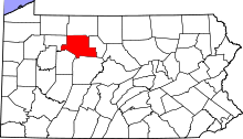 | |
| Boroughs | ||
| Townships | ||
| CDPs | ||
| Unincorporated communities | ||
External links
- Byrnedale PA – Start-up website for the city of Byrnedale PA
This article is issued from Wikipedia - version of the 3/14/2016. The text is available under the Creative Commons Attribution/Share Alike but additional terms may apply for the media files.