Wilcox, Pennsylvania
| Wilcox, Pennsylvania | |
|---|---|
| Census-designated place | |
|
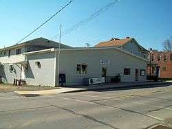
U.S. Post Office and Jones Township Municipal Authority, Wilcox, Pennsylvania | |
 Wilcox Location within the state of Pennsylvania | |
| Coordinates: 41°34′32″N 78°41′18″W / 41.57556°N 78.68833°WCoordinates: 41°34′32″N 78°41′18″W / 41.57556°N 78.68833°W | |
| Country | United States |
| State | Pennsylvania |
| County | Elk |
| Township | Jones |
| Area | |
| • Total | 0.5 sq mi (1.3 km2) |
| • Land | 0.5 sq mi (1.3 km2) |
| • Water | 0.0 sq mi (0.0 km2) |
| Elevation | 1,526 ft (465 m) |
| Population (2010 census) | |
| • Total | 383 |
| • Density | 746/sq mi (288.2/km2) |
| Time zone | Eastern (EST) (UTC-5) |
| • Summer (DST) | EDT (UTC-4) |
| ZIP code | 15870 |
| FIPS code | 42-85088 |
| GNIS feature ID | 1210116 |
Wilcox is an unincorporated community and census-designated place located in Jones Township, Elk County, Pennsylvania, United States.[1] The community was named after a settler, Col. A.I. Wilcox. The Swedish Lutheran Parsonage located at 230 Kane Street was added to the National Register of Historic Places in 2005.[2] As of the 2010 census, Wilcox had a population of 383.[3]
The year 2008 marked the 150th anniversary of the settling of this village. Wilcox is located on the Allegheny Plateau near the East Branch Clarion River Lake. Over 250,000 visitors a year come to Wilcox to enjoy the natural foresting, fishing, hunting, and three state and national parks.
Wilcox is located in the west-central part of Jones Township in northern Elk County, in the valley of the West Branch of the Clarion River, a tributary of the Allegheny River. U.S. Route 219 passes through the center of town, leading north 29 miles (47 km) to Bradford and south 14 miles (23 km) to Ridgway, the Elk County seat. Pennsylvania Route 321 leads northwest from Wilcox 9 miles (14 km) to Kane.
References
- ↑ U.S. Geological Survey Geographic Names Information System: Wilcox, Pennsylvania
- ↑ National Park Service (2009-03-13). "National Register Information System". National Register of Historic Places. National Park Service.
- ↑ "Geographic Identifiers: 2010 Demographic Profile Data (G001): Wilcox CDP, Pennsylvania". American Factfinder. U.S. Census Bureau. Retrieved March 14, 2016.
External links
Municipalities and communities of Elk County, Pennsylvania, United States | ||
|---|---|---|
| City | 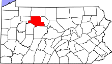 | |
| Boroughs | ||
| Townships | ||
| CDPs | ||
| Unincorporated communities | ||