James City, Pennsylvania
| James City, Pennsylvania | |
|---|---|
| Census-designated place | |
 James City | |
| Coordinates: 41°37′11″N 78°50′21″W / 41.61972°N 78.83917°WCoordinates: 41°37′11″N 78°50′21″W / 41.61972°N 78.83917°W | |
| Country | United States |
| State | Pennsylvania |
| County | Elk |
| Township | Highland |
| Area | |
| • Total | 0.7 sq mi (1.8 km2) |
| • Land | 0.7 sq mi (1.8 km2) |
| • Water | 0.0 sq mi (0.0 km2) |
| Elevation | 1,950 ft (590 m) |
| Population (2010) | |
| • Total | 287 |
| • Density | 415/sq mi (160.3/km2) |
| Time zone | Eastern (EST) (UTC-5) |
| • Summer (DST) | EDT (UTC-4) |
| ZIP code | 16734 |
| FIPS code | 42-37656 |
| GNIS feature ID | 1209704 |
James City is an unincorporated community and census-designated place in Elk County, Pennsylvania, United States. It lies approximately 4 miles (6 km) south of Kane, about 1 mile (1.6 km) away from Pennsylvania Route 66. It is in the northern part of Highland Township, and its northern border is the McKean County line. As of the 2010 census the CDP population was 287.[1]
References
- ↑ "Geographic Identifiers: 2010 Demographic Profile Data (G001): James City CDP, Pennsylvania". American Factfinder. U.S. Census Bureau. Retrieved March 14, 2016.
Municipalities and communities of Elk County, Pennsylvania, United States | ||
|---|---|---|
| City | 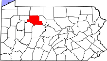 | |
| Boroughs | ||
| Townships | ||
| CDPs | ||
| Unincorporated communities | ||
This article is issued from Wikipedia - version of the 3/14/2016. The text is available under the Creative Commons Attribution/Share Alike but additional terms may apply for the media files.