Calumet Township, Cook County, Illinois
| Calumet Township | |
|---|---|
| Township | |
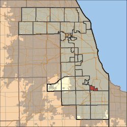 Location in Cook County | |
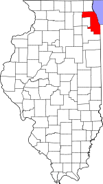 Cook County's location in Illinois | |
| Coordinates: 41°39′28″N 87°39′13″W / 41.65778°N 87.65361°WCoordinates: 41°39′28″N 87°39′13″W / 41.65778°N 87.65361°W | |
| Country | United States |
| State | Illinois |
| County | Cook |
| Area | |
| • Total | 4.7 sq mi (12.1 km2) |
| • Land | 4.4 sq mi (11.4 km2) |
| • Water | 0.3 sq mi (0.7 km2) 5.79% |
| Elevation | 597 ft (182 m) |
| Population (2010) | |
| • Total | 20,777 |
| • Density | 4,720/sq mi (1,822.5/km2) |
| Time zone | CST (UTC-6) |
| • Summer (DST) | CDT (UTC-5) |
| ZIP codes | 60406 60827 |
| GNIS feature ID | 0428750 |
Calumet Township is one of 29 townships in Cook County, Illinois, USA. As of the 2010 census, its population was 20,777.[1]
Geography
According to the United States Census Bureau, Calumet Township covers an area of 4.7 square miles (12.1 km2); of this, 4.4 square miles (11.4 km2) is land and 0.27 square miles (0.7 km2), or 5.79 percent, is water.[1]
Cities, towns, villages
- Blue Island (east half)
- Calumet Park
- Riverdale
Adjacent townships
- Thornton Township (southeast)
- Bremen Township (southwest)
- Worth Township (west)
Cemeteries
The township contains Cedar Park Cemetery.
Major highways
Rivers
Landmarks
- Calumet Woods (Cook County Forest Preserves)
- Whistler Preserve (Cook County Forest Preserves)
Political districts
- Illinois' 1st congressional district
- State House District 27
- State House District 28
- State House District 30
- State Senate District 14
- State Senate District 15
References
- "Calumet Township, Cook County, Illinois". Geographic Names Information System. United States Geological Survey. Retrieved 2010-01-10.
- United States Census Bureau 2007 TIGER/Line Shapefiles
- United States National Atlas
- 1 2 "Geographic Identifiers: 2010 Demographic Profile Data (DP-1): Calumet township, Cook County, Illinois". U.S. Census Bureau, American Factfinder. Retrieved March 20, 2013.
External links
This article is issued from Wikipedia - version of the 11/17/2016. The text is available under the Creative Commons Attribution/Share Alike but additional terms may apply for the media files.