Crystal Township, Hancock County, Iowa
| Crystal Township | |
|---|---|
| Township | |
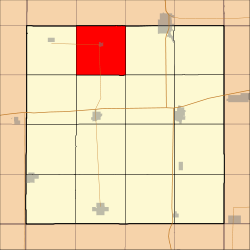 Location in Hancock County | |
| Coordinates: 43°13′13″N 93°47′36″W / 43.22028°N 93.79333°WCoordinates: 43°13′13″N 93°47′36″W / 43.22028°N 93.79333°W | |
| Country |
|
| State |
|
| County | Hancock |
| Area | |
| • Total | 35.5 sq mi (91.96 km2) |
| • Land | 35.11 sq mi (90.93 km2) |
| • Water | 0.4 sq mi (1.03 km2) 1.12% |
| Elevation | 1,299 ft (396 m) |
| Population (2000) | |
| • Total | 529 |
| • Density | 15.1/sq mi (5.8/km2) |
| Time zone | CST (UTC-6) |
| • Summer (DST) | CDT (UTC-5) |
| ZIP codes | 50423, 50432, 50436 |
| GNIS feature ID | 0467668 |
Crystal Township is one of sixteen townships in Hancock County, Iowa, USA. As of the 2000 census, its population was 529.[1]
History
Crystal Township was founded in 1869.[2] The township was named from Crystal Lake.[3]
Geography
According to the United States Census Bureau, Crystal Township covers an area of 35.5 square miles (91.96 square kilometers); of this, 35.11 square miles (90.93 square kilometers, 98.88 percent) is land and 0.4 square miles (1.03 square kilometers, 1.12 percent) is water.
Cities, towns, villages
Adjacent townships
- Linden Township, Winnebago County (north)
- Forest Township, Winnebago County (northeast)
- Madison Township (east)
- Garfield Township (southeast)
- Britt Township (south)
- Orthel Township (southwest)
- Bingham Township (west)
- Grant Township, Winnebago County (northwest)
Cemeteries
The township contains Crystal Township Cemetery.
Major highways
-
 Iowa Highway 111
Airports and landing strips
- South 80 Field
Lakes
- Crystal Lake
Landmarks
- Crystal Lake Roadside Park
- Ellsworth College Park
School districts
- Garner-Hayfield Community School District
- West Hancock Community School District
- Woden-Crystal Lake Community School District
Political districts
- Iowa's 4th congressional district
- State House District 11
- State Senate District 6
References
- United States Census Bureau 2008 TIGER/Line Shapefiles
- United States Board on Geographic Names (GNIS)
- United States National Atlas
- ↑ United States Census Bureau American FactFinder
- ↑ History of Kossuth, Hancock, and Winnebago Counties, Iowa. Union Publishing Company. 1884. p. 686.
- ↑ History of Winnebago County and Hancock County, Iowa. Pioneer Publishing Company. 1917. pp. 262–263.
External links

Municipalities and communities of Hancock County, Iowa, United States | ||
|---|---|---|
| Cities | ||
| Townships | ||
| CDPs | ||
| Other unincorporated communities | ||
| Footnotes | ‡This populated place also has portions in an adjacent county or counties | |
This article is issued from Wikipedia - version of the 12/3/2016. The text is available under the Creative Commons Attribution/Share Alike but additional terms may apply for the media files.