Fresnaye, Cape Town
| Fresnaye | |
|---|---|
|
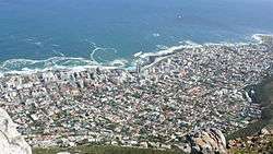
Fresnaye and Sea Point as seen from Lion's Head which surrounds the suburb on the East. Sea Point is to the North and the West separating the suburb from the Atlantic Ocean. | |
 Fresnaye  Fresnaye  Fresnaye
| |
|
Location within Cape Town 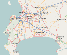 Fresnaye | |
| Coordinates: 33°55′30″S 18°23′15″E / 33.92500°S 18.38750°ECoordinates: 33°55′30″S 18°23′15″E / 33.92500°S 18.38750°E | |
| Country | South Africa |
| Province | Western Cape |
| Municipality | City of Cape Town |
| Main Place | Cape Town |
| Government | |
| • Type |
Metropolitan Council Ward 54 |
| • Councillor | Beverley Schäfer [1] (DA) |
| Area[2] | |
| • Total | 0.73 km2 (0.28 sq mi) |
| Population (2011)[2] | |
| • Total | 2,011 |
| • Density | 2,800/km2 (7,100/sq mi) |
| Racial makeup (2011)[2] | |
| • Black African | 9.5% |
| • Coloured | 4.0% |
| • Indian/Asian | 0.8% |
| • White | 83.1% |
| • Other | 2.6% |
| First languages (2011)[2] | |
| • English | 81.2% |
| • Afrikaans | 9.8% |
| • Xhosa | 1.8% |
| • Other | 7.3% |
| Postal code (street) | 8005 |
Fresnaye is one of Cape Town's most affluent suburbs, situated between Signal Hill and Sea Point, a few kilometres to the west of Cape Town's Central Business District (CBD).
Geography
Fresnaye is set on the slopes of Lion’s Head on the East and between Sea Point and Bantry Bay to the suburb's North West and South West respectively.
References
- ↑ "Councillor Details: Beverley Schäfer". City of Cape Town. Retrieved March 24, 2013.
- 1 2 3 4 "Sub Place Fresnaye". Census 2011.
.svg.png)
This article is issued from Wikipedia - version of the 6/12/2016. The text is available under the Creative Commons Attribution/Share Alike but additional terms may apply for the media files.