Gümüşhacıköy
| Gümüşhacıköy | |
|---|---|
 Gümüşhacıköy | |
| Coordinates: 40°52′N 35°13′E / 40.867°N 35.217°ECoordinates: 40°52′N 35°13′E / 40.867°N 35.217°E | |
| Country |
|
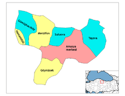
| Province | Amasya |
| Government | |
| • Mayor | Zehra Özyol (CHP) |
| Area[1] | |
| • District | 654.25 km2 (252.61 sq mi) |
| Population (2012)[2] | |
| • Urban | 14,028 |
| • District | 23,673 |
| • District density | 36/km2 (94/sq mi) |
Gümüşhacıköy is located in the westernmost district of Amasya Province of Turkey, 20 km from the larger town of Merzifon. It covers an area of 653 km², and the population (2010 census) is 24,806 of which 14,525 live in the town of Gümüşhacıköy, with the remainder spread throughout the surrounding mountainous countryside. The mayor is Zehra Özyol (CHP).
The name Gümüşhacıköy is an amalgamation of two separate villages Gümüş (silver) and Hacıköy (the village of pilgrims).
Climate
Gümüşhacıköy has a warm-summer Mediterranean climate (Köppen: Csb).
| Climate data for Gümüşhacıköy | |||||||||||||
|---|---|---|---|---|---|---|---|---|---|---|---|---|---|
| Month | Jan | Feb | Mar | Apr | May | Jun | Jul | Aug | Sep | Oct | Nov | Dec | Year |
| Daily mean °C (°F) | 0.5 (32.9) |
2.0 (35.6) |
5.3 (41.5) |
10.8 (51.4) |
14.9 (58.8) |
18.2 (64.8) |
20.4 (68.7) |
20.3 (68.5) |
17.2 (63) |
12.6 (54.7) |
7.3 (45.1) |
2.7 (36.9) |
11.0 (51.8) |
| Average precipitation mm (inches) | 40 (1.57) |
32 (1.26) |
37 (1.46) |
47 (1.85) |
61 (2.4) |
51 (2.01) |
19 (0.75) |
14 (0.55) |
24 (0.94) |
31 (1.22) |
36 (1.42) |
43 (1.69) |
435 (17.12) |
| Source: Climate-Data.org[3] | |||||||||||||
History
The town achieved some prosperity during the 13th and 14th centuries due to the nearby silver mines. Both the Seljuks and the Ilkhans minted coins in the town, then known as Gümüşbazar (Arabic: كمشبازار).[4]
The town grew and continued to thrive under Ottoman rule. The population shrank as the Ottoman Empire collapsed, and many men of Gümüşhacıköy were lost in the Balkan Wars and the First World War.
Today Gümüşhacıköy is a small town in attractive countryside. Successive generations migrate to larger cities in search of careers leaving an aging and shrinking population behind.
Places of interest
- The town has had a rich history and the many Seljuk and Ottoman buildings include urban architecture such as Bedestan (the covered bazaar), Büyük hamam (Turkish bath), and Kabak çeşmesi (fountain) and especially.....
- Mosques such as Haliliye Medresesi, Yörgüç Paşa Camii, Darphane Camii, Maden Camii (a converted church).
- There is also an attractive picnic area with a waterfall in the forests near the district of Şarlayuk.
Villages of Gümüşhacıköy
- Akpınar
- Alören
- Bacakoğlu
- Bademli
- Balıklı
- Beden
- Çalköy
- Çavuşköy
- Çetmi
- Çiftçioğlu
- Çitli
- Derbentobruğu
- Doluca
- Dumanlı
- Eslemez
- Güllüce
- Güplüce
- Güvemözü
- İmirler
- Karaali
- Karacaören
- Karakaya
- Kağnıcı
- Keçiköy
- Kiziroğlu
- Koltuk
- Konuktepe
- Korkut
- Kutluca
- Kuzalan
- Köseler
- Kılıçaslan
- Kırca
- Kızık
- Kızılca
- Ovabaşı
- Pusacık
- Sallar
- Saraycık
- Sarayözü
- Sekü
- Yazıyeri
References
- ↑ "Area of regions (including lakes), km²". Regional Statistics Database. Turkish Statistical Institute. 2002. Retrieved 2013-03-05.
- ↑ "Population of province/district centers and towns/villages by districts - 2012". Address Based Population Registration System (ABPRS) Database. Turkish Statistical Institute. Retrieved 2013-02-27.
- ↑ "Climate data for Gümüşhacıköy". Climate-Data.org. Retrieved 9 April 2014.
- ↑ Diler, Ömer; Hinrichs, Johann-Christoph (2009), Islamic Mints (İslam darp yerleri), 2, Istanbul: Spink, pp. 1049–1050, ISBN 978-975-8428-18-2