Golden, Missouri
| Golden, Missouri | |
|---|---|
| Census-designated place & unincorporated community | |
 Golden | |
| Coordinates: 36°31′27″N 93°39′14″W / 36.52417°N 93.65389°WCoordinates: 36°31′27″N 93°39′14″W / 36.52417°N 93.65389°W | |
| Country | United States |
| State | Missouri |
| County | Barry |
| Area[1] | |
| • Total | 5.7 sq mi (14.8 km2) |
| • Land | 5.3 sq mi (13.8 km2) |
| • Water | 0.4 sq mi (1.0 km2) |
| Elevation | 1,050 ft (320 m) |
| Population (2010) | |
| • Total | 280 |
| • Density | 53/sq mi (20.3/km2) |
| Time zone | Central (CST) (UTC-6) |
| • Summer (DST) | CDT (UTC-5) |
| Area code(s) | 417 |
| GNIS feature ID | 0750065[2] |
Golden is an unincorporated community and census-designated place in southeastern Barry County about 20 miles (32 km) southeast of Cassville. It is located south of Table Rock Lake and one mile north of Missouri Route 86 on Highway J. As of the 2010 census it had a population of 280.[3]
A post office called Golden has been in operation since 1876.[4] The community most likely was named after the local Golden family.[5]
Eureka Springs, Arkansas, is located about 16 miles (26 km) south of Golden.
References
- ↑ "US Gazetteer files: 2010, 2000, and 1990". United States Census Bureau. 2011-02-12. Retrieved 2011-04-23.
- ↑ "Golden, Missouri". Geographic Names Information System. United States Geological Survey.
- ↑ "Geographic Identifiers: 2010 Demographic Profile Data (G001): Golden CDP, Missouri". U.S. Census Bureau, American Factfinder. Retrieved January 23, 2014.
- ↑ "Post Offices". Jim Forte Postal History. Retrieved 30 August 2016.
- ↑ "Barry County Place Names, 1928-1945 (archived)". The State Historical Society of Missouri. Retrieved 30 August 2016.
Municipalities and communities of Barry County, Missouri, United States | ||
|---|---|---|
| Cities | 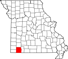 | |
| Villages | ||
| Townships | ||
| CDPs | ||
| Unincorporated communities | ||
| Ghost towns | ||
| Footnotes | ‡This populated place also has portions in an adjacent county or counties | |
This article is issued from Wikipedia - version of the 9/11/2016. The text is available under the Creative Commons Attribution/Share Alike but additional terms may apply for the media files.