McDowell Township, Barry County, Missouri
| McDowell Township | |
|---|---|
| Township | |
 | |
| Coordinates: 36°49′31″N 093°47′52″W / 36.82528°N 93.79778°WCoordinates: 36°49′31″N 093°47′52″W / 36.82528°N 93.79778°W | |
| Country | United States |
| State | Missouri |
| County | Barry |
| Area | |
| • Total | 23.85 sq mi (61.78 km2) |
| • Land | 23.85 sq mi (61.78 km2) |
| • Water | 0 sq mi (0 km2) 0% |
| Elevation[1] | 1,296 ft (395 m) |
| Population (2000) | |
| • Total | 275 |
| • Density | 11.5/sq mi (4.5/km2) |
| FIPS code | 29-44966[2] |
| GNIS feature ID | 0766260 |
McDowell Township is one of twenty-five townships in Barry County, Missouri, United States. As of the 2000 census, its population was 275.
Geography
McDowell Township covers an area of 23.85 square miles (61.8 km2) and contains no incorporated settlements.
The streams of Calton Creek, Gunter Creek, Little Flat Creek, Stansberry Creek and Willow Branch run through this township.
References
- ↑ "US Board on Geographic Names". United States Geological Survey. 2007-10-25. Retrieved 2008-01-31.
- ↑ "American FactFinder". United States Census Bureau. Archived from the original on September 11, 2013. Retrieved 2008-01-31.
External links
Municipalities and communities of Barry County, Missouri, United States | ||
|---|---|---|
| Cities | 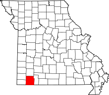 | |
| Villages | ||
| Townships | ||
| CDPs | ||
| Unincorporated communities | ||
| Ghost towns | ||
| Footnotes | ‡This populated place also has portions in an adjacent county or counties | |
This article is issued from Wikipedia - version of the 9/10/2016. The text is available under the Creative Commons Attribution/Share Alike but additional terms may apply for the media files.