Gosairhat Upazila
| Gosairhat গোসাইরহাট | |
|---|---|
| Upazila | |
 Gosairhat Location in Bangladesh | |
| Coordinates: 23°5′N 90°26′E / 23.083°N 90.433°ECoordinates: 23°5′N 90°26′E / 23.083°N 90.433°E | |
| Country |
|
| Division | Dhaka Division |
| District | Shariatpur District |
| Establishment | 1921 |
| Granted Upazila status | 1983 |
| Area[1] | |
| • Total | 196.72 km2 (75.95 sq mi) |
| Population (2011 census)[2] | |
| • Total | 157,665 |
| • Density | 800/km2 (2,100/sq mi) |
| Time zone | BST (UTC+6) |
| • Summer (DST) | BDST (UTC+7) |
| Postal code | 8050 |
| Calling Code | +88 (06024) |
| Website |
gosairhat |
Gosairhat (Bengali: গোসাইরহাট) is an upazila of Shariatpur District in the Division of Dhaka, in south central Bangladesh.
Geography
Gosairhat Upazila has a total area of 196.72 square kilometres (75.95 sq mi).[1] It is the southernmost upazila of Shariatpur District. Located on the western bank of the Meghna River, it borders Damudya and Bhedargan upazilas to the north, Haimchar Upazila of Chandpur District to the east, Muladi and Hizla upazilas of Barisal District to the south, and Kalkini Upazila of Madaripur District to the west.
The upazila headquarters is spread over the only two urban areas of the upazila, Dhipur and Daser Jangal mauzas. Together they have a total area of 4.33 square kilometres (1.67 sq mi).[2][3]
Demographics
| Historical population | ||
|---|---|---|
| Year | Pop. (000) | ±% |
| 1981 | 189 | — |
| 1991 | 115 | −39.2% |
| 2001 | 124 | +7.8% |
| 2011 | 158 | +27.4% |
| 2011 population increased sharply because upazila boundaries were redrawn to include Kuchaipatti Union Source: Bangladesh Bureau of Statistics[1] | ||
According to the 2011 Bangladesh census, Gosairhat Upazila had 33,169 households and a population of 157,665, 7.0% of whom lived in urban areas.[2] 12.7% of the population was under the age of 5.[4] The literacy rate (age 7 and over) was 42.1%, compared to the national average of 51.8%.[5][6]
The boundaries of the upazila were expanded in 2006 by the addition of Kuchaipatti Union, transferred from adjacent Hizla Upazila of Barisal District. The transfer accounts for 21,313 of the growth in population from 2001. Without it the population increase from 2001 to 2011 would have been 10.5%.[2]
Economy
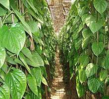
Agriculture is the main economic activity. It contributed almost 70.86% to the economy at the 2001 census. Other sources are livestock, forestry, fishery, business, hawking, rural transport and non-agricultural labor. Main crops are paddy, chilly, jute, paan (betel leaf) and (Bengali: খেজুরের গুড়) (date tree molasses). Paan is mostly exported to capital city Dhaka and abroad also.
Administration
Gosairhat Upazila is divided into eight union parishads: Alawalpur, Goshairhat, Idilpur, Kodalpur, Kuchaipatti, Nager Para, Nalmuri, and Samantasar. The union parishads are subdivided into 84 mauzas and 221 villages.[1]
In the 2009 upazila elections, Fazlur Rahman was elected Upazila Chairman, while Chowdhury Ahsan Siddiqui and Ferdousi Begum were elected vice chairmen.[7] The Upazila Nirbahi Officer (UNO), who administers the upazila for the central government, is MST Kamrunnahar.[8] Each union is managed by a Union Parishad Chairman.
Parliamentary constituency Shariatpur-3 covers Damudya and Gosairhat upazilas, and the Bhedarganj Thana portion of Bhedarganj Upazila. Nahim Razzak of the Bangladesh Awami League was elected Member of Parliament in a 2012 by-election in which he was unopposed.[9][10]
Education
Shamsur Rahman Degree College is the only college in the upazila.
The madrasa education system includes three fazil madrasas.[11]
Media
Some major national newspapers are published in Dhaka, including The Daily Ittefaq, Prothom Alo, Naya Diganta, Inqilab, Janakantha and Amar Desh are available in Gosairhat. There is also a press club in Gosairhat. Satellite television channels like NTV, Channel i, ATN Bangla, Channel One, Ekushey Television, RTV, Boishaki TV,[12] Banglavision TV, as well as terrestrial television channel Bangladesh Television are available in the upazila.
See also
References
- 1 2 3 4 "District Statistics 2011: Shariatpur" (PDF). Bangladesh Bureau of Statistics. Retrieved July 25, 2014.
- 1 2 3 4 "Population Census 2011: Shariatpur Table C-01" (PDF). Bangladesh Bureau of Statistics. Retrieved July 11, 2014.
- ↑ Haque, Majedul (2012). "Gosairhat Upazila". In Islam, Sirajul; Jamal, Ahmed A. Banglapedia: National Encyclopedia of Bangladesh (Second ed.). Asiatic Society of Bangladesh.
- ↑ "Population Census 2011: Shariatpur Table C-04" (PDF). Bangladesh Bureau of Statistics. Retrieved July 11, 2014.
- ↑ "Population Census 2011: Shariatpur Table C-06" (PDF). Bangladesh Bureau of Statistics. Retrieved July 11, 2014.
- ↑ "Population and Housing Census 2011: Bangladesh at a Glance" (PDF). Bangladesh Bureau of Statistics. Retrieved July 21, 2014.
- ↑ "Upazila Election Centerwise Result Details 2009". Bangladesh Election Commission. Retrieved 13 August 2014.
- ↑ "List of Upazila Nirbahi Officers". Ministry of Public Administration. Archived from the original on September 28, 2013.
- ↑ "Delimination of Constituencies" (PDF). Election Commission Bangladesh. 2013. Retrieved 23 July 2014.(Bengali)
- ↑ "Nahim sworn in as MP". Daily Sun. Dhaka. 1 March 2012. Retrieved 12 August 2014.
- ↑ "List of Institutions". Ministry of Education. Retrieved July 15, 2014.
- ↑ http://www.boishakhi.tv/
| Upazila/Thana: | ||
|---|---|---|
