Gryfice
| Gryfice | |||
|---|---|---|---|
|
Sights of Gryfice | |||
| |||
 Gryfice | |||
| Coordinates: 53°54′53″N 15°11′55″E / 53.91472°N 15.19861°E | |||
| Country |
| ||
| Voivodeship | West Pomeranian | ||
| County | Gryfice County | ||
| Gmina | Gmina Gryfice | ||
| City rights | 1262 | ||
| Government | |||
| • Mayor | Andrzej Wacław Szczygieł | ||
| Area | |||
| • Total | 12.4 km2 (4.8 sq mi) | ||
| Population (2008) | |||
| • Total | 16,632 | ||
| • Density | 1,300/km2 (3,500/sq mi) | ||
| Time zone | CET (UTC+1) | ||
| • Summer (DST) | CEST (UTC+2) | ||
| Postal code | 72-300 | ||
| Car plates | ZGY | ||
| Website | http://www.urzad.gryfice.eu/ | ||


Gryfice ([ɡrɨˈfʲit͡sɛ]; Kashubian: Grëfice), formerly known by its German name Greifenberg,[1] is a town in Pomerania, north-western Poland with 16 632 inhabitants (2008). It is the capital of Gryfice County in West Pomeranian Voivodeship (since 1999), previously in Szczecin Voivodeship (1975–1998).
History
The Battle of Niekładź took place in the area of Gryfice in 1121, in which Polish ruler Bolesław III Krzywousty defeated Wartislaw I, Duke of Pomerania and Swantopolk I, Duke of Pomerania[2][3]
In 1262, throughout the German Ostsiedlung, Wartislaw III, Duke of Pomerania founded a town under Lübeck law on the Rega river. After his death, his successor, Barnim I, Duke of Pomerania, named the settlement Civitat Griphemberch super Regam (Griffinsmountain) after the coat of arms symbol of the Dukes of Pomerania. In 1365 the town entered the Hansa and prospered due to the right of free navigation on the Rega.
A town wall was built and at the end of the 13th century the construction of the St. Mary’s church was begun. In a document of 1386 a Latin school is mentioned, which is generally called the oldest in Pomerania. After the death of the last Pomeranian Duke and by the Treaty of Westphalia Greifenberg became part of Brandenburg-Prussia in 1648 and part of Imperial Germany in 1871. In 1818 the town became the capital of the Greifenberg district (Kreis Greifenberg).
In 1894 the town was connected to the railway line Altdamm - Kolberg. On July 1, 1896 the Greifenberger Kleinbahn was opened, a narrow-gauge railway today used as a railway Museum.
At the end of World War II Soviet Red Army conquered the town, approximately 40 percent of the town was destroyed by a fire. Following the post-war boundary changes, Greifenberg was renamed Gryfice and became Polish. Its German population was expelled and the town was populated with Poles, many of them expellees themselves from Polish areas annexed by the Soviet Union.
Demographics
Before the end of World War II the (then-German) inhabitants were predominantly Protestant. With the transformation into a Polish town after World War II, the majority of its population has been composed of Catholics.
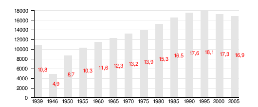
| Year | Inhabitants | Notes |
|---|---|---|
| 1740 | 1,724[4] | |
| 1782 | 1,890 | incl. 20 Jews.[4] |
| 1794 | 2,138 | incl. 19 Jews.[4] |
| 1812 | 2,445 | incl. 15 Catholics and 35 Jews.[4] |
| 1816 | 2,610 | incl. 44 Catholics and 35 Jews.[4] |
| 1831 | 3,272 | incl. 13 Catholics and 82 Jews.[4] |
| 1843 | 4,027 | incl. 9 Catholics and 132 Jews.[4] |
| 1852 | 4,886 | incl. 15 Catholics and 129 Jews.[4] |
| 1861 | 5,361 | incl. 31 Catholics, and 134 Jews.[4] |
| 1900 | 6,477[5] | |
| 1925 | 8,370 | incl. 110 Catholics, 80 Jews and 630 others.[6] |
| 1939 | 10,800 | |
| 1946 | 4,900 | after expulsion of Germans after World War II and war losses |
| 1950 | 8,700 | |
| 1960 | 11,600 | |
| 1970 | 13,200 | |
| 1980 | 15,300 | |
| 1990 | 17,600 | |
| 2000 | 17,300 |
Notable residents
- David Christiani (1610–1688), German Lutheran
- Karl Wilhelm Gottlob Kastner, (1783–1857), scientist
- Gustav von Struensee (1803–1875), author
- Friedrich Heinrich Albert Wangerin (1844–1933), mathematician
- Richard C. H. Lenski (1864−1936), Lutheran scholar
- Conrad Pochhammer (1873–1932), physician
- Moritz Seeler (1896–1942), author and film producer
- Ehrengard Schramm (1900–1985), politician
- Walter Neitzel (1913–1944), Wehrmacht officer
- Friedrich-Karl Krützmann (1917–2004), German officer
- Grzegorz Krychowiak (1990–present), professional footballer
International relations
Twin towns — Sister cities
Gryfice is twinned with:
References
- Literature
- Gustav Kratz: Die Städte der Provinz Pommern - Abriß ihrer Geschichte, zumeist nach Urkunden. Berlin 1865 (reprinted in 1996 by Sändig Reprint Verlag, Vaduz/Liechtenstein, ISBN 3-253-02734-1; reprinted in 2011 by Kessinger Publishing, U.S.A., ISBN 1-161-12969-3), pp. 32–38 (online).
- Notes
- ↑ "
 Baynes, T.S.; Smith, W.R., eds. (1880). "Greifenberg". Encyclopædia Britannica. 11 (9th ed.). p. 183.. 1880.
 - ↑ Rodowód książat pomorskich Szczecin 2005 page 94-95, 98
- ↑ Richard Roepell: Geschichte Polens, vol. I, Hamburg 1840, pp. 267-268 (in German)
- 1 2 3 4 5 6 7 8 9 Kratz (1965), p. 176.
- ↑ Meyers Konversations-Lexikon. 6th edition, vol. 8, Leipzig and Vienna 1907, p. 272.
- ↑ Der Große Brockhaus. 15th edition, vol. 2, Leipzig 1929, p. 488.
External links
| Wikimedia Commons has media related to Gryfice. |
![]() "Greifenberg". Encyclopædia Britannica. 12 (11th ed.). 1911.
"Greifenberg". Encyclopædia Britannica. 12 (11th ed.). 1911.
- Official website (Polish)
- narrow-gauge railway museum (German)
- Jewish Community in Gryfice on Virtual Shtetl
Coordinates: 53°54′53″N 15°11′55″E / 53.91472°N 15.19861°E
| Seat |  | |
|---|---|---|
| Villages | ||
Seat: Gryfice | ||
| Urban-rural gminas |  | |
| Rural gminas | ||