Kurseong
| Kurseong | |
|---|---|
| Town | |
|
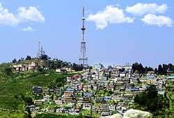
Panorama of Kurseong | |
| Nickname(s): The School Town[1] | |
 Kurseong Location of Kurseong in West Bengal | |
| Coordinates: 26°52′40″N 88°16′38″E / 26.87778°N 88.27722°ECoordinates: 26°52′40″N 88°16′38″E / 26.87778°N 88.27722°E | |
| Country |
|
| State | West Bengal |
| District | Darjeeling |
| Government | |
| • Body | Kurseong Municipality |
| • Chairman | Samir Dip Blon |
| • Vice Chairman | Kalpana Pradhan |
| Area | |
| • Total | 5.05 km2 (1.95 sq mi) |
| Elevation | 1,500 m (4,900 ft) |
| Population (2011) | |
| • Total | 42,446 (Kurseong Municipality)[2] |
| Languages | |
| • Regional | Bengali and Nepali[3] |
| Time zone | IST (UTC+5:30) |
| PIN | 734 203 |
| Telephone code | 0354 |
| Vehicle registration | WB-02, 73, 74, 76, 77 |
| Lok Sabha constituency | Darjeeling |
| Vidhan Sabha constituency | Kurseong |
| Website | Official Site |
Kurseong (Bengali: কার্শিয়াং) is a hill station and sub-divisional town in the Darjeeling district of the Indian state of West Bengal.
Located at an altitude of 1,458 metres (4,783 ft),[4] Kurseong is 32 kilometres (20 mi) from Darjeeling[5] and has a pleasant climate throughout the year.
Kurseong is 47 kilometres (29 mi) from Siliguri and is connected to the city by road and the Darjeeling Himalayan Railway. The nearest airport is at Bagdogra and the nearest major railway station is New Jalpaiguri [NJP], which is about 53 kilometres (33 mi) from the town. The economy is based primarily on education and tourism.
Etymology
The origin of the name is unclear; stories suggest it comes from the Lepcha language word for "small orchid", kurson-rip because of the little white orchids (Coelogyne cristata) dotting the valleys, or perhaps the term for a stick made out of a local cane.(O'Malley 1999, p. 216)
History
The original inhabitants were the Lepcha people, who named their home "Kurseong", because every spring it was alive and bright with Kurson-Rip orchids. In the remote past, Kurseong was a part of the Kingdom of Sikkim, even before the British came to India. However, in around 1780 the Nepalese conquered and annexed Kurseong and its surrounding areas. Then came the Gurkha War, which the Nepalese lost. The 1817 Treaty of Titalia restored Kurseong to Sikkim.[6]
With its mountains providing a cool and dry environment in the summer, Kurseong was a favourite of the British. Nevertheless, they found travelling there from the plains of Bengal difficult, even on warm sunny days because of the mountains. Although a road was built from Kurseong to Darjeeling from Titalia in the 1770s and 1780s, its irregular maintenance soon made the new route, the Military Road, almost useless. The next route, Hill Cart Road (now Tenzing Norgay Road), opened in 1861 and fared better.
Nevertheless, in 1835, the British decided that Darjeeling would make an excellent sanitorium and summer residence for their military and civilian officers along with their families. Negotiations with the Chogyal of Sikkim, Tshudpud Namgyal, provided them a strip of hill territory in Kurseong for an annual fee. As one of the hill stations on the road to Darjeeling, Kurseong began to develop.
Kurseong is home to one of the oldest municipalities in the state of West Bengal. Established as an independent Municipality in 1879, it did not become a Sub-Division until 1890, when the District of Darjeeling was formed. Kurseong and the District were added to the Rajshahi Division (now West Central Bangladesh) by the British Raj for the Bengal Presidency. In 1908, they were transferred to the Bhagalpur Division in the same Presidency.
Before Independence, there were 12 ward commissioners. Four of them were appointed by the British Raj and it also appointed its own man, the Sub-Divisional Officer (S.D.O.), as their Chairman. In 1939, when Bengal became a province of British India, Kurseong was allowed to elect its own member to be the chairman but the Raj continued to send ward commissioners until India gained independence. Nevertheless, between 1939 and 1942, Kurseong grew rapidly. As of today Kurseong has 24 commissioners.
Sights


Kurseong is surrounded by a myriad of tea gardens. These include Castleton, Makaibarie, Ambotia and Goomtee, all of which can be visited.
The toy train station is the nucleus of the town. The train tracks run through the length of the town and are used for a sight seeing tour.
Religious sites
- The Ambootia Shiva Temple.
- Giddha Pahar Sita Ram Mandir
- Giddahpahar Durga Mata Mandir.
- Jagdish Mandir
This temple has very old idols (almost 300 years old) of Lord Jagannath (Lord Krishna). The speciality of this temple is that there are two idols of The Lord and both are of Lord Jagannath (Krishna). In other temples of Lord Jagannath there are three idols - Lord Krishna, Lord Balram and Devi Subhadra (Sister of Lord Krishna and Lord Balram). But in Jagdish Mandir - Kurseong both the idols are of The Lord.
- St. Pauls Church on Hill Cart Road, near St. Joseph's School.
- Buddhist Gompa in Monteviot.
- Kunsang Choiling Monastery at Upper Naya Busty.
- Juma Mosque in Hat Bazaar.
- Grotto and Catholic church in St. Mary's Hill.
Natural sites
- Eagle's Craig
- Deer Park - now known as Dowhill Park, on the Dowhill Road.
- The Kholas (Water Falls - Springs) like Whistle Khola (named by the British, as there is a bend and the toy train whistles when passing through it). It is also known as Hussain Khola (means river in the local language). Although relatively dry during the dry months of winter, it comes alive during the monsoon season. There is a story called the "gadiman" (bullock cart driver) by a famous local writer and is a staple story in the local school syllabus. Everyone who has been raised in those parts knows the story of the gadiman and hence the Khola (river).
- The Kettle Valley
Museums
- Netaji Subhas Chandra Bose Museum and NSC Bose Institute of Asiatic Studies, hosted in the house of his elder brother, Sarat Chandra Bose, are situated in the Giddhapahar area (5 to 10 minutes drive from the Railway station). Netaji was interned in this house by the British government in the late thirties. The house now displays priceless artifacts depicting the life of the freedom fighter. These include photocopies of the exchange of letters between Netaji and his would-be wife, Ms. Emilie, many rare photographs of his Indian National Army (INA), other memorabilia of the Indian Freedom Movement and a few personal belongings of Netaji and the Bose Family.
Other Sites
- Chimney: A walk or ride through the forest of Cryptomaria Japonica on the road, now called Aranya Sarani, leads to the vast open meadows at Chimney. The curious name of the place is reminiscent of the days when there was a bungalow here on the only road (Old Military Road) leading to Darjeeling. A long, dilapidated chimney, standing all alone, is the only remnant of the bungalow now.
Naya Busty Park: Located just above the Netaji Subhas Chandra Bose Museum.
Civic administration

Kurseong Municipality, which is over 125 years old (one of the oldest in the country), is the main civic administration body for the town of Kurseong. It is located at 13 Dowhill Road. The Municipality is divided into 20 wards [originally 12 wards] and each of the wards has its own ward commissioner. The current Chairman of the Municipal Committee is Mr. Samir Deep Blon, in office since 21 December 2011
The previous Chairman, until 2008, was Mr. P. C. Agarwal. But in early March 2008 his political party, the Gorkha National Liberation Front (GNLF), lost the control of the Committee in a no-confidence vote to the other Gorkha political party, the Gorkha Janmukti Morcha (GJMM). Since 2007, the GJMM has been campaigning for the creation of a separate state for the Indian Gorkhas, the original goal of the GNLF. Because of the no-confidence vote, Mr. Agarwal was forced to resign and the Municipal Committee was suspended.[7]
Kurseong has its own Munsif Magistrate Court and has the Police Station and Town Out Post in P B Road. The S.D.O. (Sub Divisional Officer) is the head of the administration for the Town.
Hospital and Health Care in Kurseong : Kurseong has a Sub Divisional Hospital and no private nursing homes or clinics unlike Kalimpong and Darjeeling.
Gorkha Public Library
Gorkha Public Library or Gorkha jana pustakalay was established in the year 1913,[8] as an initiative of the Indian Gorkhas to develop their culture, language and literature in the small town of Kurseong . It was probably the first Nepali public library project.[8] This small initiative played a vital role in the development of Indian Gorkha culture, language and literature. The library still exists today, and among other things is used as a polling station in local elections.[9]
Bloomfield Library: A well stocked library opposite of the post office. The timings are fairly convenient and there is a minimal fee.
Education
Housing a numberof schools, Kurseong is popularly nicknamed as "the school town" due to the emergence of many new schools in the town. The schools can be classified into two distinct groups. The English Medium and the Nepali Medium. The English medium schools are mostly affiliated to the Indian Certificate of Secondary Education, Delhi while the Nepali Medium Schools are affiliated to the State Education Board i.e. West Bengal Board of Secondary Education, Calcutta. Only one school Godwin Modern School is affiliated to the Central Board of Secondary Education, Delhi in Kurseong Town.
University Colleges
Kurseong has one college Kurseong College which is affiliated to the University of North Bengal. It provides undergraduate studies - Bachelor of Arts (General and Honours), Bachelor of Science and Bachelor of Commerce (General).
Darjeeling Polytechnic College offers courses in Civil, Computer, Electrical and Mechanical Engineering.
From 1889-1971 there was even a theological college on St. Mary's hill (2 kilometres (1.2 mi) north on the way to Darjeeling) training the Jesuit seminarians to the Catholic priesthood . til it was shifted to Delhi under the new name of Vidyajyoti College of Theology.
The old Theologate's building now hosts the Eastern Forest Rangers College, which provides training courses to the would-be Forest Rangers of India. There is a West Bengal Forest School near Deer Park and Victoria Boys School, Dowhill which also provides training for foresters as well.
About 6 kilometres (3.7 mi) north on the way to Darjeeling at Tung, there is an Industrial Training Institute (ITI) which offers various vocational course in plumbing, motor mechanics, and book binding.
Schools of Kurseong
ICSE & ISC STREAM
- St. Anthony's School (Separate Schools for Boys and Girls)
- Himali Boarding School (Co-Ed)
- Goethals Memorial School (Boys)
- St. Helens Secondary School (Girls)
- Jnaneshwar Memorial School
- Dowhill School
- Victoria
- Daises School
- Sunshine School
- Modern English School
- Glenhill School
- Bellvue School
- Carmel High School
WBBSE Stream
- Ramakrishna Girls High School
- Pushparani Roy Memorial School
- St. Alphonsus School
- St. Joseph's Girls High School
Higher Secondary Vocational
- Holy Cross Institute (Class 11 & 12)
Colleges
- Kurseong Govt. College
- Kurseong Polytechnic College
Transport

Kurseong is considered as Mid Point between Siliguri and Darjeeling. The nearest airport is the Bagdogra Airport and nearest major railway hub is New Jalpaiguri Railway Station. Kurseong is well connected to Siliguri, Darjeeling and Mirik. Several prepaid vehicles run from Kurseong to Darjeeling, Siliguri and Mirik. But Kurseong does not have a strong transport connection to Kalimpong and Gangtok. Only 2 vehicles to Gangtok and 1 vehicle to Kalimpong run from Kurseong everyday. Taxis also run to Pankhabari, Ambootia, Mahanadi, Tindharia, Latpanchor. North Bengal state buses also run from Darjeeling to Siliguri and NJP Station via Kurseong.
Kurseong also has a railway station where Toy Train runs to New Jalpaiguri and Darjeeling. Kurseong Station is a part of Darjeeling Himalayan Railway and comes under Katihar Division of Northeast Frontier Railway.
There are three roads between Kurseong and Siliguri: National Highway, Pankhabari Road and Rohini Road.
Distance from Kurseong to Various Places :
- Mahanadi - 8 km
- Sonada - 16 km
- Tindharia - 22 km
- Ghoom - 24 km
- Darjeeling - 34 km
- Siliguri - 35 km
- Mirik - 35 km
- Teesta Valley - 50 km
- Kalimpong - 70 km
- Rangpo - 80 km
- Gangtok - 120 km
Demographics
In 2011, the population of Kurseong Municipality was 42,446. The rural area in Kurseong Block had a population of 94,347.[2]
Media and communications
All India Radio has a local station in Kurseong which broadcasts various programs of mass interest. It was established in the year 1962.
Notable Residents
- Jung Bahadur Rana (1816–1877), the Prime Minister of Nepal and the founder of the Rana dynasty of Nepal
- Sister Nivedita (1867–1911), Scots-Irish social worker, author, teacher and a disciple of Swami Vivekananda
- Sri C. S. Gurung, who won gold for India in men’s field hockey at the 1952 Summer Olympics
- M. Fazlul Haque (b. 1938), High Court Justice of Bangladesh
- Ferdinand Perier (1875–1968), 3rd Archbishop of Calcutta (now Kolkata), (stayed during three years of his retirement (1962–1965))
- Peter Sarstedt (1941–), musician and singer, attended Victoria Boys' School
References
- ↑ "Kurseong Municipality Official Page". Retrieved 2015-09-16.
- 1 2 "District Census Handbook, Darjiling" (PDF). Directorate of Census Operations, West Bengal. 2011. Retrieved 29 September 2015.
- ↑ "Report of the Commissioner for Linguistic Minorities in India: 50th report (delivered to the Lokh Sabha in 2014)" (PDF). National Commissioner for Linguistic Minorities, Ministry of Minority Affairs, Government of India. p. 95. Retrieved 2015-09-16.
The Official Language of the State is Bengali. Bengali and Nepali have also been declared as Official Languages in Darjeeling and Kurseong
- ↑ Vijay Kumar Gupta (1 March 1987). Tourism In India. Gyan Publishing House. pp. 213 ff. ISBN 978-81-212-0124-7. Retrieved 1 November 2012.
- ↑ M.S. Kohli (1 April 2004). Mountains of India: Tourism, Adventure, Pilgrimage. Indus Publishing. pp. 172 ff. ISBN 978-81-7387-135-1. Retrieved 1 November 2012.
- ↑ Kurseong Municipality, "History" [of Kurseong]. Retrieved 2 February 2013
- ↑ "GNLF loses control over Kursong civic board", OutlookIndia.com, 18 March 2008. Retrieved 2 February 2013
- 1 2 Chalmers, Rhoderick (2009). "Education, institutions and elites building and bounding Nepali public life in early Twentieth Century India". In Tanka Bahadur Subba. Indian Nepalis: Issues and Perspectives. Concept Publishing Company. p. 127. ISBN 9788180694462.
- ↑ Information Booklet. Gorkhaland Territorial Administration Sabha Election - 2012
- ↑ http://wbtourism.gov.in/guest/lRlQENlbSpmYXpkMWpmSqVmVZpXV31TP
Bibliography
- O'Malley, Lewis Sydney Steward (1 January 1999). Bengal District Gazetteer : Darjeeling. Concept Publishing Company. ISBN 978-81-7268-018-3.
External links
| Wikimedia Commons has media related to Kurseong. |
- Official Website of the Kurseong Municipality
- Kurseong Social Network
- Kurseong Online @ KURSEONG.COM
- Information on Kurseong at West Bengal Government Website
- Information about Kurseong
- Photographs of Kurseong
- Discussion Forum for Kurseong
- Kurseong Map
- "Kurseong – the Land of the White Orchids", Nature Beyond for Tourism Alternatives, a website for travelers
- "Welcome to Kurseong", with an interactive map of the area, Eastern Himalayas, a website for travelers
Cities, towns and locations in Darjeeling District | |||||||||||||||
|---|---|---|---|---|---|---|---|---|---|---|---|---|---|---|---|
| Cities, municipal and census towns |
| ||||||||||||||
| Locations other than cities and towns | |||||||||||||||
| See also |
| ||||||||||||||