Tamluk
| Tamluk তমলুক Tamralipta, Tamolika, Tamralipti, Tamoluk | |
|---|---|
| Town | |
 Tamluk | |
| Coordinates: 22°18′N 87°55′E / 22.3°N 87.92°ECoordinates: 22°18′N 87°55′E / 22.3°N 87.92°E | |
| Country |
|
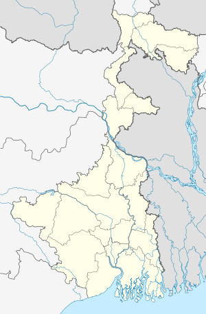
| State | West Bengal |
| District | Purba Medinipur |
| Elevation | 7 m (23 ft) |
| Population (2011)[1] | |
| • Total | 65,306 |
| Languages | |
| • Official | Bengali, English |
| Time zone | IST (UTC+5:30) |
| PIN | 721636 |
| Telephone code | 91-3228 |
| Vehicle registration | WB 29-xxxx,WB 30-xxxx |
| Lok Sabha constituency | Tamluk |
| Vidhan Sabha constituency | Tamluk, Moyna, Nandakumar |
| Website |
purbamedinipur |
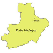
Tamluk (/ˈtæmlʊk/) (Bengali: তমলুক) is a town in India. It is the district headquarters of Purba Medinipur district of West Bengal, India. Though there is some controversy, scholars have generally agreed that present day Tamluk is the site of the ancient city variously known as Tamralipta or Tamralipti. The present town is located on the banks of the Rupnarayan River close to the Bay of Bengal.
Demographics
At the 2001 census of India, Tamluk had a population of 45,826. Males constituted 52% of the population and females 48%. Tamluk had an average literacy rate of 77%, higher than the national average of 59.5%; male literacy was 83%, and female literacy was 72%. 11% of the population was under 6 years of age.[2]
History
This ancient kingdom and port city was bounded by the Bay of Bengal in the south, Rupnarayan River in the east and Subarnarekha River in the west. The Rupnarayana is the joint flow of the rivers Dwarakeswar and Silai. The Bay of Bengal and these great rivers with their numerous branches created a prosperous and easy water navigational system fostering commerce, culture and early contacts with the people outside the region. At the same time, these rivers helped to develop the agriculture in this region.
Archaeological remains show continuous settlement from about the 3rd century BC. It was known as Tramralipta (in the Puranas and the Mahabharata), Tamralipta (in the Mahabharata), Tamalika (in historical documents), Tamalitti (in foreigners' descriptions), or Tamoluk (in the British Raj). It was a seaport, now buried under river silt. For this reason, Tamluk has many ponds and lakes remaining today.
In the Mahabharata (Bhishma Parba/Nabam Adhyay), while describing the names of the holiest rivers and kingdoms of India, Sanjay took the name of "Tramralipta" to Dhritarashtra.
Tamluk was also known as Bhivas, in religious texts, and Madhya Desh, as the Middle State of Utkal/Kalinga and Banga.
According to Jain sources, Tamralipti was the capital of the kingdom of Venga and was long known as a port.
Police station
Tamluk police station has jurisdiction over Tamluk (municipality) and Tamluk CD Block. Tamluk police station covers an area of 214.14 km2 with a population of 352,748.[3][4]
People
The people of Tamluk are primarily Bengali speaking. There are some lingering effects of successive migrations and invasions from both the west, east, and especially from northern India . Its history shows the complex combination of indigenous, Muslim, Buddhist, Jain and Hindu cultures, through trade, travel, and migration.
Unlike other parts of Bengal, Tamluk was always well connected with the Gangetic plains. In fact, there is evidence to suggest that the culture of Aryavarta influenced life in early Tamluk. The worship of Bheema is a sign of the socio-religious acceptance of Aryan culture in this area. Even in the recent past, Tamluk was divided into many areas based on caste and occupation, such as Malakar Para (flower traders), Adhikary Para (Brahmins), Metia Para in Nimtala (transport business and timber merchants), Dey Para (gold traders), and Mathore Para (sweeper's colony).
Economy
As a seaport, Tamluk was once famous as a centre for trade.
The main trade presently is of paan (betel leaf). The building of bus bodies is another important business, as is transport.
Agriculture
Tamluk is mainly an agricultural area. About 60% of the land is under cultivation. Tamluk is one of the largest producers and exporters of paan (betel leaf). Fishing was an important occupation of the local residents. Hilsa (Ilish Mach) of the River Rupnarayan is well known for its taste.
The area's main crops include rice, bananas, coconuts, potatoes, cotton, flowers, betel leaf, and fresh vegetables.
Transport
Tamluk is well linked by road and rail. Tamluk is a major roadway junction with six bus-routes originating from it:
- Tamluk to Srirampur , Tangrakhali and Pursha ghat
- Tamluk to Mecheda, Kolaghat, and Kolkata
- Tamluk to Panskura, Kharagpur and Ghatal
- Tamluk to Haldia, Durgachowk
- Tamluk to Digha, Contai, and Egra
NH 116 and SH 4 passes through Tamluk.
Tamluk is a railway junction; routes are given below:
- Howrah to Haldia, via Tamluk
- Howrah to Digha, via Tamluk and Contai
- Haldia to Kharagpur via Tamluk
- Haldia to Chennai via Tamluk
- Haldia to Anad Viher (Delhi) via Tamluk
Direct trains from Howrah Junction:
- Tamralipta Express
- Kandari Express
- Paharia Express (Saturday only)
Education
There are many schools and colleges in Tamluk.
- Tamralipta Mahavidyalaya[5] (Tamluk College) is one of the oldest colleges of this south-west region of West Bengal providing graduation courses.
There is no university in this but Indira Gandhi National Open University (IGNOU) has a presence in the form of a Study Centre with Tarun Sangha Information & Documentation Centre (TASIDOC) as the host institution.
ENGLISH MEDIUM SCHOOLS ARE
Sudhir Memorial Institute Tamluk
Tamralipta public School
Zilla Public School
Health
There is a district hospital in the town, named Tamluk District Hospital. People of this district and its surrounding area depend on this hospital.
Art and culture
Tamluk is well known for its cultural activities. There are several arts schools, dance academies and drama groups.DIKSUNNYA is a Bengali alternative rock band formed at Tamluk. DIKSUNNYA is the first band of Purba medinipur also.
Tamluk is also an important craft centre which benefits from its location, just 85 km south-west of Kolkata's markets.
Landmarks and tourist places
- Rupnarayan : The bank of river Rupnarayan is famous for picnic.
- Devi Barghobhima : Nearly 1150-year-old Temple of Kali named as Devi Bargobhima. This temple is a part of 51 Shakti Peethas. Puranas say that the small finger of left feet of Sati/Parvati fell here when Lord Vishnu cut the sacred Body of Goddess Sati into several pieces to make Lord Shiva quite.
- Tamluk Rajbari : It is on the outskirts of town. The literal translation for "rajbari" is king's house, once housing one of the many kings in West Bengal. The Mayura-dhwaja (Peackok) Dynasty had been named in Mahabharata, Bhagvat, Bramhabaibarto Puran etc. as a very rich and wealthest one of that region.
- Tamralipta Archeological Museum : It is an Archeological Museum in Tamluk; it is a must see place of the town. Dr. Kamal Kundu is the one of the prominent person who did his best to run this museum. The Tamralipta Museum at Tamluk contains artefacts of tamra or copper. Inscribed copper templates comprise the documents of this museum. The museum has preserved a tamralipta of Greek inscriptions. The Tamralipta Museum preserves the historical heritage of Bengal.
- Rakhit Bati : It is another place to visit in Tamluk. In the beginning of 19th century it was famous as a secret centre of the then revolutionary party ‘Anusilan Samiti’ & ‘Gupta samiti. Famous historian late Shri Tailakyanath Rakhit rebuilt this building.
- Matangani Sahid Smarak : It is at the side of pond called Banpukur at Abasbari Para near Tamluk Court. During the ‘Ahimsa’ movement of 1942, while a crowd trying to capture Tamluk administrative building, British police opened fire in which Smt Matangini Hazara became ‘Sahid’. Later on Mahatma Gandhi appreciated her bravery and titled her as ‘Birangana’. This monument is a homage to her by Ex- prime-minister, Smt Indira Gandhi. This is about 7 km from Tamluk station and on the way to Tamluk college.
- Tamluk irrigation Bungalow and its nearby areas : This area is famous for its semi-nonurban atmospheres. The River Rupnarayana is just 1 km from the bungalow.
- Geonkhali : At geonkhali river Rupnarayan joins Hooghly river with a beautiful backdrop.
- Mahishadal : Nearby tourist place.
- Kolaghat :- It is another town on the bank of Rupnarayan River and famous for Hilsa (Ilish) fishes.
- Green fields near the rail station is another popular picnic destination in Tamluk.
Notable people
- Khudiram Bose, young revolutionary
- Matangini Hazra, Indian independence movement revolutionary[6]
- Satish Chandra Samanta Indian independence movement activist
- Ajoy Mukherjee former chief minister of the state
- Paresh Maity artist
See also
References
- ↑ http://www.censusindia.gov.in/pca/SearchDetails.aspx?Id=365849
- ↑ Archived 4 November 2006 at the Wayback Machine.
- ↑ "District Statistical Handbook 2014 Purba Medinipur". Tables 2.1, 2.2. Department of Statistics and Programme Implementation, Government of West Bengal. Retrieved 10 November 2016.
- ↑ "Tamluk PS". Purba Medinipur District Police. Retrieved 10 November 2016.
- ↑ "Tamralipta Mahavidyalaya". Tamralipta Mahavidyalaya. Retrieved 28 September 2013.
- ↑ Amin, Sonia (2012). "Hazra, Matangini". In Islam, Sirajul; Jamal, Ahmed A. Banglapedia: National Encyclopedia of Bangladesh (Second ed.). Asiatic Society of Bangladesh.
External links
| Wikisource has the text of the 1911 Encyclopædia Britannica article Tamluk. |
-
 Tamluk travel guide from Wikivoyage
 - radioBollyFM-Live Radio From Tamluk
- Tamluk Municipality
- Purba Medinipur District Official Website
- Paschim Medinipur District Official Website
- Tamralipta Mahavidyalaya
- On temples of Midnapur
Cities, towns, locations and neighbourhoods in Purba Medinipur District | |||||||||||||||
|---|---|---|---|---|---|---|---|---|---|---|---|---|---|---|---|
| Cities, municipal and census towns |
| ||||||||||||||
| Locations other than cities and towns |
| ||||||||||||||
| Neighbourhoods |
| ||||||||||||||
| Related topics |
| ||||||||||||||