List of cultural property of national significance in Switzerland: Fribourg
This list contains all cultural property of national significance (class A) in the canton of Fribourg from the 2009 Swiss Inventory of Cultural Property of National and Regional Significance. It is sorted by municipality and contains 205 individual buildings, 14 collections, 18 archaeological finds and 1 other special site or object.
The geographic coordinates provided are in the Swiss coordinate system as given in the Inventory.
Arconciel
| KGS No.? |
Picture | Name | Street Address | CH1903 X coordinate | CH1903 Y coordinate | Location |
|---|---|---|---|---|---|---|
| 1935 |  |
Farm House | La Souche 1 | 575.173 | 179.155 | 46°45′47″N 7°06′49″E / 46.763111°N 7.113644°E |
| 9593 |  |
La Souche, Mesolithic Shelter | 575.180 | 178.950 | 46°45′41″N 7°06′49″E / 46.761267°N 7.113747°E | |
| 9594 | 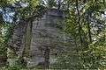 |
Vers-le-Château, Medieval Village | 574.870 | 176.690 | 46°44′27″N 7°06′35″E / 46.740926°N 7.109813°E |
Attalens
| KGS No.? |
Picture | Name | Street Address | CH1903 X coordinate | CH1903 Y coordinate | Location |
|---|---|---|---|---|---|---|
| 1937 |  |
Notre-Dame De L'Assomption Church | Rue De L’Eglise 7 | 554.760 | 151.230 | 46°30′39″N 6°50′57″E / 46.510845°N 6.849185°E |
Barberêche
| KGS No.? |
Picture | Name | Street Address | CH1903 X coordinate | CH1903 Y coordinate | Location |
|---|---|---|---|---|---|---|
| 1945 | 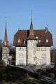 |
Grand-Vivy Castle | Grand-Vivy 1 | 580.030 | 191.139 | 46°52′16″N 7°10′36″E / 46.871074°N 7.1767°E |
| 1943 | 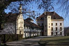 |
Barberêche Castle | Le Château 1 | 579.192 | 189.672 | 46°51′28″N 7°09′57″E / 46.857853°N 7.165775°E |
| 1946 | 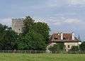 |
Petit-Vivy Castle | Petit-Vivy 4 | 579.689 | 190.545 | 46°51′57″N 7°10′20″E / 46.865721°N 7.172253°E |
| 9943 | 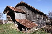 |
Barn and stable | Chemin de la Fruiterie 5 A | 578.587 | 189.624 | 46°51′27″N 7°09′28″E / 46.857402°N 7.157844°E |
| 9944 | Granary | Route de Grimoine 20 B | 580.368 | 191.804 | 46°52′37″N 7°10′52″E / 46.877066°N 7.181104°E | |
| Unknown | ISOS cas particulier: Petit et Grand-Vivy |
Bas-Intyamon
| KGS No.? |
Picture | Name | Street Address | CH1903 X coordinate | CH1903 Y coordinate | Location |
|---|---|---|---|---|---|---|
| Unknown | ISOS village: Estavannens | |||||
| Unknown | ISOS village: Villars-sous-Mont |
Belfaux
| KGS No.? |
Picture | Name | Street Address | CH1903 X coordinate | CH1903 Y coordinate | Location |
|---|---|---|---|---|---|---|
| 1947 | 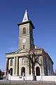 |
Saint-Etienne Church | Route Du Centre 10 | 574.673 | 185.738 | 46°49′20″N 7°06′24″E / 46.822309°N 7.106734°E |
| 1951 |  |
Mansion de Lanthen-Heid | Route du Centre 35 | 574.330 | 185.793 | 46°49′22″N 7°06′08″E / 46.82279°N 7.102237°E |
Belmont-Broye
| KGS No.? |
Picture | Name | Street Address | CH1903 X coordinate | CH1903 Y coordinate | Location |
|---|---|---|---|---|---|---|
| 2215 | 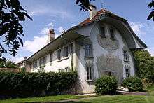 |
Mansion De Gottrau | Route De Payerne 5 | 567.715 | 186.442 | 46°49′42″N 7°00′56″E / 46.82834°N 7.015504°E |
| Unknown | ISOS village: Dompierre (FR) |
Bösingen
| KGS No.? |
Picture | Name | Street Address | CH1903 X coordinate | CH1903 Y coordinate | Location |
|---|---|---|---|---|---|---|
| 11695 | .jpg) |
Gallo-Roman Complex | Dorf | 583.960 | 193.650 | 46°53′38″N 7°13′41″E / 46.893768°N 7.228159°E |
| 1959 |  |
Landsitz von Vogelshus | Vogelshaus 79-81 | 582.668 | 191.603 | 46°52′31″N 7°12′41″E / 46.875322°N 7.211283°E |
| Unknown | ISOS Dorf: Bösingen | |||||
| Unknown | ISOS Weiler: Richterwil |
Bossonnens
| KGS No.? |
Picture | Name | Street Address | CH1903 X coordinate | CH1903 Y coordinate | Location |
|---|---|---|---|---|---|---|
| 1960 | 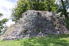 |
Ruins of Bossonnens Castle | 554.710 | 152.320 | 46°31′14″N 6°50′54″E / 46.520646°N 6.848427°E |
Broc
| KGS No.? |
Picture | Name | Street Address | CH1903 X coordinate | CH1903 Y coordinate | Location |
|---|---|---|---|---|---|---|
| 1961 | 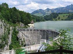 |
Montsalvens Dam (Shared With Châtel-sur-Montsalvens) | 576.570 | 162.387 | 46°36′44″N 7°07′58″E / 46.612326°N 7.132786°E | |
| 9946 | 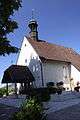 |
Notre-Dame des Marches Chapel | Route des Marches 14 | 574.182 | 160.218 | 46°35′34″N 7°06′06″E / 46.592727°N 7.101736°E |
| Unknown | ISOS cas particulier: Broc-Fabrique | |||||
| Unknown | ISOS cas particulier: Broc-Vieille Cure |
Bulle
| KGS No.? |
Picture | Name | Street Address | CH1903 X coordinate | CH1903 Y coordinate | Location |
|---|---|---|---|---|---|---|
| 1968 | 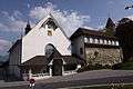 |
Notre-Dame De Compassion Chapel | Rue Du Marché 2 A, 4 | 570.867 | 163.044 | 46°37′05″N 7°03′30″E / 46.618012°N 7.0583°E |
| 1965 | 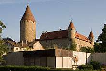 |
Baillival Castle | Place du Tilleul 1 | 570.838 | 162.995 | 46°37′03″N 7°03′29″E / 46.61757°N 7.057924°E |
| 9059 | 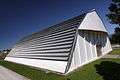 |
Halle Landi | Route de la Pâla 101 A | 569.450 | 162.830 | 46°36′58″N 7°02′23″E / 46.616024°N 7.039815°E |
| 8661 |  |
Gruérien Museum | Rue de la Condémine 25 | 570.889 | 162.898 | 46°37′00″N 7°03′31″E / 46.6167°N 7.058596°E |
| Unknown | ISOS petite Village / bourg: Bulle |
Bussy
| KGS No.? |
Picture | Name | Street Address | CH1903 X coordinate | CH1903 Y coordinate | Location |
|---|---|---|---|---|---|---|
| 9728 |  |
Church Saint-Maurice | Route Des Baudèzes 4 | 558.097 | 187.218 | 46°50′05″N 6°53′22″E / 46.834785°N 6.889381°E |
| Unknown | ISOS village: Bussy (FR) |
Châbles
| KGS No.? |
Picture | Name | Street Address | CH1903 X coordinate | CH1903 Y coordinate | Location |
|---|---|---|---|---|---|---|
| Unknown | ISOS cas particulier: Font shared between Châbles and Font |
Châtel-Saint-Denis
| KGS No.? |
Picture | Name | Street Address | CH1903 X coordinate | CH1903 Y coordinate | Location |
|---|---|---|---|---|---|---|
| 1985 | 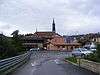 |
Saint-Denis Church | Chemin De L’Eglise 31 | 558.771 | 153.189 | 46°31′43″N 6°54′05″E / 46.528726°N 6.901269°E |
| Unknown | ISOS petite Village / bourg: Châtel-Saint-Denis | |||||
| Unknown | ISOS hameau: Prayoud |
Châtel-sur-Montsalvens
| KGS No.? |
Picture | Name | Street Address | CH1903 X coordinate | CH1903 Y coordinate | Location |
|---|---|---|---|---|---|---|
| 1989 | |
Montsalvens Dam (Shared With Broc) | 576.570 | 162.387 | 46°36′44″N 7°07′58″E / 46.612326°N 7.132786°E |
Châtillon
| KGS No.? |
Picture | Name | Street Address | CH1903 X coordinate | CH1903 Y coordinate | Location |
|---|---|---|---|---|---|---|
| 9595 | La Vuardaz Gallo-Roman Villa |
553.500 | 187.275 | 46°50′06″N 6°49′45″E / 46.834992°N 6.829121°E |
Cheiry
| KGS No.? |
Picture | Name | Street Address | CH1903 X coordinate | CH1903 Y coordinate | Location |
|---|---|---|---|---|---|---|
| 9948 |  |
Granary | Route Du Centre 21 A | 553.863 | 177.813 | 46°45′00″N 6°50′05″E / 46.749905°N 6.834833°E |
Corbières
| KGS No.? |
Picture | Name | Street Address | CH1903 X coordinate | CH1903 Y coordinate | Location |
|---|---|---|---|---|---|---|
| 1995 | 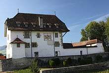 |
Baillival Castle | Impasse De La Ville 5 | 574.036 | 167.733 | 46°39′37″N 7°05′58″E / 46.660322°N 7.099407°E |
| Unknown | ISOS cas particulier: Corbières |
Corminboeuf
| KGS No.? |
Picture | Name | Street Address | CH1903 X coordinate | CH1903 Y coordinate | Location |
|---|---|---|---|---|---|---|
| 1999 |  |
Granary of De Schaller Farm | Route Du Centre 4A | 574.516 | 184.229 | 46°48′31″N 7°06′17″E / 46.808729°N 7.104761°E |
| 10471 | |
Parc «Bois Murat» | Le Bugnon | 573.789 | 182.254 | 46°47′27″N 7°05′43″E / 46.790935°N 7.09535°E |
Cottens
| KGS No.? |
Picture | Name | Street Address | CH1903 X coordinate | CH1903 Y coordinate | Location |
|---|---|---|---|---|---|---|
| 2000 | 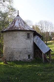 |
Granary | Route De Fribourg 1 A | 568.742 | 177.725 | 46°45′00″N 7°01′46″E / 46.749977°N 7.029559°E |
Cressier
| KGS No.? |
Picture | Name | Street Address | CH1903 X coordinate | CH1903 Y coordinate | Location |
|---|---|---|---|---|---|---|
| 2003 |  |
Mansion De Reynold | Route Du Moos 1 | 577.217 | 194.224 | 46°53′55″N 7°08′23″E / 46.898734°N 7.139649°E |
| Unknown | ISOS village: Cressier (FR) |
Cugy
| KGS No.? |
Picture | Name | Street Address | CH1903 X coordinate | CH1903 Y coordinate | Location |
|---|---|---|---|---|---|---|
| 2008 |  |
Saint-Martin Church | Grand-Rue 59 A | 558.351 | 185.005 | 46°48′54″N 6°53′34″E / 46.814894°N 6.892912°E |
Delley-Portalban
| KGS No.? |
Picture | Name | Street Address | CH1903 X coordinate | CH1903 Y coordinate | Location |
|---|---|---|---|---|---|---|
| 2011 | 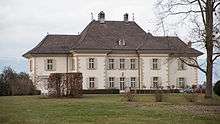 |
Castella Castle | Delley, Route De Portalban 40–40 A | 564.141 | 196.198 | 46°54′57″N 6°58′04″E / 46.915914°N 6.967896°E |
Düdingen
| KGS No.? |
Picture | Name | Street Address | CH1903 X coordinate | CH1903 Y coordinate | Location |
|---|---|---|---|---|---|---|
| 2016 | 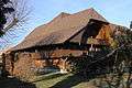 |
Farm House | Galmis 6 | 582.879 | 189.785 | 46°51′32″N 7°12′51″E / 46.858974°N 7.214119°E |
| 2015 |  |
Former Hermitage of St. Magdalena | Räsch | 578.244 | 186.916 | 46°49′59″N 7°09′13″E / 46.833031°N 7.153475°E |
| 10505 |  |
Grandfey-Viadukt (Shared with Granges-Paccot) | 579.335 | 186.170 | 46°49′35″N 7°10′04″E / 46.826356°N 7.167808°E | |
| 2018 |  |
Landsitz de Boccard | Jetschwil 15 | 581.843 | 187.206 | 46°50′09″N 7°12′02″E / 46.835748°N 7.200636°E |
| 10149 | 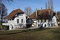 |
Landsitz von Montenach | Balliswil 3, 5 | 579.826 | 186.406 | 46°49′43″N 7°10′27″E / 46.828494°N 7.174233°E |
| 2022 |  |
Pilgrimage Chapel | St. Wolfgang 25 | 580.748 | 186.553 | 46°49′47″N 7°11′11″E / 46.829843°N 7.186311°E |
| 2020 |  |
Pilgrimage Chapel of Our Lady | Mariahilf 7 | 582.143 | 186.479 | 46°49′45″N 7°12′17″E / 46.829216°N 7.204597°E |
| Unknown | ISOS Weiler: Galmis | |||||
| Unknown | ISOS Weiler: Jetschwil |
Echarlens
| KGS No.? |
Picture | Name | Street Address | CH1903 X coordinate | CH1903 Y coordinate | Location |
|---|---|---|---|---|---|---|
| 9952 | 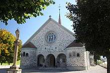 |
Notre-Dame De L’Assomption Church | Au Village 203 | 572.192 | 166.367 | 46°38′53″N 7°04′31″E / 46.64796°N 7.075397°E |
Estavayer-le-Lac
| KGS No.? |
Picture | Name | Street Address | CH1903 X coordinate | CH1903 Y coordinate | Location |
|---|---|---|---|---|---|---|
| 2038 |  |
De Rivaz Chapel | Grand-Rue 44 | 554.765 | 188.901 | 46°50′59″N 6°50′44″E / 46.849705°N 6.845541°E |
| Unknown |  |
Sacré-Coeur Chapel | Chemin du Sacré-Coeur 2 | 554.957 | 188.635 | 46°50′50″N 6°50′53″E / 46.847326°N 6.848084°E |
| 2031 |  |
Chenaux Castle | Chemin du Donjon 1 | 555.015 | 189.100 | 46°51′05″N 6°50′56″E / 46.851512°N 6.848799°E |
| 2032 |  |
Collegiate church of Saint-Laurent | Place de l’Eglise 1 | 554.876 | 188.921 | 46°51′00″N 6°50′49″E / 46.849893°N 6.846994°E |
| 2033 |  |
Convent of the Dominican nuns | Grand-Rue 3 | 554.981 | 188.772 | 46°50′55″N 6°50′54″E / 46.848559°N 6.848385°E |
| 2034 |  |
Fortifications | 554.900 | 188.900 | 46°50′59″N 6°50′50″E / 46.849705°N 6.847311°E | |
| 2035 |  |
House de la Dîme | Rue du Musée 13 | 555.007 | 188.876 | 46°50′58″N 6°50′55″E / 46.849497°N 6.848716°E |
| 2047 |  |
House des Sires d’Estavayer | Impasse de Motte-Châtel 8 | 554.840 | 188.981 | 46°51′02″N 6°50′47″E / 46.85043°N 6.846516°E |
| 9596 | La Vuardaz Gallo-Roman Villa |
Font village | 553.500 | 187.275 | 46°50′06″N 6°49′45″E / 46.834992°N 6.829121°E | |
| Unknown | ISOS petite Village / bourg: Estavayer-le-Lac | |||||
| Unknown | ISOS cas particulier: Font (shared between Châbles and Font) |
Fribourg
| KGS No.? |
Picture | Name | Street Address | CH1903 X coordinate | CH1903 Y coordinate | Location |
|---|---|---|---|---|---|---|
| 2063, 9298 |  |
Cistercians Maigrauge Abbey with Library | Chemin de l’Abbaye 2–8 | 578.619 | 183.222 | 46°47′59″N 7°09′31″E / 46.799815°N 7.158563°E |
| 2077 |  |
Former Convent of the Augustinians | Rue des Augustins 1 / Chemin | 579.252 | 183.760 | 46°48′17″N 7°10′01″E / 46.804674°N 7.16683°E |
| 2131 |  |
Former Hôtel des Postes et Télégraphes | Square des Places 3 | 578.402 | 183.727 | 46°48′16″N 7°09′21″E / 46.80435°N 7.155696°E |
| 2076 |  |
Former Commandry de Saint-Jean | Planche-Supérieure 3 & 9 | 578.953 | 183.577 | 46°48′11″N 7°09′47″E / 46.803019°N 7.162922°E |
| 8824 |  |
Archives of the State of Fribourg | Route des Arsenaux 17 | 577.966 | 183.042 | 46°47′53″N 7°09′00″E / 46.798174°N 7.150018°E |
| 8861 |  |
Archives of the City of Fribourg | Rue des Chanoines 1 | 578.969 | 183.968 | 46°48′24″N 7°09′47″E / 46.806536°N 7.163113°E |
| 2105 |  |
Auberge de la Cigogne | Rue d’Or 24 | 579.363 | 183.678 | 46°48′14″N 7°10′06″E / 46.80394°N 7.168288°E |
| 2117 |  |
Notre-Dame Basilica | Place de Notre-Dame 1 | 578.858 | 184.010 | 46°48′25″N 7°09′42″E / 46.806911°N 7.161657°E |
| 2065, 9327, 8926 |  |
Cantonal and University Library | Rue Joseph-Piller 2 | 578.432 | 183.969 | 46°48′24″N 7°09′22″E / 46.806528°N 7.156078°E |
| 2067, 8663 |  |
Saint-Nicolas Cathedral and the Treasury | Rue de la Cathédrale Saint-Nicolas 7 | 578.964 | 183.927 | 46°48′22″N 7°09′47″E / 46.806167°N 7.16305°E |
| 2176 |  |
Maigrauge power station | Promenade du Barrage 5 | 579.158 | 183.063 | 46°47′54″N 7°09′56″E / 46.798402°N 7.16563°E |
| 2116 |  |
Centre paroissial du Christe-Roi | Boulevard de Pérolles 45 | 578.271 | 182.889 | 46°47′49″N 7°09′14″E / 46.796808°N 7.15402°E |
| 9261 |  |
Cercle de la Grande Société | Grand-Rue 68 | 578.857 | 183.880 | 46°48′21″N 7°09′42″E / 46.805741°N 7.16165°E |
| 2112 |  |
Chancellerie de l’Etat | Rue des Chanoines 17 | 579.047 | 183.927 | 46°48′22″N 7°09′51″E / 46.80617°N 7.164137°E |
| 2068 |  |
Loreto Chapel | Chemin de Lorette 3 | 579.203 | 183.353 | 46°48′04″N 7°09′58″E / 46.801012°N 7.166207°E |
| 2069 |  |
Saint-Barthélemy Chapel (Pérolles Chapel) | Avenue du Midi 41 | 577.630 | 183.020 | 46°47′53″N 7°08′44″E / 46.797965°N 7.145618°E |
| 2070 |  |
Poya Castle | Rue de Morat 44–48 | 578.700 | 184.775 | 46°48′50″N 7°09′34″E / 46.813787°N 7.159551°E |
| 2072 |  |
Collège Saint-Michel | Rue Saint-Pierre-Canisius 6–10, 20 | 578.571 | 183.983 | 46°48′24″N 7°09′28″E / 46.806659°N 7.157898°E |
| 2073 |  |
Convent of the Capucins | Rue de Morat 28–32 | 578.645 | 184.393 | 46°48′37″N 7°09′32″E / 46.810349°N 7.158849°E |
| 2074, 8907, 9328 |  |
Convent of the Cordeliers | Archives et Bibliothèque, Rue de Morat 6 | 578.777 | 184.078 | 46°48′27″N 7°09′38″E / 46.80752°N 7.160593°E |
| 2075 |  |
Convent of the Ursulines | Rue de Lausanne 90–92 | 578.480 | 183.776 | 46°48′17″N 7°09′24″E / 46.804794°N 7.156716°E |
| 2164 |  |
Cure | Rue de la Lenda 1 | 579.185 | 183.738 | 46°48′16″N 7°09′57″E / 46.804474°N 7.165953°E |
| 9960 |  |
Church Saint-Pierre | Avenue Jean-Gambach 6 | 577.738 | 183.584 | 46°48′11″N 7°08′49″E / 46.803042°N 7.147005°E |
| 2120 |  |
Factory Complex de Chocolats Villars | Route de la Fonderie 2, 6 | 578.269 | 182.616 | 46°47′40″N 7°09′14″E / 46.794352°N 7.154007°E |
| 2121 |  |
Fountain of Fidelity | Rue des Forgerons | 579.456 | 183.738 | 46°48′16″N 7°10′10″E / 46.804483°N 7.169504°E |
| 2122 |  |
Fountain of Force | Escaliers du Court-Chemin | 578.786 | 183.734 | 46°48′16″N 7°09′39″E / 46.804426°N 7.160727°E |
| 2123 |  |
Fountain of Samaritaine | Rue de la Samaritaine | 579.279 | 183.647 | 46°48′13″N 7°10′02″E / 46.803659°N 7.167189°E |
| 2124 |  |
Fountain of Vaillance | Rue des Chanoines | 579.009 | 183.910 | 46°48′22″N 7°09′49″E / 46.806016°N 7.16364°E |
| 2130 |  |
Fountain of Sainte-Anne | Place du Petit-Saint-Jean | 579.297 | 183.633 | 46°48′13″N 7°10′03″E / 46.803533°N 7.167425°E |
| 2126 |  |
Fountain of Saint-Georges | Place de l’Hôtel-de-Ville | 578.803 | 183.862 | 46°48′20″N 7°09′39″E / 46.805578°N 7.160943°E |
| 2127 |  |
Fountain of Saint-Jean | Planche-Supérieure | 578.951 | 183.543 | 46°48′10″N 7°09′46″E / 46.802713°N 7.162897°E |
| 2125 |  |
Fountain of Samson | Place de Notre-Dame | 578.859 | 183.985 | 46°48′24″N 7°09′42″E / 46.806686°N 7.161671°E |
| 2082 |  |
Fountain Jo Siffert | Grand-Places | 578.280 | 183.500 | 46°48′08″N 7°09′15″E / 46.802304°N 7.154109°E |
| 2098 |  |
Fortifications | 579.000 | 184.000 | 46°48′25″N 7°09′49″E / 46.806825°N 7.163518°E | |
| 10131 |  |
Funiculaire Neuveville-Saint-Pierre | 578.534 | 183.673 | 46°48′14″N 7°09′27″E / 46.803869°N 7.157428°E | |
| 2064, 8690 |  |
Derrière-Notre-Dame Granary and Museum Gutenberg, Museum suisse des arts graphiques et |
Place de Notre-Dame 16 | 578.877 | 184.051 | 46°48′26″N 7°09′43″E / 46.80728°N 7.161904°E |
| 2100, 11593 |  |
De la Planche Granary | Planche-Supérieure 13 | 579.023 | 183.532 | 46°48′09″N 7°09′50″E / 46.802616°N 7.163841°E |
| 9405 |  |
House | Rue de la Neuveville 48 | 578.796 | 183.704 | 46°48′15″N 7°09′39″E / 46.804156°N 7.160859°E |
| 9406 |  |
House | Rue d’Or 7 | 579.318 | 183.695 | 46°48′15″N 7°10′04″E / 46.804092°N 7.167698°E |
| 2131 |  |
Hospital of the Bourgeois | Rue de l’Hôpital 2 | 578.305 | 183.857 | 46°48′20″N 7°09′16″E / 46.805517°N 7.15442°E |
| 2084 |  |
City Hall | Place de l’Hôtel-de-Ville 2 | 578.809 | 183.838 | 46°48′19″N 7°09′40″E / 46.805362°N 7.161023°E |
| 2085, 8662 |  |
Hôtel Ratzé et Museum d’art et d’histoire | Rue de Morat 12-14 | 578.700 | 184.104 | 46°48′28″N 7°09′34″E / 46.807751°N 7.159583°E |
| 9407 |  |
Immeuble de rapport Sallin | Boulevard de Pérolles 39 | 578.257 | 182.953 | 46°47′51″N 7°09′14″E / 46.797383°N 7.153834°E |
| 9277 |  |
Les Arcades | Place des Ormeaux 1 | 578.803 | 183.936 | 46°48′22″N 7°09′39″E / 46.806243°N 7.16094°E |
| 2091 |  |
House | Rue d’Or 13 | 579.338 | 183.702 | 46°48′15″N 7°10′05″E / 46.804155°N 7.167959°E |
| 9100 |  |
House d’Alt | Place de l’Hôtel-de-Ville 1 | 578.834 | 183.879 | 46°48′21″N 7°09′41″E / 46.805732°N 7.161349°E |
| 9408 |  |
De Castella House | Rue Pierre-Aeby 3 | 578.770 | 183.953 | 46°48′23″N 7°09′38″E / 46.806395°N 7.160507°E |
| 2086 |  |
House of Fégely-d’Estavayer dite Vicarino | 578.571 | 183.778 | 46°48′17″N 7°09′28″E / 46.804815°N 7.157908°E | |
| 2087 |  |
House of François-Prosper de Castella | Grand-Rue 55 | 578.988 | 183.867 | 46°48′20″N 7°09′48″E / 46.805628°N 7.163367°E |
| 2155 |  |
House of Gottrau dite Les Tornalettes | Grand-Rue 67 | 578.892 | 183.881 | 46°48′21″N 7°09′44″E / 46.805751°N 7.162108°E |
| 2135 |  |
House of Jean-François d’Ammann de Macconens | 578.939 | 183.880 | 46°48′21″N 7°09′46″E / 46.805744°N 7.162724°E | |
| 2146 |  |
House de Lanthen-Heid | Grand-Rue 56 | 578.974 | 183.870 | 46°48′20″N 7°09′47″E / 46.805655°N 7.163183°E |
| 2160 |  |
Reyff House | Grand-Rue 10 | 578.883 | 183.841 | 46°48′19″N 7°09′43″E / 46.805391°N 7.161992°E |
| 2089 |  |
Reyff de Cugy House | Grand-Rue 14 | 578.919 | 183.843 | 46°48′19″N 7°09′45″E / 46.80541°N 7.162464°E |
| 2090 |  |
Techtermann House | Rue de Zaehringen 13 | 579.145 | 183.792 | 46°48′18″N 7°09′56″E / 46.804959°N 7.165427°E |
| 2154 | 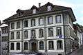 |
Nicolas Kuenlin House | Rue des Augustins 2 | 579.211 | 183.731 | 46°48′16″N 7°09′59″E / 46.804412°N 7.166294°E |
| 2149 |  |
House of tanners Reyff | Rue de la Samaritaine 16 | 579.230 | 183.673 | 46°48′14″N 7°10′00″E / 46.803891°N 7.166546°E |
| 9958 |  |
House Fégely (?) dite tannerie Deillon | 578.790 | 183.704 | 46°48′15″N 7°09′39″E / 46.804156°N 7.16078°E | |
| 2092 |  |
The Visitation Monastery | Rue de Morat 16–18 | 578.655 | 184.177 | 46°48′30″N 7°09′32″E / 46.808406°N 7.15899°E |
| 2093 |  |
Monastery of the Capucines de Montorge | Chemin de Lorette 8–10 | 578.864 | 183.339 | 46°48′03″N 7°09′42″E / 46.800875°N 7.161767°E |
| 9263 |  |
Piscine de la Motta | Chemin des Bains 8 | 578.650 | 183.498 | 46°48′08″N 7°09′32″E / 46.802298°N 7.158956°E |
| 2094 |  |
Pont de Berne | Place du Petit-Saint-Jean / Rue des | 579.417 | 183.715 | 46°48′15″N 7°10′08″E / 46.804275°N 7.168994°E |
| 2095 | |
Pont de Saint-Jean | Rue de la Neuveville / Planche-Supérieure | 578.880 | 183.620 | 46°48′12″N 7°09′43″E / 46.803403°N 7.161963°E |
| 9409 |  |
Pont du Gottéron | Route de Bourguillon | 579.636 | 183.727 | 46°48′16″N 7°10′19″E / 46.804389°N 7.171862°E |
| 2096 |  |
Pont du Milieu | Planche-Inférieure / Place du Petit-Saint-Jean | 579.292 | 183.530 | 46°48′09″N 7°10′03″E / 46.802607°N 7.167365°E |
| 2097 |  |
Université Miséricorde | Avenue de l’Europe 20 | 578.105 | 183.936 | 46°48′22″N 7°09′06″E / 46.806221°N 7.151796°E |
| 9597 |  |
Old City | 579.128 | 183.863 | 46°48′20″N 7°09′55″E / 46.805597°N 7.165201°E | |
| 9965 | 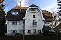 |
Villa Mayer | Avenue Jean-Gambach 24 | 577.916 | 183.850 | 46°48′20″N 7°08′58″E / 46.805441°N 7.149324°E |
| Unknown |  |
ISOS ville: Fribourg | ||||
| Unknown | ISOS cas particulier: Bourguillon | |||||
| Unknown | ISOS cas particulier: Vallon du Gottéron |
Gibloux
| KGS No.? |
Picture | Name | Street Address | CH1903 X coordinate | CH1903 Y coordinate | Location |
|---|---|---|---|---|---|---|
| 9955 |  |
Chapel Notre-Dame | Posat, Chemin de la Glâne 10 | 570.535 | 176.075 | 46°44′07″N 7°03′11″E / 46.735217°N 7.05313°E |
| 2061 |  |
Church Saint-Vincent | Farvagny-le-Grand, | 571.530 | 174.600 | 46°43′19″N 7°03′58″E / 46.721992°N 7.06624°E |
| 2303 |  |
Ruins of Illens Castle | Auge Du Château | 574.920 | 176.430 | 46°44′19″N 7°06′38″E / 46.738589°N 7.110481°E |
Givisiez
| KGS No.? |
Picture | Name | Street Address | CH1903 X coordinate | CH1903 Y coordinate | Location |
|---|---|---|---|---|---|---|
| 2179 |  |
Mansion D’Affry Et Atelier De La Sculptrice Marcello | Place D’Affry 7 | 576.305 | 184.690 | 46°48′47″N 7°07′41″E / 46.812942°N 7.128175°E |
Grandvillard
| KGS No.? |
Picture | Name | Street Address | CH1903 X coordinate | CH1903 Y coordinate | Location |
|---|---|---|---|---|---|---|
| 9966 | 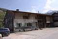 |
Farm House | Route De La Grande-Charrière 32 | 573.056 | 154.517 | 46°32′29″N 7°05′15″E / 46.541399°N 7.087376°E |
| 2182 | 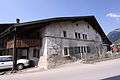 |
House | Route de la Gare 10 | 572.866 | 154.499 | 46°32′28″N 7°05′06″E / 46.54123°N 7.0849°E |
| 9967 |  |
House of the Counts | Rue Saint-Jacques 25 | 572.911 | 154.370 | 46°32′24″N 7°05′08″E / 46.540071°N 7.085494°E |
| 2184 | 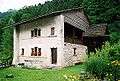 |
Banneret House | Chemin Pierre-de-la-Tinaz 2 | 573.162 | 153.987 | 46°32′12″N 7°05′20″E / 46.536636°N 7.088788°E |
| 9969 | 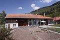 |
Rangée d’habitations et ruraux | Route du Banneret 49–51 | 573.087 | 154.074 | 46°32′15″N 7°05′16″E / 46.537415°N 7.087806°E |
| Unknown | ISOS village: Grandvillard |
Granges-Paccot
| KGS No.? |
Picture | Name | Street Address | CH1903 X coordinate | CH1903 Y coordinate | Location |
|---|---|---|---|---|---|---|
| 9076 | |
Viaduc De Grandfey (Shared With Düdingen) | 579.335 | 186.175 | 46°49′35″N 7°10′04″E / 46.826401°N 7.167808°E |
Greng
| KGS No.? |
Picture | Name | Street Address | CH1903 X coordinate | CH1903 Y coordinate | Location |
|---|---|---|---|---|---|---|
| 9598 |  |
Grengspitz | Station Lacustre | 573.450 | 196.700 | 46°55′15″N 7°05′24″E / 46.920867°N 7.09007°E |
| 9970 |  |
Turmspeicher | Bureliweg 1 A | 573.793 | 195.677 | 46°54′42″N 7°05′41″E / 46.911678°N 7.094632°E |
Gruyères
| KGS No.? |
Picture | Name | Street Address | CH1903 X coordinate | CH1903 Y coordinate | Location |
|---|---|---|---|---|---|---|
| 2196 |  |
Former Chartreuse De La Part-Dieu | La Part-Dieu 306 | 567.684 | 160.725 | 46°35′49″N 7°01′01″E / 46.597005°N 7.016909°E |
| 2192, 8689 | 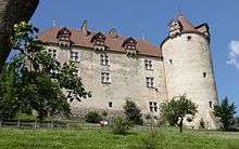 |
Gruyères Castle | Rue du Château 10 | 572.818 | 159.327 | 46°35′05″N 7°05′02″E / 46.584658°N 7.08399°E |
| 2198 |  |
Saint-Germain Castle | Rue du Château 2 | 572.696 | 159.260 | 46°35′03″N 7°04′57″E / 46.58405°N 7.082402°E |
| 2194 |  |
Fortifications | 572.600 | 159.140 | 46°34′59″N 7°04′52″E / 46.582967°N 7.081156°E | |
| 9972 |  |
Grange du Laviau | Route de Saussivue 73 A | 572.751 | 158.854 | 46°34′49″N 7°04′59″E / 46.5804°N 7.083143°E |
| 9476 |  |
House | Rue du Bourg 7 | 572.550 | 159.174 | 46°35′00″N 7°04′50″E / 46.583271°N 7.080502°E |
| 9477 |  |
House | Rue du Bourg 39 | 572.622 | 159.239 | 46°35′02″N 7°04′53″E / 46.583858°N 7.081438°E |
| 2193 |  |
House known as Chalamala | Rue du Bourg 47 | 572.644 | 159.265 | 46°35′03″N 7°04′54″E / 46.584093°N 7.081723°E |
| Unknown | ISOS petite Village / bourg: Gruyères | |||||
| Unknown | ISOS cas particulier: La Part-Dieu |
Hauterive
| KGS No.? |
Picture | Name | Street Address | CH1903 X coordinate | CH1903 Y coordinate | Location |
|---|---|---|---|---|---|---|
| 2273 | 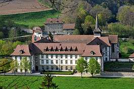 |
Cistercian Abbey of Hauterive | Chemin De L’Abbaye 17–19 | 575.487 | 179.252 | 46°45′50″N 7°07′04″E / 46.763995°N 7.117749°E |
| 2275 |  |
Votive Chapel of Sacré-Coeur | Route de Matran 29 | 573.740 | 179.076 | 46°45′44″N 7°05′42″E / 46.762346°N 7.09489°E |
| 2272 | Châtillon-sur-Glâne, the iron age settlement | 576.210 | 181.380 | 46°46′59″N 7°07′38″E / 46.783164°N 7.127103°E | ||
| 10501 |  |
Glâne Bridge(Shared with Villars-sur-Glâne) | 576.147 | 181.576 | 46°47′06″N 7°07′35″E / 46.784924°N 7.126268°E | |
| 2274 |  |
Bridge and Chapel of Sainte-Apolline (Shared with Villars-sur-Glâne / FR) | 575.401 | 181.510 | 46°47′03″N 7°06′59″E / 46.784304°N 7.116502°E | |
| Unknown | ISOS cas particulier: Hauterive (FR) |
Hauteville
| KGS No.? |
Picture | Name | Street Address | CH1903 X coordinate | CH1903 Y coordinate | Location |
|---|---|---|---|---|---|---|
| 9974 | 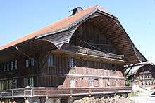 |
Farm House | Route De L’Eglise 47 | 574.447 | 168.826 | 46°40′13″N 7°06′17″E / 46.67017°N 7.104716°E |
Haut-Intyamon
| KGS No.? |
Picture | Name | Street Address | CH1903 X coordinate | CH1903 Y coordinate | Location |
|---|---|---|---|---|---|---|
| 2236 |  |
Former Auberge De La Croix-Blanche À Montbovon | Village 10 | 569.774 | 148.607 | 46°29′17″N 7°02′42″E / 46.488096°N 7.044976°E |
| 1929 |  |
Chalet d’alpage | Albeuve, En Lys 215 | 566.061 | 149.758 | 46°29′54″N 6°59′48″E / 46.498272°N 6.996535°E |
| 9976 |  |
Farm House | Montbovon, Bellegardes 207 A | 570.095 | 148.983 | 46°29′29″N 7°02′57″E / 46.491492°N 7.049133°E |
| 2217 |  |
Fountain | Lessoc, Au Village 66 | 571.100 | 150.463 | 46°30′17″N 7°03′44″E / 46.50485°N 7.06213°E |
| 9977 |  |
House de François Fracheboud | Lessoc, Au Village 18 | 571.129 | 150.415 | 46°30′16″N 7°03′45″E / 46.504419°N 7.062511°E |
| Unknown | ISOS village: Lessoc | |||||
| Unknown | ISOS village: Neirivue | |||||
| Unknown | ISOS cas particulier: Montbovon |
Heitenried
| KGS No.? |
Picture | Name | Street Address | CH1903 X coordinate | CH1903 Y coordinate | Location |
|---|---|---|---|---|---|---|
| 2204 |  |
Parish Church of St. Michael | Dorfstrasse 30 | 589.436 | 186.278 | 46°49′39″N 7°18′01″E / 46.827564°N 7.300186°E |
Jaun
| KGS No.? |
Picture | Name | Street Address | CH1903 X coordinate | CH1903 Y coordinate | Location |
|---|---|---|---|---|---|---|
| 2212 | 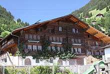 |
Statthalter House | Dorfstrasse 15–17 | 587.555 | 162.270 | 46°36′42″N 7°16′34″E / 46.611568°N 7.276185°E |
| 9980 | 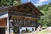 |
Farm House | Jaunpassstrasse 5 | 588.571 | 162.169 | 46°36′38″N 7°17′22″E / 46.610678°N 7.28945°E |
| Unknown | ISOS Dorf: Jaun |
Kerzers
| KGS No.? |
Picture | Name | Street Address | CH1903 X coordinate | CH1903 Y coordinate | Location |
|---|---|---|---|---|---|---|
| 9481 |  |
Stellwerk (Signal House at the Train Station) |
Bahnhofplatz 1 C | 581.267 | 202.692 | 46°58′30″N 7°11′33″E / 46.975032°N 7.192449°E |
| Unknown | ISOS Verstädtertes Dorf: Kerzers |
La Roche
| KGS No.? |
Picture | Name | Street Address | CH1903 X coordinate | CH1903 Y coordinate | Location |
|---|---|---|---|---|---|---|
| 2292 | 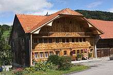 |
Farm House | Vers Les Roulin 52 | 577.806 | 172.506 | 46°42′12″N 7°08′54″E / 46.703393°N 7.148432°E |
La Verrerie
| KGS No.? |
Picture | Name | Street Address | CH1903 X coordinate | CH1903 Y coordinate | Location |
|---|---|---|---|---|---|---|
| 2006 |  |
Church Saint-Loup | Le Crêt, Le Crêt 1 | 559.500 | 162.111 | 46°36′32″N 6°54′36″E / 46.609027°N 6.909987°E |
Le Mouret
| KGS No.? |
Picture | Name | Street Address | CH1903 X coordinate | CH1903 Y coordinate | Location |
|---|---|---|---|---|---|---|
| 2277 |  |
Former Mineral Baths | Praroman, Route De L’Eglise 72 | 580.096 | 177.829 | 46°45′05″N 7°10′41″E / 46.751348°N 7.178145°E |
| 9992 | 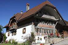 |
Farm House | Praroman, Route de l'Eglise 57 | 579.952 | 177.805 | 46°45′04″N 7°10′35″E / 46.751128°N 7.176261°E |
| Unknown | ISOS cas particulier: La Riedera |
Les Montets
| KGS No.? |
Picture | Name | Street Address | CH1903 X coordinate | CH1903 Y coordinate | Location |
|---|---|---|---|---|---|---|
| 2242 | 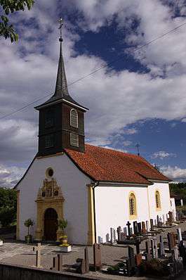 |
Paroissiale De La Sainte-Trinité Church | Montet, Au Village 8 | 556.508 | 185.141 | 46°48′58″N 6°52′08″E / 46.816°N 6.868751°E |
Marsens
| KGS No.? |
Picture | Name | Street Address | CH1903 X coordinate | CH1903 Y coordinate | Location |
|---|---|---|---|---|---|---|
| 2355 | 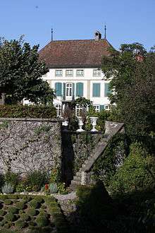 |
Baillival Castle | Vuippens, Rue Des Châteaux 27 | 572.400 | 167.520 | 46°39′30″N 7°04′41″E / 46.658341°N 7.078045°E |
| 2223 | 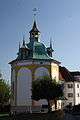 |
Saint-Ignace Chapel | Route de la Rotonde 20 | 571.385 | 167.224 | 46°39′20″N 7°03′53″E / 46.655635°N 7.064803°E |
| 10007 |  |
Philiponna, Farm House | Vuippens, Place Saint-Sulpice 6 | 572.010 | 167.638 | 46°39′34″N 7°04′23″E / 46.659386°N 7.072942°E |
| Unknown | ISOS cas particulier: Vuippens |
Massonnens
| KGS No.? |
Picture | Name | Street Address | CH1903 X coordinate | CH1903 Y coordinate | Location |
|---|---|---|---|---|---|---|
| 9983 | 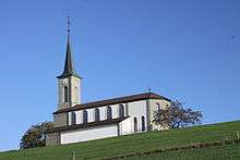 |
Saint-Maurice Church | Sus La Vellaz 84 | 564.406 | 172.265 | 46°42′02″N 6°58′24″E / 46.700645°N 6.973238°E |
Mézières
| KGS No.? |
Picture | Name | Street Address | CH1903 X coordinate | CH1903 Y coordinate | Location |
|---|---|---|---|---|---|---|
| 2228 | 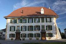 |
Mézières Castle | Route De L’Eglise 12 | 560.826 | 169.927 | 46°40′46″N 6°55′36″E / 46.679414°N 6.92663°E |
| 2229 |  |
Saint-Pierre-au-Liens Church | Route de l’Eglise 10 | 560.809 | 169.904 | 46°40′45″N 6°55′35″E / 46.679206°N 6.926409°E |
| Unknown | ISOS village: Mézières (FR) |
Montagny
| KGS No.? |
Picture | Name | Street Address | CH1903 X coordinate | CH1903 Y coordinate | Location |
|---|---|---|---|---|---|---|
| 2232 |  |
Notre-Dame Church | Montagny-Les-Monts, Route Du Pavement 24 | 565.922 | 184.488 | 46°48′38″N 6°59′32″E / 46.810674°N 6.992151°E |
| Unknown | ISOS cas particulier: Montagny-les-Monts |
Mont-Vully
| KGS No.? |
Picture | Name | Street Address | CH1903 X coordinate | CH1903 Y coordinate | Location |
|---|---|---|---|---|---|---|
| 2363 | 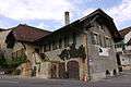 |
House De Steiger | Route Principale 136 | 574.068 | 200.279 | 46°57′11″N 7°05′53″E / 46.953085°N 7.097979°E |
| 2365 |  |
House d’Erlach-Velga | Rue du Château 1 | 573.997 | 200.236 | 46°57′10″N 7°05′49″E / 46.952695°N 7.097049°E |
| 2364 | 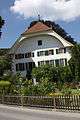 |
House de Wattenwyl | Rue du Château 18 | 573.916 | 200.281 | 46°57′11″N 7°05′46″E / 46.953097°N 7.095982°E |
| 2361 |  |
Mont Vully | 573.770 | 201.490 | 46°57′50″N 7°05′38″E / 46.963966°N 7.093995°E | |
| 9978 | House of W. J. Merz | Môtier, Route Du Lac 301 | 571.549 | 199.039 | 46°56′31″N 7°03′54″E / 46.941828°N 7.064966°E | |
| 2366 |  |
House Gatschet | Môtier, Route du Lac 95 | 573.169 | 199.816 | 46°56′56″N 7°05′10″E / 46.948884°N 7.086197°E |
| 2368 |  |
House Les Rondas | Guévaux, Route du Lac 361 | 571.049 | 198.686 | 46°56′19″N 7°03′30″E / 46.938631°N 7.058422°E |
| Unknown | ISOS village: Môtier | |||||
| Unknown | ISOS village: Praz |
Muntelier
| KGS No.? |
Picture | Name | Street Address | CH1903 X coordinate | CH1903 Y coordinate | Location |
|---|---|---|---|---|---|---|
| 2246 | 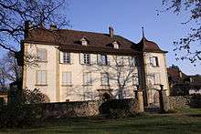 |
Von Ernst Manor house | Hauptstrasse 44 | 576.037 | 198.298 | 46°56′07″N 7°07′26″E / 46.935339°N 7.123949°E |
| 9599 | Platzbünden | Dorf, Fischergässli | 576.050 | 198.415 | 46°56′11″N 7°07′27″E / 46.936392°N 7.124114°E | |
| Unknown | ISOS Dorf: Muntelier |
Murist
| KGS No.? |
Picture | Name | Street Address | CH1903 X coordinate | CH1903 Y coordinate | Location |
|---|---|---|---|---|---|---|
| 9729 | 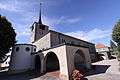 |
Saint-Pierre Church | Place De L’Eglise 1 | 551.803 | 182.333 | 46°47′26″N 6°48′27″E / 46.790418°N 6.807399°E |
| 2247 | 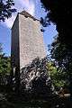 |
La Molière | ruines du château et du bourg | 552.920 | 183.160 | 46°47′53″N 6°49′19″E / 46.797936°N 6.821942°E |
Murten
| KGS No.? |
Picture | Name | Street Address | CH1903 X coordinate | CH1903 Y coordinate | Location |
|---|---|---|---|---|---|---|
| 9989 | 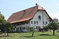 |
Farm House | Erli 2 | 579.508 | 200.782 | 46°57′28″N 7°10′10″E / 46.957799°N 7.169419°E |
| 2249 |  |
City Walls | 575.600 | 197.640 | 46°55′46″N 7°07′06″E / 46.929404°N 7.118246°E | |
| 9499 | 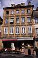 |
Grosshaus | Hauptgasse 43 | 575.552 | 197.576 | 46°55′44″N 7°07′03″E / 46.928827°N 7.117619°E |
| 2258 | 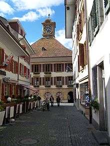 |
Rathaus (Town council house) | Rathausgasse 17 | 575.456 | 197.570 | 46°55′44″N 7°06′59″E / 46.928769°N 7.116359°E |
| 2256 |  |
Löwenberg Castle | Löwenberg 45 | 577.088 | 198.701 | 46°56′20″N 7°08′16″E / 46.939001°N 7.137731°E |
| 2307 | 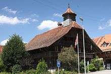 |
Old School Building | Hauptstrasse 81 | 577.994 | 195.779 | 46°54′46″N 7°08′59″E / 46.912748°N 7.14977°E |
| Unknown | ISOS Small City: Murten | |||||
| Unknown | ISOS Village: Salvenach | |||||
| Unknown | ISOS Village: Lurtigen |
Oberschrot
| KGS No.? |
Picture | Name | Street Address | CH1903 X coordinate | CH1903 Y coordinate | Location |
|---|---|---|---|---|---|---|
| Unknown | ISOS Dorf: Plaffeien (Oberschrot, Plaffeien) |
Pierrafortscha
| KGS No.? |
Picture | Name | Street Address | CH1903 X coordinate | CH1903 Y coordinate | Location |
|---|---|---|---|---|---|---|
| 2267 | 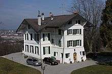 |
Chalet De Diesbach | Route De La Schürra 15 | 579.585 | 182.026 | 46°47′21″N 7°10′17″E / 46.789087°N 7.17127°E |
| 9991 | 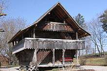 |
Grenier du Château d’En-Haut | Granges-sur-Marly, Route de Pierrafortscha 1A | 579.685 | 181.538 | 46°47′05″N 7°10′21″E / 46.7847°N 7.172601°E |
| Unknown | ISOS hameau: Granges-sur-Marly | |||||
| Unknown | ISOS hameau: Villars-sur-Marly |
Plaffeien
| KGS No.? |
Picture | Name | Street Address | CH1903 X coordinate | CH1903 Y coordinate | Location |
|---|---|---|---|---|---|---|
| 2269 |  |
Maria Geburt Parish Church | Im Dorf 1 | 588.317 | 176.806 | 46°44′32″N 7°17′09″E / 46.742341°N 7.285762°E |
| Unknown | ISOS Dorf: Plaffeien (Oberschrot, Plaffeien) |
Pont-en-Ogoz
| KGS No.? |
Picture | Name | Street Address | CH1903 X coordinate | CH1903 Y coordinate | Location |
|---|---|---|---|---|---|---|
| 1941 |  |
Farm House | Route De La Tour 35 | 572.513 | 170.932 | 46°41′21″N 7°04′46″E / 46.689038°N 7.079317°E |
| 10475 |  |
Ruines du château et du bourg de Pont-en-Ogoz | 574.110 | 171.960 | 46°41′54″N 7°06′00″E / 46.698349°N 7.100135°E |
Riaz
| KGS No.? |
Picture | Name | Street Address | CH1903 X coordinate | CH1903 Y coordinate | Location |
|---|---|---|---|---|---|---|
| 2286 | 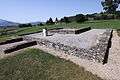 |
L’Etrey Gallo-Roman Villa |
570.780 | 166.080 | 46°38′43″N 7°03′25″E / 46.645318°N 7.056971°E | |
| 9993 | 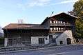 |
Paysanne House | Rue de la Roulema 10 | 571.156 | 165.438 | 46°38′22″N 7°03′43″E / 46.63956°N 7.061923°E |
Romont
| KGS No.? |
Picture | Name | Street Address | CH1903 X coordinate | CH1903 Y coordinate | Location |
|---|---|---|---|---|---|---|
| 2296 |  |
Cistercian Abbey De La Fille-Dieu | La Fille-Dieu 1 | 560.904 | 172.327 | 46°42′04″N 6°55′39″E / 46.701007°N 6.927445°E |
| 2293 | 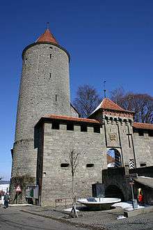 |
Romont Castle, Museum suisse du vitrail et Centre | 560.231 | 171.616 | 46°41′40″N 6°55′07″E / 46.694572°N 6.918707°E | |
| 2294 |  |
Notre-Dame de l’Assomption Collegiate church | Rue de l’Eglise 81 | 560.204 | 171.717 | 46°41′44″N 6°55′06″E / 46.695479°N 6.918345°E |
| 2295 | 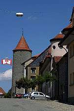 |
Fortifications | 560.200 | 171.700 | 46°41′43″N 6°55′06″E / 46.695325°N 6.918294°E | |
| Unknown | ISOS petite Village / bourg: Romont (FR) |
Rue
| KGS No.? |
Picture | Name | Street Address | CH1903 X coordinate | CH1903 Y coordinate | Location |
|---|---|---|---|---|---|---|
| 2304 |  |
Rue Castle | Le Château 1 | 552.802 | 163.379 | 46°37′12″N 6°49′21″E / 46.619994°N 6.822431°E |
| 9107 |  |
House of Maillardoz de Prez | Rue du Casino 35 | 552.851 | 163.365 | 46°37′12″N 6°49′23″E / 46.619871°N 6.823072°E |
| Unknown | ISOS petite Village / bourg: Rue | |||||
| Unknown | ISOS village: Promasens |
Sâles
| KGS No.? |
Picture | Name | Street Address | CH1903 X coordinate | CH1903 Y coordinate | Location |
|---|---|---|---|---|---|---|
| Unknown | ISOS hameau: Rueyres-Treyfayes |
Schmitten
| KGS No.? |
Picture | Name | Street Address | CH1903 X coordinate | CH1903 Y coordinate | Location |
|---|---|---|---|---|---|---|
| 2309 | 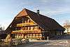 |
Farm House of the Wirt, Wilhelm Vonlanthen | Bahnhofstrasse 1 | 585.481 | 189.449 | 46°51′22″N 7°14′54″E / 46.856014°N 7.248251°E |
| 2311 | 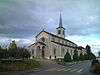 |
Kreuzauffindung Parish Church | Gwattstrasse 1 | 585.550 | 189.473 | 46°51′22″N 7°14′57″E / 46.856231°N 7.249155°E |
Sévaz
| KGS No.? |
Picture | Name | Street Address | CH1903 X coordinate | CH1903 Y coordinate | Location |
|---|---|---|---|---|---|---|
| 9600 | Tudinges, Iron Age, Metal Workshop |
556.900 | 186.900 | 46°49′55″N 6°52′25″E / 46.831848°N 6.873721°E |
Siviriez
| KGS No.? |
Picture | Name | Street Address | CH1903 X coordinate | CH1903 Y coordinate | Location |
|---|---|---|---|---|---|---|
| Unknown | ISOS village: Chavannes-les-Forts |
St. Ursen
| KGS No.? |
Picture | Name | Street Address | CH1903 X coordinate | CH1903 Y coordinate | Location |
|---|---|---|---|---|---|---|
| 2319 |  |
Farm House of Joseph von der Weid | Römerswil 5 | 580.982 | 182.716 | 46°47′43″N 7°11′22″E / 46.795335°N 7.189537°E |
| 2317 |  |
Ofenhaus | Geretach 2 B | 587.118 | 180.956 | 46°46′47″N 7°16′12″E / 46.77965°N 7.269956°E |
Surpierre
| KGS No.? |
Picture | Name | Street Address | CH1903 X coordinate | CH1903 Y coordinate | Location |
|---|---|---|---|---|---|---|
| 2322 |  |
Baillival Castle | Le Château 1 | 556.072 | 177.259 | 46°44′42″N 6°51′50″E / 46.745071°N 6.863795°E |
Tafers
| KGS No.? |
Picture | Name | Street Address | CH1903 X coordinate | CH1903 Y coordinate | Location |
|---|---|---|---|---|---|---|
| 2323 |  |
Parish Church of St. Martin | Kirchweg 3 | 583.140 | 184.880 | 46°48′53″N 7°13′04″E / 46.814859°N 7.217723°E |
| 9997 | 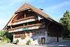 |
Sigristen House | Kirchweg 2 | 583.085 | 184.897 | 46°48′54″N 7°13′01″E / 46.81501°N 7.217002°E |
Torny
| KGS No.? |
Picture | Name | Street Address | CH1903 X coordinate | CH1903 Y coordinate | Location |
|---|---|---|---|---|---|---|
| 2328 | 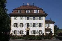 |
De Diesbach Castle | Torny-Le-Grand, Au Château 4 | 563.881 | 180.222 | 46°46′20″N 6°57′57″E / 46.772193°N 6.965747°E |
| 2230 |  |
Griset de Forel Castle with park |
Middes, A Middes 21 | 562.414 | 179.817 | 46°46′06″N 6°56′48″E / 46.768469°N 6.946574°E |
| Unknown | ISOS hameau: Torny-le-Petit |
Treyvaux
| KGS No.? |
Picture | Name | Street Address | CH1903 X coordinate | CH1903 Y coordinate | Location |
|---|---|---|---|---|---|---|
| 2333 | 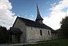 |
Former Church of Saint-Pierre | Chemin De Vers-Saint-Pierre 72 A | 575.316 | 176.170 | 46°44′11″N 7°06′56″E / 46.736265°N 7.115677°E |
| 9998 | 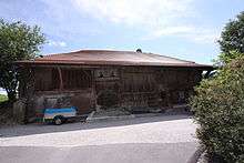 |
Farm House | Le Pré de la Maison 12 | 577.053 | 175.196 | 46°43′39″N 7°08′18″E / 46.727566°N 7.138452°E |
Ursy
| KGS No.? |
Picture | Name | Street Address | CH1903 X coordinate | CH1903 Y coordinate | Location |
|---|---|---|---|---|---|---|
| 9999 | 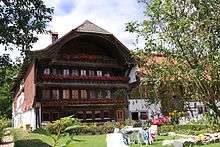 |
D’Invau, Farm House | Mossel, Route D’Invau 51 | 556.284 | 162.832 | 46°36′55″N 6°52′05″E / 46.61531°N 6.867942°E |
Val-de-Charmey
| KGS No.? |
Picture | Name | Street Address | CH1903 X coordinate | CH1903 Y coordinate | Location |
|---|---|---|---|---|---|---|
| 1973 |  |
Chartreuse De La Valsainte | La Valsainte 196–199 | 580.889 | 166.487 | 46°38′58″N 7°11′20″E / 46.649345°N 7.188995°E |
| 1981 |  |
Alpine Chalet | Le Lapé 320 | 583.890 | 157.060 | 46°33′53″N 7°13′43″E / 46.564623°N 7.228526°E |
| 1980 |  |
Alpine Chalet | Pra de La Monse 249 | 578.400 | 162.091 | 46°36′35″N 7°09′24″E / 46.609725°N 7.156689°E |
| Unknown | ISOS cas particulier: La Valsainte |
Vallon
| KGS No.? |
Picture | Name | Street Address | CH1903 X coordinate | CH1903 Y coordinate | Location |
|---|---|---|---|---|---|---|
| 2338 |  |
Saint-Pierre Church | Carignan 3 | 563.146 | 191.789 | 46°52′34″N 6°57′19″E / 46.8762°N 6.955191°E |
| 2339 | |
Sur Dompierre Gallo-Roman Villa |
563.280 | 191.820 | 46°52′35″N 6°57′25″E / 46.876486°N 6.956947°E |
Villarsel-sur-Marly
| KGS No.? |
Picture | Name | Street Address | CH1903 X coordinate | CH1903 Y coordinate | Location |
|---|---|---|---|---|---|---|
| 10001 |  |
Farm House of the Commandry of Saint-Jean | Chemin De Villarsel 83 | 579.819 | 178.793 | 46°45′36″N 7°10′28″E / 46.760012°N 7.174477°E |
| Unknown | ISOS hameau: Villarsel-sur-Marly |
Villars-sur-Glâne
| KGS No.? |
Picture | Name | Street Address | CH1903 X coordinate | CH1903 Y coordinate | Location |
|---|---|---|---|---|---|---|
| 10002 |  |
Farm House De La Campagne De Chollet Au Guintzet | Avenue Jean-Paul Ii 16 | 577.233 | 183.813 | 46°48′18″N 7°08′25″E / 46.805085°N 7.140378°E |
| 2346 |  |
Pont de la Glâne (Shared with Hauterive) | Route de la Glâne | 576.147 | 181.576 | 46°47′06″N 7°07′35″E / 46.784924°N 7.126268°E |
| 10500 |  |
Pont et Chapel de Sainte-Apolline (Shared with Hauterive) | Chemin des Auges | 575.401 | 181.510 | 46°47′03″N 7°06′59″E / 46.784304°N 7.116502°E |
Villarvolard
| KGS No.? |
Picture | Name | Street Address | CH1903 X coordinate | CH1903 Y coordinate | Location |
|---|---|---|---|---|---|---|
| 10004 |  |
Repond House | Au Village 169 | 574.603 | 166.119 | 46°38′45″N 7°06′25″E / 46.645825°N 7.106904°E |
| Unknown | ISOS village: Villarvolard |
Villorsonnens
| KGS No.? |
Picture | Name | Street Address | CH1903 X coordinate | CH1903 Y coordinate | Location |
|---|---|---|---|---|---|---|
| 10006 |  |
Church of Saint-Pierre | Orsonnens, Au Village 78 | 565.990 | 174.124 | 46°43′03″N 6°59′38″E / 46.71745°N 6.993811°E |
| Unknown | ISOS village: Orsonnens |
Vuissens
| KGS No.? |
Picture | Name | Street Address | CH1903 X coordinate | CH1903 Y coordinate | Location |
|---|---|---|---|---|---|---|
| Unknown | ISOS village: Vuissens |
Vuisternens-devant-Romont
| KGS No.? |
Picture | Name | Street Address | CH1903 X coordinate | CH1903 Y coordinate | Location |
|---|---|---|---|---|---|---|
| 10009 | 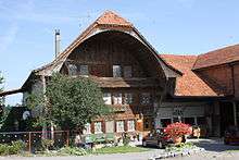 |
Farm House | Route De Villariaz 11 | 561.203 | 167.438 | 46°39′25″N 6°55′54″E / 46.657046°N 6.931767°E |
Wünnewil-Flamatt
| KGS No.? |
Picture | Name | Street Address | CH1903 X coordinate | CH1903 Y coordinate | Location |
|---|---|---|---|---|---|---|
| 2374 |  |
De Weck Country Mansion | Bluemisberg 3 | 588.500 | 191.260 | 46°52′21″N 7°17′16″E / 46.872363°N 7.287793°E |
| 2376 | .jpg) |
Chapel of St. Beatus | Sensebrück 21 | 589.399 | 193.463 | 46°53′32″N 7°17′58″E / 46.892195°N 7.299534°E |
| 10010 |  |
Apartment Buildings Flamatt 1 and 2 | Neueneggstrasse 6–10 | 590.163 | 193.271 | 46°53′26″N 7°18′34″E / 46.890479°N 7.309563°E |
| 9515 | .jpg) |
Toll Station | Sensebrück 14 | 589.416 | 193.491 | 46°53′33″N 7°17′59″E / 46.892447°N 7.299757°E |
References
- All entries, addresses and coordinates are from: "Kantonsliste A-Objekte". KGS Inventar (in German). Federal Office of Civil Protection. 2009. Retrieved 25 April 2011.
External links
- Swiss Inventory of Cultural Property of National and Regional Significance, 2009 edition:
- "Revision of the PCP Inventory (Revision des KGS-Inventars)". KGS Forum. Federal Office of Civil Protection (13/2008). 2008.
This article is issued from Wikipedia - version of the 8/12/2016. The text is available under the Creative Commons Attribution/Share Alike but additional terms may apply for the media files.