List of cultural property of national significance in Switzerland: Schwyz
This list contains all cultural property of national significance (class A) in the canton of Schwyz from the 2009 Swiss Inventory of Cultural Property of National and Regional Significance. It is sorted by municipality and contains 49 individual buildings, 8 collections, 10 archaeological finds and 1 other, special site or object.
The geographic coordinates provided are in the Swiss coordinate system as given in the Inventory.
Altendorf
| KGS No.? |
Picture | Name | Street Address | CH1903 X coordinate | CH1903 Y coordinate | Location |
|---|---|---|---|---|---|---|
| 10482 | Alt Rapperswil, Castle Site |
706.300 | 226.950 | 47°11′06″N 8°50′28″E / 47.184953°N 8.841181°E | ||
| 4763 | 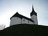 |
St. Johann Chapel and Sigristen House | Burgweg 28 | 706.300 | 226.950 | 47°11′06″N 8°50′28″E / 47.184953°N 8.841181°E |
| Unknown | ISOS Weiler: Seestatt |
Arth
| KGS No.? |
Picture | Name | Street Address | CH1903 X coordinate | CH1903 Y coordinate | Location |
|---|---|---|---|---|---|---|
| 11625 | 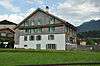 |
Alte Post Haus | Gotthardstrasse 29 | 683.280 | 212.238 | 47°03′21″N 8°32′05″E / 47.055932°N 8.534784°E |
| 10175 |  |
High Platform of the Rigibahn | Bahnhofstrasse | 684.278 | 211.499 | 47°02′57″N 8°32′52″E / 47.049159°N 8.54778°E |
| 11626 |  |
Reding Chapel | Gotthardstrasse 25 | 683.224 | 212.313 | 47°03′24″N 8°32′03″E / 47.056614°N 8.53406°E |
| 9673 |  |
Medieval Letzinen | 683.260 | 212.280 | 47°03′23″N 8°32′04″E / 47.056312°N 8.534528°E | |
| 4766 |  |
Parish Church of St. Georg and Zeno | 682.380 | 213.080 | 47°03′49″N 8°31′23″E / 47.063618°N 8.523092°E | |
| Unknown | ISOS Dorf: Arth |
Einsiedeln
| KGS No.? |
Picture | Name | Street Address | CH1903 X coordinate | CH1903 Y coordinate | Location |
|---|---|---|---|---|---|---|
| 9309 |  |
Library of the Werner Oechslin Foundation | Luegetenstrasse 11 | 699.321 | 220.179 | 47°07′31″N 8°44′51″E / 47.125142°N 8.747626°E |
| 4774, 8913, 8520 | 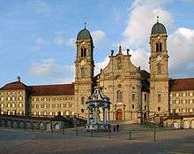 |
Einsiedeln Abbey | 699.700 | 220.370 | 47°07′36″N 8°45′10″E / 47.126803°N 8.752663°E | |
| 9400 |  |
Zur Ilge House | Schwanenstrasse 44 | 699.488 | 220.303 | 47°07′34″N 8°44′59″E / 47.126232°N 8.749854°E |
| 4778 |  |
Meinrads Chapel and St. Meinrad Pilgrims' House | 701.101 | 225.55 | 47°10′23″N 8°46′20″E / 47.173177°N 8.772284°E | |
| 4777 |  |
Teufelsbrücke am Etzel | 700.730 | 224.900 | 47°10′03″N 8°46′02″E / 47.167388°N 8.767246°E | |
| Unknown | ISOS Kleinstadt / Flecken: Einsiedeln | |||||
| Unknown | ISOS ISOS Spezialfall: Etzelpass, St. Meinrad |
Freienbach
| KGS No.? |
Picture | Name | Street Address | CH1903 X coordinate | CH1903 Y coordinate | Location |
|---|---|---|---|---|---|---|
| 9669 |  |
Hurden / Seedamm, Prehistoric & Historic Bridge |
703.750 | 230.680 | 47°13′08″N 8°48′30″E / 47.218903°N 8.808402°E | |
| 4787 |  |
Parish church of St. Peter and Paul and Martinskapelle | Ufnau | 701.500 | 230.540 | 47°13′05″N 8°46′43″E / 47.217993°N 8.77867°E |
| 8514 | Seedamm Cultural Center - Pfäffikon | Gwattstrasse 15 / Talstrasse | 702.710 | 228.641 | 47°12′03″N 8°47′39″E / 47.200728°N 8.794209°E | |
| 4788 | 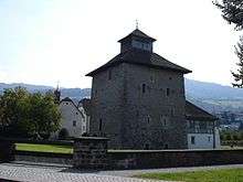 |
Stiftsstatthalterei with Castle Tower and moat | Unterdorfstrasse | 701.236 | 229.051 | 47°12′17″N 8°46′29″E / 47.204642°N 8.774851°E |
| 9670 |  |
Ufnau, Prehistoric Lake Shore Settlement / Roman era temple / Medieval settlement |
701.500 | 230.540 | 47°13′05″N 8°46′43″E / 47.217993°N 8.77867°E | |
| Unknown | ISOS Spezialfall: Pfäffikon Unterdorf | |||||
| Unknown | ISOS Spezialfall: Insel Ufnau |
Galgenen
| KGS No.? |
Picture | Name | Street Address | CH1903 X coordinate | CH1903 Y coordinate | Location |
|---|---|---|---|---|---|---|
| 4795 | St. Jost Chapel | 708.791 | 226.265 | 47°10′42″N 8°52′26″E / 47.178387°N 8.873876°E | ||
| 4794 | 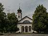 |
Catholic Parish Church of St. Martin | 708.820 | 226.700 | 47°10′56″N 8°52′28″E / 47.182294°N 8.874363°E | |
| Unknown | ISOS Verstädtertes Dorf: Siebnen Galgenen |
Gersau
| KGS No.? |
Picture | Name | Street Address | CH1903 X coordinate | CH1903 Y coordinate | Location |
|---|---|---|---|---|---|---|
| 4799 | 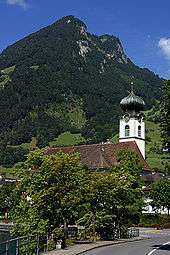 |
Parish Church of St. Marzellus | Grandstrasse | 682.960 | 205.040 | 46°59′28″N 8°31′45″E / 46.991232°N 8.529256°E |
| Unknown | ISOS Dorf: Gersau |
Ingenbohl
| KGS No.? |
Picture | Name | Street Address | CH1903 X coordinate | CH1903 Y coordinate | Location |
|---|---|---|---|---|---|---|
| Unknown | ISOS Verstädtertes Dorf: Brunnen |
Küssnacht
| KGS No.? |
Picture | Name | Street Address | CH1903 X coordinate | CH1903 Y coordinate | Location |
|---|---|---|---|---|---|---|
| 4813 | 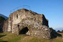 |
Ruins of the Gesslerburg Castle | Seebodenstrasse | 676.700 | 215.050 | 47°04′55″N 8°26′55″E / 47.082018°N 8.448663°E |
| 4815 | 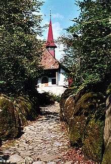 |
Hohle Gasse with Tell Chapel | Hohle Gasse | 677.027 | 216.231 | 47°05′33″N 8°27′11″E / 47.092602°N 8.453169°E |
| Unknown | ISOS Kleinstadt / Flecken: Küssnacht am Rigi | |||||
| Unknown | ISOS Weiler: Merlischachen |
Lachen
| KGS No.? |
Picture | Name | Street Address | CH1903 X coordinate | CH1903 Y coordinate | Location |
|---|---|---|---|---|---|---|
| 4823 | 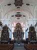 |
Catholic Parish Church of Heilig-Kreuz | Kirchplatz | 707.020 | 227.790 | 47°11′33″N 8°51′03″E / 47.192391°N 8.850879°E |
| Unknown | ISOS Kleinstadt / Flecken: Lachen |
Morschach
| KGS No.? |
Picture | Name | Street Address | CH1903 X coordinate | CH1903 Y coordinate | Location |
|---|---|---|---|---|---|---|
| 11627 |  |
Silbergasse House | 690.063 | 204.213 | 46°58′58″N 8°37′21″E / 46.982868°N 8.622457°E | |
| 11628 |  |
Tannen House | 689.871 | 201.875 | 46°57′43″N 8°37′10″E / 46.961866°N 8.619471°E | |
| 11629 | _renoviert.JPG) |
Tannen (Sträbismattli) House | 689.944 | 201.854 | 46°57′42″N 8°37′14″E / 46.961667°N 8.620426°E |
Muotathal
| KGS No.? |
Picture | Name | Street Address | CH1903 X coordinate | CH1903 Y coordinate | Location |
|---|---|---|---|---|---|---|
| 4833 | 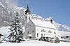 |
Catholic Parish Church of St. Sigismund and Walpurga | Wil | 700.540 | 203.770 | 46°58′39″N 8°45′36″E / 46.97738°N 8.760048°E |
| Unknown | ISOS Dorf: Muotathal |
Rothenthurm
| KGS No.? |
Picture | Name | Street Address | CH1903 X coordinate | CH1903 Y coordinate | Location |
|---|---|---|---|---|---|---|
| 9672 | Medieval Letzinen, A Watchtower | 693.460 | 217.800 | 47°06′17″N 8°40′12″E / 47.104599°N 8.669903°E | ||
| 11652 |  |
Roter Turm und Tor (Red Tower and Gate) |
693.932 | 217.970 | 47°06′22″N 8°40′34″E / 47.106061°N 8.676155°E | |
| Unknown | ISOS Weiler: Biberegg |
Sattel
| KGS No.? |
Picture | Name | Street Address | CH1903 X coordinate | CH1903 Y coordinate | Location |
|---|---|---|---|---|---|---|
| 10210, 9674 |  |
Letziturm and Medieval Letzinen (Fortifications) |
690.800 | 216.290 | 47°05′29″N 8°38′04″E / 47.091388°N 8.634562°E | |
| 4842 | 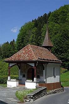 |
Battle of Morgarten Memorial and Chapel | Ägeristrasse | 690.727 | 216.151 | 47°05′25″N 8°38′01″E / 47.090148°N 8.633572°E |
| Unknown | ISOS Weiler: Ecce Homo |
Schübelbach
| KGS No.? |
Picture | Name | Street Address | CH1903 X coordinate | CH1903 Y coordinate | Location |
|---|---|---|---|---|---|---|
| 4848 | Siebnen Powerplant | Kraftwerk Wägital | 710.790 | 225.550 | 47°10′18″N 8°54′00″E / 47.171625°N 8.900066°E | |
| Unknown | ISOS Verstädtertes Dorf: Siebnen (Galgenen |
Schwyz
| KGS No.? |
Picture | Name | Street Address | CH1903 X coordinate | CH1903 Y coordinate | Location |
|---|---|---|---|---|---|---|
| 4850 |  |
Bundesbriefmuseum (Federal Charter Museum) |
Bahnhofstrasse 20 | 691.965 | 208.613 | 47°01′20″N 8°38′54″E / 47.022181°N 8.648345°E |
| 4858 | 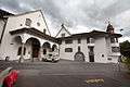 |
Dominican Nuns Convent of St. Peter am Bach | Strehlgasse 18 | 692.584 | 208.374 | 47°01′12″N 8°39′23″E / 47.019945°N 8.656437°E |
| 9675 |  |
Village, Medieval / Early Modern Settlement |
692.500 | 208.450 | 47°01′14″N 8°39′19″E / 47.020641°N 8.655348°E | |
| 11689 | 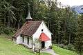 |
Hermitage with Chapel, 14 Emergency Helpers and a Brothers' House |
Bergstrasse, Tschütschi, Rickenbach | 693.750 | 208.380 | 47°01′11″N 8°40′18″E / 47.019836°N 8.671773°E |
| 11789 | 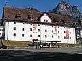 |
Forum der Schweizer Geschichte (Forum of Swiss History) |
Hofmatt, Zeughausstrasse 5 | 692.213 | 208.521 | 47°01′17″N 8°39′06″E / 47.021319°N 8.651588°E |
| 4861 | 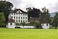 |
Ab Yberg im Grund House with St. Sebastian Chapel | Grundstrasse 82 | 692.674 | 207.559 | 47°00′45″N 8°39′27″E / 47.012603°N 8.657454°E |
| 9750 | 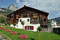 |
Bethlehem House | Reichsstrasse 9 | 692.474 | 208.504 | 47°01′16″N 8°39′18″E / 47.02113°N 8.655017°E |
| 4862 | 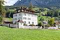 |
Ceberg im Feldli House | Theodosiusweg 20 | 692.500 | 208.880 | 47°01′28″N 8°39′20″E / 47.024508°N 8.655436°E |
| 11630 | 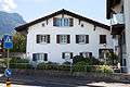 |
House | Gotthardstrasse 99, Ibach | 691.705 | 207.744 | 47°00′52″N 8°38′41″E / 47.014401°N 8.64475°E |
| 4860 | 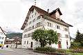 |
Grosshus House | Strehlgasse 12 | 692.488 | 208.383 | 47°01′12″N 8°39′19″E / 47.02004°N 8.655176°E |
| 11631 |  |
Immenfeld House | 692.995 | 207.620 | 47°00′47″N 8°39′42″E / 47.013106°N 8.661688°E | |
| 11632 | 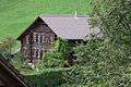 |
House | Langfeldweg 14, Kaltbach | 691.634 | 209.895 | 47°02′02″N 8°38′39″E / 47.033757°N 8.644251°E |
| 11633 | 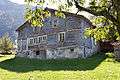 |
House | Oberschönenbuch 79, Ibach | 691.911 | 205.844 | 46°59′50″N 8°38′49″E / 46.997284°N 8.647074°E |
| 4879 |  |
Herrenhaus Waldegg | Waldeggstrasse | 693.030 | 207.839 | 47°00′54″N 8°39′44″E / 47.015071°N 8.662193°E |
| 4866 | 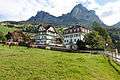 |
Hettlingerhäuser | Rickenbachstrasse 31, 35 | 692.625 | 208.615 | 47°01′20″N 8°39′25″E / 47.022107°N 8.657026°E |
| 4852 | 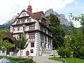 |
Hofstatt Ital Reding | Rickenbachstrasse 24 | 692.539 | 208.564 | 47°01′18″N 8°39′21″E / 47.02166°N 8.655884°E |
| 9749, 4853 | 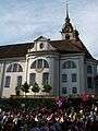 |
Catholic Parish Church of St. Martin with Kerchel and Heiligkreuz Chapel |
Hauptplatz / Schulgasse | 692.360 | 208.518 | 47°01′17″N 8°39′13″E / 47.021272°N 8.653521°E |
| 4873 |  |
Maihof | Palais Nideröst, Schlagstrasse | 691.751 | 209.265 | 47°01′41″N 8°38′44″E / 47.028075°N 8.645662°E |
| 4854 | 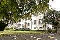 |
Palais Büeler (formerly Palais von Weber) | Herrengasse 42 | 691.992 | 208.748 | 47°01′24″N 8°38′55″E / 47.023391°N 8.648727°E |
| 4855 | 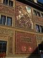 |
Rathaus (Town council house) | Hauptplatz 1 | 692.387 | 208.458 | 47°01′15″N 8°39′14″E / 47.020728°N 8.653863°E |
| 4876 |  |
Reding House | Schmiedgasse 6 | 692.256 | 208.422 | 47°01′14″N 8°39′08″E / 47.020423°N 8.652133°E |
| 8802 |  |
State Archives of Schwyz | Kollegiumstrasse 30 | 692.423 | 208.873 | 47°01′28″N 8°39′16″E / 47.024456°N 8.654421°E |
| 9757 | 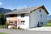 |
House (Köplihaus) | Engiberg 4, 8 | 690.555 | 210.280 | 47°02′15″N 8°37′48″E / 47.037368°N 8.630133°E |
| Unknown | ISOS Kleinstadt / Flecken: Schwyz |
Steinen
| KGS No.? |
Picture | Name | Street Address | CH1903 X coordinate | CH1903 Y coordinate | Location |
|---|---|---|---|---|---|---|
| 4884 |  |
Beinhaus | Dorfplatz | 689.265 | 211.680 | 47°03′00″N 8°36′48″E / 47.050135°N 8.613438°E |
| 11765 |  |
Former Cistercian Nuns Convent in of the Au | 688.650 | 210.570 | 47°02′25″N 8°36′18″E / 47.040234°N 8.605128°E | |
| 11766 |  |
House | Herrengasse 11 | 689.161 | 211.572 | 47°02′57″N 8°36′43″E / 47.049177°N 8.612048°E |
| 11767 |  |
House | Herrengasse 15 | 689.150 | 211.579 | 47°02′57″N 8°36′43″E / 47.049242°N 8.611905°E |
| 11768 | 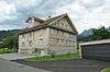 |
House | Räbengasse 17 (Feld) | 689.172 | 211.139 | 47°02′43″N 8°36′44″E / 47.045281°N 8.612108°E |
| Unknown | ISOS Dorf: Steinen |
Tuggen
| KGS No.? |
Picture | Name | Street Address | CH1903 X coordinate | CH1903 Y coordinate | Location |
|---|---|---|---|---|---|---|
| Unknown | Grinau Tower | 716.005 | 230.634 | 47°12′59″N 8°58′13″E / 47.216452°N 8.970149°E | ||
| Unknown | ISOS Spezialfall: Grinau |
Wangen
| KGS No.? |
Picture | Name | Street Address | CH1903 X coordinate | CH1903 Y coordinate | Location |
|---|---|---|---|---|---|---|
| Unknown | ISOS Verstädtertes Dorf: Siebnen (Galgenen |
References
- All entries, addresses and coordinates are from: "Kantonsliste A-Objekte". KGS Inventar (in German). Federal Office of Civil Protection. 2009. Retrieved 25 April 2011.
External links
- Swiss Inventory of Cultural Property of National and Regional Significance, 2009 edition:
- "Revision of the PCP Inventory (Revision des KGS-Inventars)". KGS Forum. Federal Office of Civil Protection (13/2008). 2008.
This article is issued from Wikipedia - version of the 8/12/2016. The text is available under the Creative Commons Attribution/Share Alike but additional terms may apply for the media files.