List of cultural property of national significance in Switzerland: Zug
This list contains all cultural property of national significance (class A) in the canton of Zug from the 2009 Swiss Inventory of Cultural Property of National and Regional Significance. It is sorted by municipality and contains 16 individual buildings, 10 collections and 5 archaeological finds.
The geographic coordinates provided are in the Swiss coordinate system as given in the Inventory.
Baar
| KGS No.? |
Picture | Name | Street Address | CH1903 X coordinate | CH1903 Y coordinate | Location |
|---|---|---|---|---|---|---|
| 7232 | 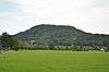 |
Baarburg Prehistoric-Medieval Hilltop Settlement |
684.500 | 228.800 | 47°12′17″N 8°33′14″E / 47.204736°N 8.553937°E | |
| 10369 | 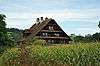 |
House (Versicherungs-Number 196 a) |
Sennweid | 682.522 | 228.344 | 47°12′03″N 8°31′40″E / 47.200885°N 8.52775°E |
| Unknown | ISOS Spezialfall: Spinnerei an of the Lorze |
Cham
| KGS No.? |
Picture | Name | Street Address | CH1903 X coordinate | CH1903 Y coordinate | Location |
|---|---|---|---|---|---|---|
| 7253 |  |
Catholic Church of St. Jakob | Kirchbühl | 677.380 | 225.880 | 47°10′46″N 8°27′34″E / 47.179345°N 8.459471°E |
| 7244 |  |
Church and Monastery of the Cistercian Nuns | Frauenthal | 674.638 | 229.627 | 47°12′48″N 8°25′26″E / 47.213361°N 8.423922°E |
| 7257 | 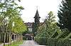 |
St. Andreas Castle | St. Andreas 1 | 677.895 | 225.830 | 47°10′44″N 8°27′59″E / 47.178835°N 8.466256°E |
| 10370 | 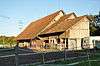 |
Barn (Versicherungs-Number 110 b) | Fildernweg 3 | 676.350 | 227.175 | 47°11′28″N 8°26′46″E / 47.191112°N 8.446104°E |
| 10371 | 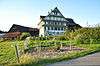 |
House (Versicherungs-Number 49 a) | Bibersee 2 | 678.205 | 228.769 | 47°12′19″N 8°28′15″E / 47.205232°N 8.470855°E |
| 7245 | 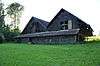 |
Ziegelhütte | Meienberg | 674.770 | 227.665 | 47°11′45″N 8°25′31″E / 47.1957°N 8.425338°E |
| Unknown | ISOS Verstädtertes Dorf: Cham | |||||
| Unknown | ISOS Dorf: Niederwil | |||||
| Unknown | ISOS Spezialfall: Fabrikanlage Lorzenweid | |||||
| Unknown | ISOS Spezialfall: Monastery Frauental |
Hünenberg
| KGS No.? |
Picture | Name | Street Address | CH1903 X coordinate | CH1903 Y coordinate | Location |
|---|---|---|---|---|---|---|
| 7262 | 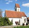 |
Catholic Church of St. Wolfgang | 674.980 | 226.699 | 47°11′13″N 8°25′41″E / 47.186988°N 8.427949°E | |
| Unknown | ISOS Weiler: Meisterswil/Talacher | |||||
| Unknown | ISOS Spezialfall: St.Wolfgang/Wart |
Menzingen
| KGS No.? |
Picture | Name | Street Address | CH1903 X coordinate | CH1903 Y coordinate | Location |
|---|---|---|---|---|---|---|
| Unknown | ISOS Spezialfall: Hofsiedlung Brettigen / Schwand | |||||
| Unknown | ISOS Spezialfall: Kloster Gubel |
Neuheim
| KGS No.? |
Picture | Name | Street Address | CH1903 X coordinate | CH1903 Y coordinate | Location |
|---|---|---|---|---|---|---|
| Unknown | ISOS Spezialfall: Hofsiedlung Brettigen / Schwand |
Risch-Rotkreuz
| KGS No.? |
Picture | Name | Street Address | CH1903 X coordinate | CH1903 Y coordinate | Location |
|---|---|---|---|---|---|---|
| Unknown | ISOS Weiler: Berchtwil | |||||
| Unknown | ISOS Spezialfall: Ufersiedlungslandschaft Risch / Buonas |
Unterägeri
| KGS No.? |
Picture | Name | Street Address | CH1903 X coordinate | CH1903 Y coordinate | Location |
|---|---|---|---|---|---|---|
| Unknown | ISOS Spezialfall: Innere Spinnerei |
Zug
| KGS No.? |
Picture | Name | Street Address | CH1903 X coordinate | CH1903 Y coordinate | Location |
|---|---|---|---|---|---|---|
| 8954, 10551, 8595 | Archive of the Amtes Für Denkmalpflege und Archäologie, Archive of Bauernhausforschung and Early History Museum |
Hofstrasse 15 | 681.672 | 223.796 | 47°09′36″N 8°30′57″E / 47.160086°N 8.515709°E | |
| 9350 | 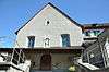 |
Library of the former Capuchin Monastery of Zug |
Kapuzinergässli 1 | 681.769 | 224.526 | 47°10′00″N 8°31′02″E / 47.166639°N 8.517121°E |
| 8891 | 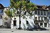 |
Citizens' Archive of Zug | Rathaus / Ober Altstadt 18 a | 681.614 | 224.406 | 47°09′56″N 8°30′54″E / 47.165579°N 8.515055°E |
| 7325, 8560 |  |
Zug Castle and Museum in the Castle | Kirchenstrasse 11 | 681.744 | 224.351 | 47°09′54″N 8°31′00″E / 47.165069°N 8.516759°E |
| 7326 |  |
Catholic Church of St. Oswald with Ossuary | St. Oswalds-Gasse | 681.685 | 224.367 | 47°09′55″N 8°30′58″E / 47.16522°N 8.515984°E |
| 8558 | 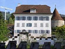 |
Art Museum | Dorfstrasse 27 | 681.790 | 224.336 | 47°09′54″N 8°31′03″E / 47.164928°N 8.517363°E |
| 9518 |  |
Lehrerseminar St. Michael | Zugerbergstrasse 3 a | 681.881 | 224.022 | 47°09′44″N 8°31′07″E / 47.162093°N 8.518506°E |
| 9317 | 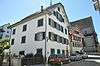 |
Parish Library of St. Michael | St. Oswalds-Gasse 5 | 681.698 | 224.404 | 47°09′56″N 8°30′58″E / 47.165551°N 8.516162°E |
| 11704 | _1.jpg) |
Riedmatt, Neolithic Lake Shore Settlement |
679.700 | 225.700 | 47°10′39″N 8°29′24″E / 47.177451°N 8.490042°E | |
| 8796 |  |
State Archives of Zug | Aabachstrasse 5 | 681.268 | 225.381 | 47°10′28″N 8°30′38″E / 47.174391°N 8.510668°E |
| 10414 | 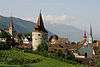 |
City Walls | 681.653 | 224.460 | 47°09′58″N 8°30′56″E / 47.16606°N 8.515579°E | |
| 10372 |  |
Rüschenhof Barn (Versicherungs-Number 424 e) | 682.611 | 225.181 | 47°10′21″N 8°31′42″E / 47.172426°N 8.528345°E | |
| 10413 | 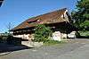 |
Barn (Versicherungs-Number 424 d) | 682.500 | 225.225 | 47°10′22″N 8°31′37″E / 47.172835°N 8.526889°E | |
| 7328 | _3.jpg) |
Sumpf, Late-Bronze Age Lake Shore Settlement |
678.800 | 226.300 | 47°10′59″N 8°28′42″E / 47.182955°N 8.478276°E | |
| 8811 |  |
Corporate Archives of Landis+Gyr AG | Gubelstrasse 22 | 681.522 | 225.525 | 47°10′32″N 8°30′51″E / 47.175655°N 8.514044°E |
| 10373 | 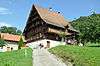 |
House (Versicherungs-Number 354 a) | Otterswil | 680.604 | 220.346 | 47°07′45″N 8°30′04″E / 47.129187°N 8.501011°E |
| 7330 | 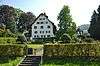 |
Zurlaubenhof | Hofstrasse 5 | 681.747 | 224.011 | 47°09′43″N 8°31′00″E / 47.16201°N 8.516737°E |
| Unknown | ISOS Stadt: Zug | |||||
| Unknown | ISOS Spezialfall: Schönfels / Felsenegg |
References
- All entries, addresses and coordinates are from: "Kantonsliste A-Objekte". KGS Inventar (in German). Federal Office of Civil Protection. 2009. Retrieved 25 April 2011.
External links
- Swiss Inventory of Cultural Property of National and Regional Significance, 2009 edition:
- "Revision of the PCP Inventory (Revision des KGS-Inventars)". KGS Forum. Federal Office of Civil Protection (13/2008). 2008.
This article is issued from Wikipedia - version of the 8/12/2016. The text is available under the Creative Commons Attribution/Share Alike but additional terms may apply for the media files.