Lock and Dam No. 4
 Mississippi River Lock and Dam No. 4 | |
| Location | Greenfield Township, Wabasha County, Minnesota / Alma, Wisconsin, USA |
|---|---|
| Coordinates | 44°19′32″N 91°55′13″W / 44.32556°N 91.92028°WCoordinates: 44°19′32″N 91°55′13″W / 44.32556°N 91.92028°W |
| Construction began | 1932 |
| Opening date | May 1935 |
| Operator(s) | United States Army Corps of Engineers |
| Dam and spillways | |
| Impounds | Upper Mississippi River |
| Length | 1,367 feet (416.7 m) (movable portion) |
| Reservoir | |
| Creates | Pool 4 |
| Total capacity | 878,000 acre·ft (1.083 km3) |
| Catchment area | 57,100 sq mi (148,000 km2) |
Lock and Dam No. 4 is a lock and dam located near Alma, Wisconsin and Kellogg, Minnesota on the Upper Mississippi River around river mile 752.8.
History
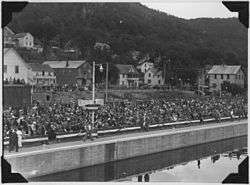
An old photograph dated September 1935 and captioned "Photograph of crowd onshore assembled for Alma, WI dam dedication."
The lock and dam was constructed and placed in operation in May 1935. There were ten major injuries and three deaths recorded during construction of the facility. Its last major rehabilitation was from 1988 to 1994.

Aerial view of Lock and Dam No. 4
External links
| Wikimedia Commons has media related to Mississippi River Lock and Dam number 4. |
- U.S. Army Corps of Engineers, St. Paul District: Lock and Dam 4
- U.S. Army Corps of Engineers, St. Paul District: Lock and Dam 4 brochure
- Survey number HAER WI-47 - Upper Mississippi River 9-Foot Channel, Lock & Dam No. 4, Alma, Buffalo County, WI
| Locks and dams of the Upper Mississippi River | ||
|---|---|---|
| Upstream: Lock and Dam No. 3 |
Downstream: Lock and Dam No. 5 | |
This article is issued from Wikipedia - version of the 2/12/2016. The text is available under the Creative Commons Attribution/Share Alike but additional terms may apply for the media files.