Mansfield, New York
| Mansfield, New York | |
|---|---|
| Town | |
 Mansfield Location within the state of New York | |
| Coordinates: 42°18′36″N 78°45′24″W / 42.31000°N 78.75667°WCoordinates: 42°18′36″N 78°45′24″W / 42.31000°N 78.75667°W | |
| Country | United States |
| State | New York |
| County | Cattaraugus |
| Government | |
| • Type | Town Council |
| • Town Supervisor | Robert C. Keis, Sr. (R) |
| • Town Council |
Members' List
|
| Area | |
| • Total | 40.2 sq mi (104.0 km2) |
| • Land | 40.1 sq mi (103.9 km2) |
| • Water | 0.04 sq mi (0.1 km2) |
| Elevation | 1,873 ft (571 m) |
| Population (2010) | |
| • Total | 808 |
| • Density | 20/sq mi (7.8/km2) |
| Time zone | Eastern (EST) (UTC-5) |
| • Summer (DST) | EDT (UTC-4) |
| FIPS code | 36-45161 |
| GNIS feature ID | 0979193 |
| Website |
mansfieldny |
Mansfield is a town in Cattaraugus County, New York, United States. The population was 808 at the 2010 census.[1] The name was thought to be that of a noble family in England.
The town is centrally located in Cattaraugus County, north of Little Valley.
History
The area was first settled around 1817. The town of Mansfield was formed in 1830 from part of the town of Town of Little Valley. The town was first called "Cecilius". The name "Mansfield" was adopted in 1831.
Geography
According to the United States Census Bureau, the town has a total area of 40.2 square miles (104.0 km2), of which 40.1 square miles (103.9 km2) is land and 0.04 square miles (0.1 km2), or 0.08%, is water.[1]
The town is primarily served by county roads. Cattaraugus County Route 14 (Toad Hollow Road) runs from south to north through the town, while Cattaraugus County Route 13 (Maples Road) runs west to east in the northern part of the town, and County Route 15 (Dublin Road) runs along the southern part of the town. New York State Route 242 passes across the southeast corner of the town and New York State Route 353 through a small portion of the southwest corner.
Mansfield Creek flows across the north part of the town, and Little Valley Creek crosses the southwest corner. The two creeks follow a similar path in opposite directions, separated by the Saint Lawrence River Divide.
Adjacent towns and areas
Demographics
| Historical population | |||
|---|---|---|---|
| Census | Pop. | %± | |
| 1830 | 378 | — | |
| 1840 | 942 | 149.2% | |
| 1850 | 1,057 | 12.2% | |
| 1860 | 1,265 | 19.7% | |
| 1870 | 1,135 | −10.3% | |
| 1880 | 1,106 | −2.6% | |
| 1890 | 1,022 | −7.6% | |
| 1900 | 968 | −5.3% | |
| 1910 | 912 | −5.8% | |
| 1920 | 717 | −21.4% | |
| 1930 | 661 | −7.8% | |
| 1940 | 620 | −6.2% | |
| 1950 | 672 | 8.4% | |
| 1960 | 632 | −6.0% | |
| 1970 | 605 | −4.3% | |
| 1980 | 784 | 29.6% | |
| 1990 | 724 | −7.7% | |
| 2000 | 800 | 10.5% | |
| 2010 | 808 | 1.0% | |
| Est. 2014 | 818 | [2] | 1.2% |
As of the census[4] of 2000, there were 800 people, 305 households, and 234 families residing in the town. The population density was 20.2 people per square mile (7.8/km²). There were 540 housing units at an average density of 13.6 per square mile (5.3/km²). The racial makeup of the town was 98.88% White, 0.12% (one person) African American, 0.75% (six people) Native American, 0.12% (one person) Asian, and 0.12% (one person) from two or more races. Hispanic or Latino of any race were 0.25% of the population.
There were 305 households out of which 33.8% had children under the age of 18 living with them, 64.3% were married couples living together, 6.6% had a female householder with no husband present, and 23.0% were non-families. 19.3% of all households were made up of individuals and 6.9% had someone living alone who was 65 years of age or older. The average household size was 2.61 and the average family size was 3.00.
In the town the population was spread out with 27.9% under the age of 18, 6.3% from 18 to 24, 27.8% from 25 to 44, 27.4% from 45 to 64, and 10.8% who were 65 years of age or older. The median age was 38 years. For every 100 females there were 108.3 males. For every 100 females age 18 and over, there were 103.9 males.
The median income for a household in the town was $36,420, and the median income for a family was $37,500. Males had a median income of $27,614 versus $24,750 for females. The per capita income for the town was $21,700. About 6.3% of families and 8.0% of the population were below the poverty line, including 7.8% of those under age 18 and 2.4% of those age 65 or over.
Notable people
- Anna Maynard Barbour, best-selling fiction author
- Owen Vincent Coffin, 56th governor of Connecticut
Communities and locations in Mansfield
- Dobbins Memorial State Forest – a state forest in the southern part of the town.
- Eddyville – a hamlet in the north part of the town on County Road 14. The Mansfield town hall is in Eddyville, as is the town's only currently operating church, the nondenominational Solomon's Porch Ministries.
- Eddyville Corners – The spot where County Roads 13 and 14 converge, north of Eddyville and west of Maples. A now-abandoned Baptist church (whose congregation has since relocated to Little Valley) is at this spot, as is a state-operated fish stocking outlet on Mansfield Creek.
- Five Points – A location southwest of Eddyville near the town center on County Road 14. Five Points is the location of a county-operated landfill.
- Maples – A hamlet east of Eddyville on County Road 13. The Mansfield fire department and highway barns are in Maples.
- Orlando – A mostly unpopulated hamlet near the east town line on County Road 13.
References
- 1 2 "Geographic Identifiers: 2010 Demographic Profile Data (G001): Mansfield town, Cattaraugus County, New York". U.S. Census Bureau, American Factfinder. Retrieved October 28, 2014.
- ↑ "Annual Estimates of the Resident Population for Incorporated Places: April 1, 2010 to July 1, 2014". Retrieved June 4, 2015.
- ↑ "Census of Population and Housing". Census.gov. Retrieved June 4, 2015.
- ↑ "American FactFinder". United States Census Bureau. Retrieved 2008-01-31.
External links
- Town of Mansfield official website
- Early history of Mansfield, NY
- Little Valley Area Chamber of Commerce
Municipalities and communities of Cattaraugus County, New York, United States | ||
|---|---|---|
| Cities | 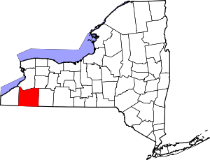 | |
| Towns |
| |
| Villages | ||
| CDPs | ||
| Other hamlets | ||
| Indian reservations | ||
| Footnotes |
| |