Portville (village), New York
| Portville, New York | |
|---|---|
| Village | |
|
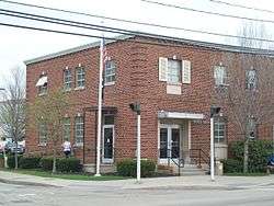
U.S. Post Office, Portville, NY, April 2010 | |
 Portville Location within the state of New York | |
| Coordinates: 42°2′14″N 78°20′12″W / 42.03722°N 78.33667°WCoordinates: 42°2′14″N 78°20′12″W / 42.03722°N 78.33667°W | |
| Country | United States |
| State | New York |
| County | Cattaraugus |
| Town | Portville |
| Area | |
| • Total | 0.80 sq mi (2.08 km2) |
| • Land | 0.80 sq mi (2.08 km2) |
| • Water | 0.0 sq mi (0.0 km2) |
| Elevation | 1,430 ft (436 m) |
| Population (2010) | |
| • Total | 1,014 |
| • Density | 1,264/sq mi (488.1/km2) |
| Time zone | Eastern (EST) (UTC-5) |
| • Summer (DST) | EDT (UTC-4) |
| ZIP code | 14770 |
| Area code(s) | 716 |
| FIPS code | 36-59498 |
| GNIS feature ID | 0961005 |
| Website |
www |
Portville is a village in Cattaraugus County, New York, United States. It is in the southern part of the town of Portville and southeast of Olean. The village population was 1,014 at the 2010 census,[1] out of a population of 3,730 in the entire town of Portville.
History
The community, located along the Allegheny River, was first settled around 1813. The former Genesee Valley Canal reached its southern terminus at Portville. A fire destroyed most of the business district in 1875. The village was incorporated in 1895.
The Portville Free Library and William E. Wheeler House are listed on the National Register of Historic Places.[2]
Notable people
The current mayor is Emily Woodhead. The four village trustees are Helen Worth, Joseph McLarney, Gene Rogers, and Emily Woodhead.
- Amos Humiston, Civil War soldier
- Riki Lindhome, actress, spent most of her childhood in Portville
- Nelson Platt Wheeler, former US congressman from Pennsylvania
Geography
According to the United States Census Bureau, the village has a total area of 0.81 square miles (2.1 km2), all of it land. The village is on the east side of the Allegheny River and is split by Dodge Creek, which flows into the river.
New York State Route 305 and New York State Route 417 pass through the village.
Demographics
| Historical population | |||
|---|---|---|---|
| Census | Pop. | %± | |
| 1870 | 450 | — | |
| 1880 | 683 | 51.8% | |
| 1900 | 748 | — | |
| 1910 | 758 | 1.3% | |
| 1920 | 606 | −20.1% | |
| 1930 | 969 | 59.9% | |
| 1940 | 1,018 | 5.1% | |
| 1950 | 1,151 | 13.1% | |
| 1960 | 1,336 | 16.1% | |
| 1970 | 1,304 | −2.4% | |
| 1980 | 1,136 | −12.9% | |
| 1990 | 1,040 | −8.5% | |
| 2000 | 1,024 | −1.5% | |
| 2010 | 1,014 | −1.0% | |
| Est. 2015 | 978 | [3] | −3.6% |
As of the census[5] of 2000, there were 1,024 people, 416 households, and 270 families residing in the village. The population density was 1,261.8 people per square mile (488.1/km²). There were 454 housing units at an average density of 559.4 per square mile (216.4/km²). The racial makeup of the village was 98.54% White, 0.59% Black or African American, 0.20% Native American, 0.29% from other races, and 0.39% from two or more races. Hispanic or Latino of any race were 0.39% of the population.
There were 416 households out of which 35.8% had children under the age of 18 living with them, 48.6% were married couples living together, 13.5% had a female householder with no husband present, and 34.9% were non-families. 32.2% of all households were made up of individuals and 20.0% had someone living alone who was 65 years of age or older. The average household size was 2.46 and the average family size was 3.11.
In the village the population was spread out with 29.7% under the age of 18, 7.1% from 18 to 24, 25.1% from 25 to 44, 20.0% from 45 to 64, and 18.1% who were 65 years of age or older. The median age was 37 years. For every 100 females there were 80.0 males. For every 100 females age 18 and over, there were 79.6 males.
The median income for a household in the village was $31,210, and the median income for a family was $40,060. Males had a median income of $30,885 versus $21,563 for females. The per capita income for the village was $16,166. About 11.1% of families and 14.8% of the population were below the poverty line, including 21.8% of those under age 18 and 13.3% of those age 65 or over.
References
- ↑ "Geographic Identifiers: 2010 Demographic Profile Data (G001): Portville village, New York". U.S. Census Bureau, American Factfinder. Retrieved October 29, 2014.
- ↑ National Park Service (2009-03-13). "National Register Information System". National Register of Historic Places. National Park Service.
- ↑ "Annual Estimates of the Resident Population for Incorporated Places: April 1, 2010 to July 1, 2015". Retrieved July 2, 2016.
- ↑ "Census of Population and Housing". Census.gov. Retrieved June 4, 2015.
- ↑ "American FactFinder". United States Census Bureau. Retrieved 2008-01-31.
External links
Municipalities and communities of Cattaraugus County, New York, United States | ||
|---|---|---|
| Cities | 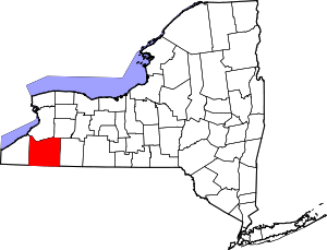 | |
| Towns |
| |
| Villages | ||
| CDPs | ||
| Other hamlets | ||
| Indian reservations | ||
| Footnotes |
| |