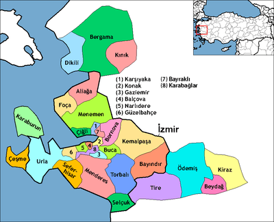
Menderes, İzmir
| Menderes | |
|---|---|
|
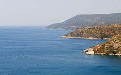
The Aegean Sea from Menderes district | |
 Menderes | |
| Coordinates: 38°15′14″N 27°08′02″E / 38.254°N 27.134°ECoordinates: 38°15′14″N 27°08′02″E / 38.254°N 27.134°E | |
| Country | Turkey |
| Province | Izmir |
| Area[1] | |
| • District | 775.17 km2 (299.29 sq mi) |
| Population (2012)[2] | |
| • Urban | 59,254 |
| • District | 74,831 |
| • District density | 97/km2 (250/sq mi) |
Menderes is a district of İzmir Province in Turkey.
Overview
Menderes district, which is notable for its satsumas, beautiful bays and historical riches, is 20 kilometres (12 miles) from İzmir. The antique city of Lebedos is situated in the western corner of the district in Ürkmez locality. Ruins of Kolophon, Klaros, Notion and Lebedos, which are along the Menderes-Selçuk road are next to each other and make up the important archeological sites of the province. Gümüldür municipality is the region that produces the world-famous tangerine breed of satsumas. Özdere is one of the important tourism resorts of the Aegean coast. Beads of various colors and shapes which are produced by the locals in Görece village are particularly of note. The area was called Cumaovası and was a township in the Konak (Centre) district before it became a district in 1988.
See also
References
- ↑ "Area of regions (including lakes), km²". Regional Statistics Database. Turkish Statistical Institute. 2002. Retrieved 2013-03-05.
- ↑ "Population of province/district centers and towns/villages by districts - 2012". Address Based Population Registration System (ABPRS) Database. Turkish Statistical Institute. Retrieved 2013-02-27.