Mission Woods, Kansas
| Mission Woods, Kansas | |
|---|---|
| City | |
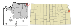 Location within Johnson County and Kansas | |
 KDOT map of Johnson County (legend) | |
| Coordinates: 39°1′59″N 94°36′47″W / 39.03306°N 94.61306°WCoordinates: 39°1′59″N 94°36′47″W / 39.03306°N 94.61306°W | |
| Country | United States |
| State | Kansas |
| County | Johnson |
| Government | |
| • Type | Mayor–Council |
| Area[1] | |
| • Total | 0.10 sq mi (0.26 km2) |
| • Land | 0.10 sq mi (0.26 km2) |
| • Water | 0 sq mi (0 km2) |
| Elevation | 906 ft (276 m) |
| Population (2010)[2] | |
| • Total | 178 |
| • Estimate (2012[3]) | 181 |
| • Density | 1,780.0/sq mi (687.3/km2) |
| Time zone | CST (UTC-6) |
| • Summer (DST) | CDT (UTC-5) |
| ZIP code | 66205 |
| Area code | 913 |
| FIPS code | 20-47425 [4] |
| GNIS ID | 0479023 [5] |
| Website | City Website |
Mission Woods is a city in Johnson County, Kansas, United States, and part of the Kansas City Metropolitan Area. As of the 2010 census, the city population was 178.[6]
History
Mission Woods had its start in the 1930s when a developer laid out the subdivision and started building.[7] It was named from a Native American mission established at the site in the 19th century, and from the scenic wooded setting.[8]
Mission Woods became a Google Fiber "fiberhood" in 2014, with installation and service beginning.
Geography
Mission Woods is located at 39°1′59″N 94°36′47″W / 39.03306°N 94.61306°W (39.033188, -94.613003).[9] According to the United States Census Bureau, the city has a total area of 0.10 square miles (0.26 km2), all of it land.[1]
Demographics
| Historical population | |||
|---|---|---|---|
| Census | Pop. | %± | |
| 1950 | 205 | — | |
| 1960 | 243 | 18.5% | |
| 1970 | 237 | −2.5% | |
| 1980 | 213 | −10.1% | |
| 1990 | 182 | −14.6% | |
| 2000 | 165 | −9.3% | |
| 2010 | 178 | 7.9% | |
| Est. 2015 | 182 | [10] | 2.2% |
| U.S. Decennial Census | |||
2010 census
As of the census[2] of 2010, there were 178 people, 77 households, and 53 families residing in the city. The population density was 1,780.0 inhabitants per square mile (687.3/km2). There were 80 housing units at an average density of 800.0 per square mile (308.9/km2). The racial makeup of the city was 97.8% White, 0.6% African American, and 1.7% Asian.
There were 77 households of which 24.7% had children under the age of 18 living with them, 62.3% were married couples living together, 6.5% had a female householder with no husband present, and 31.2% were non-families. 26.0% of all households were made up of individuals and 16.9% had someone living alone who was 65 years of age or older. The average household size was 2.31 and the average family size was 2.79.
The median age in the city was 54.5 years. 18.5% of residents were under the age of 18; 5.1% were between the ages of 18 and 24; 17.4% were from 25 to 44; 32.7% were from 45 to 64; and 26.4% were 65 years of age or older. The gender makeup of the city was 44.9% male and 55.1% female.
2000 census
As of the census[4] of 2000, there were 165 people, 77 households, and 51 families residing in the city. The population density was 1,519.6 people per square mile (579.2/km²). There were 78 housing units at an average density of 718.3 per square mile (273.8/km²). The racial makeup of the city was 96.97% White, 1.82% African American, 1.21% from other races.
There were 77 households out of which 16.9% had children under the age of 18 living with them, 62.3% were married couples living together, 2.6% had a female householder with no husband present, and 32.5% were non-families. 29.9% of all households were made up of individuals and 16.9% had someone living alone who was 65 years of age or older. The average household size was 2.14 and the average family size was 2.65.
In the city the population was spread out with 18.8% under the age of 18, 1.8% from 18 to 24, 10.3% from 25 to 44, 42.4% from 45 to 64, and 26.7% who were 65 years of age or older. The median age was 54 years. For every 100 females there were 94.1 males. For every 100 females age 18 and over, there were 88.7 males.
The median income for a household in the city was $106,885, and the median income for a family was $181,456. Males had a median income of $100,000 versus $60,625 for females. The per capita income for the city was $68,713. None of the population or families were below the poverty line.
Government
The Mission Woods government consists of a mayor and five council members. The council meets the 1st Tuesday of each month at 7PM.[11]
Libraries
The Johnson County Library serves residents of Mission Woods.
References
- 1 2 "US Gazetteer files 2010". United States Census Bureau. Retrieved 2012-07-06.
- 1 2 "American FactFinder". United States Census Bureau. Retrieved 2012-07-06.
- ↑ "Population Estimates". United States Census Bureau. Retrieved 2013-05-29.
- 1 2 "American FactFinder". United States Census Bureau. Retrieved 2008-01-31.
- ↑ "US Board on Geographic Names". United States Geological Survey. 2007-10-25. Retrieved 2008-01-31.
- ↑ "2010 City Population and Housing Occupancy Status". U.S. Census Bureau. Retrieved April 6, 2011.
- ↑ "History". City of Mission Woods, Kansas. Retrieved 12 June 2014.
- ↑ "Mission Hills & Mission Woods, Kansas". JoCoHistory. Johnson County Museum. Retrieved 12 June 2014.
- ↑ "US Gazetteer files: 2010, 2000, and 1990". United States Census Bureau. 2011-02-12. Retrieved 2011-04-23.
- ↑ "Annual Estimates of the Resident Population for Incorporated Places: April 1, 2010 to July 1, 2015". Retrieved July 2, 2016.
- ↑ Mission Woods - Directory of Public Officials
External links
| Wikimedia Commons has media related to Mission Woods, Kansas. |
Municipalities and communities of Johnson County, Kansas, United States | ||
|---|---|---|
| Cities | 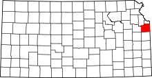 | |
| Unincorporated communities | ||
| Townships | ||
| Footnotes | ‡This populated place also has portions in an adjacent county or counties | |
Kansas City metropolitan area's cities and counties | ||
|---|---|---|
| Central city |  | |
| Largest cities (over 100,000 in 2000) | ||
| Medium-sized cities (10,000 to 100,000 in 2000) | ||
| Smaller Cities (between 5,000 and 9,900 in 2010) | ||
| Counties | ||