Odessa, Missouri
| Odessa, Missouri | |
|---|---|
| City | |
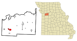 Location of Odessa, Missouri | |
| Coordinates: 38°59′49″N 93°57′18″W / 38.99694°N 93.95500°WCoordinates: 38°59′49″N 93°57′18″W / 38.99694°N 93.95500°W | |
| Country | United States |
| State | Missouri |
| County | Lafayette |
| Area[1] | |
| • Total | 4.13 sq mi (10.70 km2) |
| • Land | 4.10 sq mi (10.62 km2) |
| • Water | 0.03 sq mi (0.08 km2) |
| Elevation | 932 ft (284 m) |
| Population (2010)[2] | |
| • Total | 5,300 |
| • Estimate (2012[3]) | 5,242 |
| • Density | 1,292.7/sq mi (499.1/km2) |
| Time zone | Central (CST) (UTC-6) |
| • Summer (DST) | CDT (UTC-5) |
| ZIP code | 64076 |
| Area code(s) | 816 |
| FIPS code | 29-54038[4] |
| GNIS feature ID | 0723697[5] |
| Website | Odessa Missouri |
Odessa is a city in Lafayette County, Missouri, United States. The population was 5,300 at the 2010 census.
History
Odessa was platted in 1878, and named after Odessa, in Ukraine.[6] A post office called Odessa has been in operation since 1879.[7]
Geography
Odessa is located at 38°59′49″N 93°57′18″W / 38.996962°N 93.954975°W.[8]
According to the United States Census Bureau, the city has a total area of 4.13 square miles (10.70 km2), of which, 4.10 square miles (10.62 km2) is land and 0.03 square miles (0.08 km2) is water.[1]
Odessa is located roughly 45 minutes from downtown Kansas City, Missouri and about three hours from St. Louis, Missouri.
Demographics
| Historical population | |||
|---|---|---|---|
| Census | Pop. | %± | |
| 1880 | 100 | — | |
| 1890 | 1,272 | 1,172.0% | |
| 1900 | 1,445 | 13.6% | |
| 1910 | 1,531 | 6.0% | |
| 1920 | 1,786 | 16.7% | |
| 1930 | 1,861 | 4.2% | |
| 1940 | 1,881 | 1.1% | |
| 1950 | 1,969 | 4.7% | |
| 1960 | 2,034 | 3.3% | |
| 1970 | 2,839 | 39.6% | |
| 1980 | 3,088 | 8.8% | |
| 1990 | 3,695 | 19.7% | |
| 2000 | 4,818 | 30.4% | |
| 2010 | 5,300 | 10.0% | |
| Est. 2015 | 5,178 | [9] | −2.3% |
2010 census
As of the census[2] of 2010, there were 5,300 people, 2,077 households, and 1,427 families residing in the city. The population density was 1,292.7 inhabitants per square mile (499.1/km2). There were 2,280 housing units at an average density of 556.1 per square mile (214.7/km2). The racial makeup of the city was 94.8% White, 1.4% African American, 0.4% Native American, 0.4% Asian, 0.3% from other races, and 2.6% from two or more races. Hispanic or Latino of any race were 2.2% of the population.
There were 2,077 households of which 37.1% had children under the age of 18 living with them, 49.1% were married couples living together, 14.3% had a female householder with no husband present, 5.3% had a male householder with no wife present, and 31.3% were non-families. 26.1% of all households were made up of individuals and 11.2% had someone living alone who was 65 years of age or older. The average household size was 2.52 and the average family size was 3.00.
The median age in the city was 35.2 years. 27% of residents were under the age of 18; 8.8% were between the ages of 18 and 24; 26.6% were from 25 to 44; 22.8% were from 45 to 64; and 14.8% were 65 years of age or older. The gender makeup of the city was 48.2% male and 51.8% female.
2000 census
As of the census[4] of 2000, there were 4,818 people, 1,887 households, and 1,290 families residing in the city. The population density was 1,381.7 people per square mile (533.0/km²). There were 2,011 housing units at an average density of 576.7 per square mile (222.5/km²). The racial makeup of the city was 97.09% White, 1.18% African American, 0.27% Native American, 0.10% Asian, 0.04% Pacific Islander, 0.33% from other races, and 0.98% from two or more races. Hispanic or Latino of any race were 0.73% of the population.
There were 1,887 households out of which 36.5% had children under the age of 18 living with them, 53.8% were married couples living together, 10.9% had a female householder with no husband present, and 31.6% were non-families. 26.7% of all households were made up of individuals and 11.7% had someone living alone who was 65 years of age or older. The average household size was 2.52 and the average family size was 3.07.
In the city the population was spread out with 28.2% under the age of 18, 9.0% from 18 to 24, 30.9% from 25 to 44, 17.4% from 45 to 64, and 14.4% who were 65 years of age or older. The median age was 34 years. For every 100 females there were 93.8 males. For every 100 females age 18 and over, there were 89.4 males.
The median income for a household in the city was $34,007, and the median income for a family was $40,000. Males had a median income of $35,476 versus $23,047 for females. The per capita income for the city was $17,455. About 8.4% of families and 9.9% of the population were below the poverty line, including 10.0% of those under age 18 and 14.9% of those age 65 or over.
Education
Odessa is home of the Odessa R-7 School District. The school's mascot is the bulldog. The colors of the school are red and black.
Government
The City of Odessa is governed by six-member Board of Aldermen (City Council) who represent a total of three different Wards. Aldermen serve alternating two year terms with no limits on how many terms they can serve. Adam Couch is the Mayor and at age 29, he is the youngest Mayor in the history of Odessa. The Mayor serves 2 year terms with no limits on how many terms.
Odessa is a Missouri "Fourth Class" city.
Notable residents
- The composer H. Owen Reed was born in Odessa on June 17, 1910.
- Joe C. Specker, Army sergeant and (posthumous) Medal of Honor recipient in World War II.
- Actor Holmes Osborne is a graduate of Odessa High School.
- Emily Hedicke was a lifeguard on Hole in the Wall.
- Gymnast Terin Humphrey, who won an individual silver medal on the uneven bars, and another silver with the US women's team in the all-around competition at the 2004 Olympics in Athens, is a graduate of Odessa High School.
- Arizona Diamondbacks' pitcher Brad Ziegler, who made his major-league debut in May 2008, is a graduate of Odessa High School.
- Dean Vogelaar, past Vice-President and Director of Public Relations for the Kansas City Royals, is a graduate of Odessa High School.
- Tonya Evinger, mixed martial artist, was born in Odessa on June 4, 1981.
References
- 1 2 "US Gazetteer files 2010". United States Census Bureau. Archived from the original on January 24, 2012. Retrieved 2012-07-08.
- 1 2 "American FactFinder". United States Census Bureau. Retrieved 2012-07-08.
- ↑ "Population Estimates". United States Census Bureau. Archived from the original on June 17, 2013. Retrieved 2013-05-30.
- 1 2 "American FactFinder". United States Census Bureau. Archived from the original on September 11, 2013. Retrieved 2008-01-31.
- ↑ "US Board on Geographic Names". United States Geological Survey. 2007-10-25. Retrieved 2008-01-31.
- ↑ Eaton, David Wolfe (1916). How Missouri Counties, Towns and Streams Were Named. The State Historical Society of Missouri. p. 183.
- ↑ "Post Offices". Jim Forte Postal History. Retrieved 25 October 2016.
- ↑ "US Gazetteer files: 2010, 2000, and 1990". United States Census Bureau. 2011-02-12. Retrieved 2011-04-23.
- ↑ "Annual Estimates of the Resident Population for Incorporated Places: April 1, 2010 to July 1, 2015". Retrieved July 2, 2016.
- ↑ "Census of Population and Housing". Census.gov. Archived from the original on May 11, 2015. Retrieved June 4, 2015.
External links
- Parry, Albert (Spring 1944). "US towns named Odessa". Russian Review. 3 (2): 36–40. doi:10.2307/125407.
- Historic maps of Odessa in the Sanborn Maps of Missouri Collection at the University of Missouri
Municipalities and communities of Lafayette County, Missouri, United States | ||
|---|---|---|
| Cities | 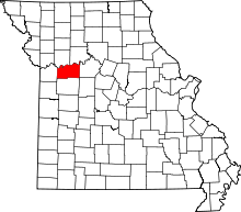 | |
| Villages | ||
| Townships | ||
| Unincorporated communities | ||
| Ghost towns | ||
| Footnotes | ‡This populated place also has portions in an adjacent county or counties | |
Kansas City metropolitan area's cities and counties | ||
|---|---|---|
| Central city |  | |
| Largest cities (over 100,000 in 2000) | ||
| Medium-sized cities (10,000 to 100,000 in 2000) | ||
| Smaller Cities (between 5,000 and 9,900 in 2010) | ||
| Counties | ||