Třebenice (Třebíč District)
| Třebenice | ||
|---|---|---|
| Municipality | ||
 | ||
| ||
 Třebenice | ||
| Coordinates: 49°10′11″N 16°0′27″E / 49.16972°N 16.00750°ECoordinates: 49°10′11″N 16°0′27″E / 49.16972°N 16.00750°E | ||
| Country |
| |
| Region | Vysočina | |
| District | Třebíč | |
| Area | ||
| • Total | 11.67 km2 (4.51 sq mi) | |
| Elevation | 495 m (1,624 ft) | |
| Population (2007) | ||
| • Total | 433 | |
| • Density | 37/km2 (96/sq mi) | |
| Postal code | 675 52 | |
| Website | http://www.hrotovicko.cz/trebenice/ | |
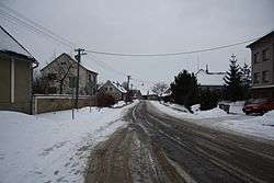
Třebenice is a village and municipality (obec) in Třebíč District in the Vysočina Region of the Czech Republic.
The municipality covers an area of 11.67 square kilometres (4.51 sq mi), and has a population of 433 (as at 1 January 2007).
Třebenice lies approximately 11 kilometres (7 mi) south-east of Třebíč, 40 km (25 mi) south-east of Jihlava, and 154 km (96 mi) south-east of Prague.
References
| Wikimedia Commons has media related to Třebenice (Třebíč District). |
This article is issued from Wikipedia - version of the 4/7/2016. The text is available under the Creative Commons Attribution/Share Alike but additional terms may apply for the media files.