Panchgani
| Panchgani पंचगणि / पाचगणी Gani | |
|---|---|
| Hill station | |
|
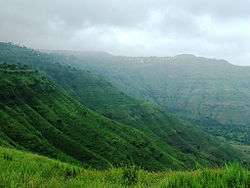
View of Panchgani Hills | |
| Nickname(s): Paachgani | |
 Panchgani Location in Maharashtra, India | |
| Coordinates: 17°55′30″N 73°48′00″E / 17.925°N 73.8°ECoordinates: 17°55′30″N 73°48′00″E / 17.925°N 73.8°E | |
| Country |
|
| State | Maharashtra |
| District | Satara |
| Elevation | 1,293 m (4,242 ft) |
| Population (2001) | |
| • Total | 13,280 |
| Languages | |
| • Official | Marathi |
| Time zone | IST (UTC+5:30) |
Panchgani also called Paachgani is a famous hill station and municipal council in Satara district in Maharashtra, India. It is renowned for the many premier residential educational institutions.[1]
History
Scenic Panchgani was discovered by the British during the British Raj as a summer resort, and a superintendent named John Chesson was placed in charge of the hill station in the 1860s. He is credited with planting many plant species from the western world in Panchgani, including silver oak and poinsettia, which have flourished since then in Panchgani. Mahabaleshwar was the summer resort of choice for the British, but it was uninhabitable during the monsoons. Panchgani was developed as a retirement place for the British because it remained pleasant throughout the year. John Chesson was deputed to find a suitable place. He surveyed the hills in this region in the company of Mr Rustomji Dubash, and finally decided on this nameless area in the vicinity of the five villages:Dhandeghar, Godavli, Amral, Khingar, and Taighat. The place was aptly named Panchgani, and Chesson was made Superintendent.
To develop the infrastructure, Chesson encouraged various professionals - tailors, dhobis, butchers,vegetable vendors, building contractors etc. to also settle in Panchgani. The area below the bazaar was allotted to them, and is known as the gaothan. Chesson is buried in the graveyard of St. Peter's Church. In 1971 or '72, his death centenary was observed in a big way when for the first time, the town folk and the schools participated together in a ceremony to remember the founder of Panchgani.
Geography and climate
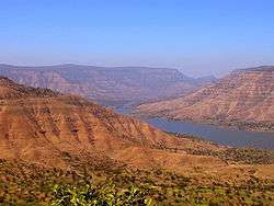
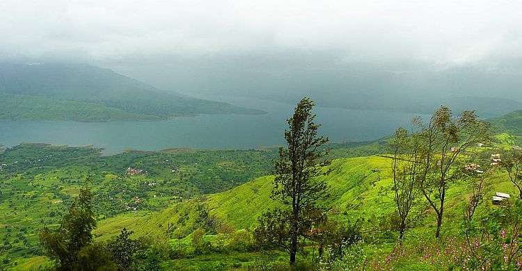
Panchgani is nestled at middle of five hills in the Sahyādri mountain ranges, also there are five villages around the Pachgani are Dandeghar, Khingar, Godwali, Amral & Taighat. The Krishnā River flows nearby which made the lake of Dhom Dam on the Krishna 9 km from Wai.
Where to Stay
Panchgani is about one hours' drive from kaas plateau. Two hours away from Pune. Panchgani is also a great diversion for travellers to and from Goa. There are various hotels, home stays and campsites to choose to stay at. Some of the notable ones are the 3 star luxury Ravine Hotel, the heritage Prospect hotel and the campsite Eco Camp for backpackers and paragliders.
BOUNDARIES:- The distances of Panchgani from major cities are as follows:
From Mumbai - 285 km, From Pune - 100 km From Mahabaleshwar - 18 km, From Satara - 45 km & From Wai - 10 km
The east of the Pachgani is Wai, Bavdhan & Nagewadi dam, at west there is Gureghar,at south is Khingar & Rajpuri,& on north is Dhom Dam.
The temperature in Panchgani is around 12C during the winter, and sometimes reaches 34C during the summer; however the humidity level is very low. The Monsoon rains hit here hardest and the rainy season spans between June and February, allowing the region three months of relatively dry and sunny spring.
The five hills surrounding Panchgani are topped by a volcanic plateau, which is the second highest in Asia after the Tibetan plateau. These plateaus, alternatively known as "table land", are a part of the Deccan Plateau and they were raised by pressure between the earth plates. The area has high seismic activity, with an epicenter near Koynānagar where the Koynanagar Dam and a hydroelectric power plant have been built.
| Climate data for Panchgani | |||||||||||||
|---|---|---|---|---|---|---|---|---|---|---|---|---|---|
| Month | Jan | Feb | Mar | Apr | May | Jun | Jul | Aug | Sep | Oct | Nov | Dec | Year |
| Average high °C (°F) | 23.9 (75) |
25.1 (77.2) |
28.9 (84) |
31.2 (88.2) |
31.3 (88.3) |
24.2 (75.6) |
20.7 (69.3) |
20.8 (69.4) |
21.3 (70.3) |
24.7 (76.5) |
23.2 (73.8) |
23.1 (73.6) |
24.87 (76.77) |
| Average low °C (°F) | 14.2 (57.6) |
15.3 (59.5) |
18.5 (65.3) |
20.6 (69.1) |
20.1 (68.2) |
17.2 (63) |
17.1 (62.8) |
16.4 (61.5) |
16.4 (61.5) |
17.3 (63.1) |
14.7 (58.5) |
13.9 (57) |
16.81 (62.26) |
| Average precipitation mm (inches) | 4.1 (0.161) |
1.3 (0.051) |
4.8 (0.189) |
25.9 (1.02) |
43.9 (1.728) |
261.1 (10.28) |
697.2 (27.449) |
404.1 (15.909) |
221.5 (8.72) |
126.7 (4.988) |
66.0 (2.598) |
8.4 (0.331) |
1,865 (73.424) |
| Source: Government of Maharashtra | |||||||||||||
Demographics
According to 2001 census in India,[2] Panchgani then had a population of 13,280. Males constituted 57% of the population, and females, 43%. Literacy in Panchgani was 82%, (which is higher than the national average of 65%), male and female literacy being 87% and 75%, respectively. As of 2001, 9% of the population was under 6 years of age.
Tourist attractions
Sydney Point: This point is situated on a hillock facing the Krishna Valley. One can see from here the glittering waters of the Dhom Dam, and Pāndavgad and Mandhārdeo. Sydney point is about 2 km from Panchgani Bus stand.
Table Land: This flat large expanse of laterite rock is the second longest mountain plateau in Asia. Some spacious caves including the “Devil's Kitchen” are visible from here.
Parsi Point: This scenic point is situated on the way to Mahabaleshwar, and overlooks the Krishna valley and the blue shiny waters of the Dhom Dam.
Devil's Kitchen: Situated at the south of the table land, the Devil's Kitchen has a mythology associated with it: It is believed that the Pāndavas of the Mahābhārat epic had stayed here for a while. Pāndavgad Caves (near Wāi) are also said to be built by them then.
Mala's Fruit Products:Mala's is one of the best Jam developers in the history of India.Mala's introduced the word 'JAM' in India. Panchgani is the hometown of Mala's Fruit.
Mapro Garden: Situated on the curvaceous roads between Panchgani and Mahabaleshwar, it is easily accessible by buses originating both from Panchgani and Mahabaleshwar.
General information
Panchgani attracts many tourists throughout the year. A well-known Ganesh Temple is located close by in Wai. Panchgani's famous 'table land' has been the location for many Indian Movies, recently the location for the acclaimed movie "Taare Zameen Par" and "Agent Vinod"
One Dr. Rustomji Bomanji Billimoria set up a tuberculosis sanatorium in Panchgani in the 1940s. (The Government of India awarded him the Padma Bhushan Award in 1961.) Panchgani has grown in popularity as a convalescence center.
In recent times, Panchgani has been facing ecological problems because of poorly controlled commercial activities, excessive traffic, and temperature inversion (because of humidity) from the new dams which have been built in the vicinity for water storage.
Panchgani was originally settled by retired Britishers, but since it was pleasant throughout the year, others also settled there. A number of attempts to start schools were made in the 19th century. In the 1890s The Kimmins School was started for European boys and girls. In 1902, the boys section separated to become The European Boys High School, now known as Saint Peter's high school, and Kimmins became an exclusively girls school. Also in the 1890s, one or two years after Kimmins was started, the Roman Catholic Order of nuns known as Daughters of The Cross started The St. Joseph's Convent Girls High School. All three boarding schools were modeled on the English Public Schools of that time, and were affiliated to Cambridge University. The Board exams would be held in December, the question papers being sent from England by sea. The answer papers sent back by sea to England, and the results declared some time in June.
Shortly afterward, other communities started their own schools. These prepared students for the Matriculation examination of the Bombay Presidency. The Parsi School, the first of these schools, later became the Billimoria School. The Muslim School became the Union High School, and is now known as Anjuman School. Both these schools were modelled on the English Public Schools. In between was started the Hindu High School, now known as the Sanjeevan Vidhyalaya. This was modelled on Rabindranath Tagore's Santiniketan. A retired teacher from the Parsi High School, Mr. S. M. Batha started his own Batha School, which is still running well. In the 1950s the newly settled Bahá'í community started their own little Bahá'í school, which was renamed the New Era High School. It remained insignificant among the other schools till about thirty years, when it began expanding. Now, New Era School is probably the biggest school in Panchgani.
The high standards maintained by these schools encouraged others to set up schools as commercial ventures. As a result, the number of schools in Panchgani is almost forty. Some are very good, while some are not. Nevertheless, all appear to be thriving.
The fresh air and invigorating climate of Panchgani made it a good place for convalescence, especially for those suffering from tuberculosis. Thus Panchgani became famous as a health resort. A well known TB specialist from Bombay, Dr. Rustom Billimoria set up the Bel Air Sanatorium, also known as Dalkieth as a centre for the treatment of Tuberculosis, with the help of his son, Dr. Bomy Billimoria, an eminent surgeon. Till the advent of antibiotics, Dalkieth was the premier place for the treatment of tuberculosis in the whole of the Bombay Presidency.
Until the 1980s, Panchgani was almost entirely an educational centre and a health resort, with only the overflow of tourists from Mahabaleshwar coming. Now the whole picture has changed, and Panchgani is booming for better or for worse. Along with the prosperity for its people has come ecological degradation.
Schools
Panchgani is known for its many boarding schools established since the late 19th century. They attract students from the nearby cities of Mumbai and Pune, and also from abroad. One of the most famous of those students is Farrokh Bulsara, who was at Saint Peter's boarding school from 1953 to 1958, where his musical talent was spotted; he became famous a few years later as Freddie Mercury. Another well known former student of the Panchgani region is Kajol, a popular Indian actress known for her extensive work in Hindi film, who went to St. Joseph's Convent School.
Strawberry Festival Panchgani
Panchgani is not only famous as a hill station but it is also famous for the strawberry farms. An event of Strawberry Festival is held every year in summer.
International venue
The global charity Initiatives of Change opened "a centre for introspection and dialogue", a 68-acre campus called Asia Plateau at Panchgani in 1967. Over the past four decades Asia Plateau has been used for holding training programmes and conferences of Initiatives of Change, particularly to address issues of corruption and governance within companies and public institutions. On certain occasions, the centre is used for programmes of like-minded institutions.[3] It is also running a model farm and rural training centre called Grampari, aiming at propagating good practices in the Indian villages, in order to foster hygiene, local democracy and economic development.
References
- ↑ "Panchgani". India: Puneri Travellers. 20 December 2014.
- ↑ "Census of India 2001: Data from the 2001 Census, including cities, villages and towns (Provisional)". Census Commission of India. Archived from the original on 2004-06-16. Retrieved 2008-11-01.
- ↑ http://www.iofc.org/centres
| Wikimedia Commons has media related to Panchgani. |
Satara district topics | ||
|---|---|---|
| History |
|  |
| Battles | ||
| Rivers | ||
| Dams | ||
| Lakes |
| |
| Ghats | ||
| Caves | ||
| Cities and towns | ||
| Villages | ||
| Places to see |
| |
| Monuments | ||
| Transport | ||
| Education | ||
| Lok Sabha constituencies | ||
| Vidhan Sabha constituencies | ||
| Stadiums and Sports venues |
| |
| Culture | ||
| Topics | |||||||||||||||||||||||
|---|---|---|---|---|---|---|---|---|---|---|---|---|---|---|---|---|---|---|---|---|---|---|---|
| Regions | |||||||||||||||||||||||
| Divisions and Districts |
| ||||||||||||||||||||||
| Million-plus cities in Maharashtra | |||||||||||||||||||||||
| Other cities with municipal corporations | |||||||||||||||||||||||
Portal: Maharashtra | |||||||||||||||||||||||