Philbrook, Minnesota
| Philbrook, Minnesota | |
|---|---|
| Unincorporated community | |
 Philbrook, Minnesota  Philbrook, Minnesota Location of the community of Philbrook | |
| Coordinates: 46°17′00″N 94°43′01″W / 46.28333°N 94.71694°WCoordinates: 46°17′00″N 94°43′01″W / 46.28333°N 94.71694°W | |
| Country | United States |
| State | Minnesota |
| County | Todd |
| Township | Fawn Lake Township and Villard Township |
| Elevation | 1,250 ft (380 m) |
| Time zone | Central (CST) (UTC-6) |
| • Summer (DST) | CDT (UTC-5) |
| ZIP code | 56479, 56466, 56438 |
| Area code(s) | 218 and 320 |
| GNIS feature ID | 649354[1] |
Philbrook is an unincorporated community in Todd County, Minnesota, United States. It is along Todd County Road 28 near Red Pine Road. Nearby places include Staples, Motley, Cushing, and Browerville.
History
Philbrook began as Riverside in 1859, and the post office was established in 1889, but because the name Riverside was already in use by another post office, the name was changed to Philbrook in 1890. The post office was changed to a rural branch in 1956 and discontinued in 1964. Philbrook had a station of the Northern Pacific Railroad in section 33 of Villard Township.[2] Saint James Catholic Church in Philbrook was closed in 1962.
References
- ↑ "Philbrook, Minnesota". Geographic Names Information System. United States Geological Survey.
- ↑ Upham, Warren (2001). Minnesota Place Names, A Geographical Encyclopedia, 3rd Edition. Saint Paul, Minnesota: Minnesota Historical Society. p. 592. ISBN 0-87351-396-7.
Municipalities and communities of Todd County, Minnesota, United States | ||
|---|---|---|
| Cities | 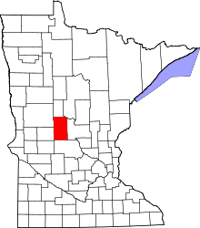 | |
| Townships | ||
| Unincorporated communities | ||
| Footnotes | ‡This populated place also has portions in an adjacent county or counties | |
This article is issued from Wikipedia - version of the 7/28/2016. The text is available under the Creative Commons Attribution/Share Alike but additional terms may apply for the media files.