Motley, Minnesota
| Motley, Minnesota | |
|---|---|
| City | |
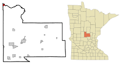 Location of Motley within Morrison County, Minnesota | |
| Coordinates: 46°20′6″N 94°38′45″W / 46.33500°N 94.64583°W | |
| Country | United States |
| State | Minnesota |
| Counties | Morrison, Cass |
| Area[1] | |
| • Total | 1.38 sq mi (3.57 km2) |
| • Land | 1.33 sq mi (3.44 km2) |
| • Water | 0.05 sq mi (0.13 km2) |
| Elevation | 1,230 ft (375 m) |
| Population (2010)[2] | |
| • Total | 671 |
| • Estimate (2012[3]) | 663 |
| • Density | 504.5/sq mi (194.8/km2) |
| Time zone | Central (CST) (UTC-6) |
| • Summer (DST) | CDT (UTC-5) |
| ZIP code | 56466 |
| Area code(s) | 218 |
| FIPS code | 27-44422[4] |
| GNIS feature ID | 0648137[5] |
| Website | www.cityofmotley.com |
Motley is a city in Cass and Morrison counties in the U.S. state of Minnesota. The population was 671 at the 2010 census.[6] The main part of Motley is located within Morrison County; only minor parts of the city extend into Cass County and Todd County.
The Cass County portion of Motley is part of the Brainerd Micropolitan Statistical Area.
History
Motley was laid out in 1874.[7] A post office has been in operation at Motley since 1873.[8]
Geography
According to the United States Census Bureau, the city has a total area of 1.38 square miles (3.57 km2), of which 1.33 square miles (3.44 km2) is land and 0.05 square miles (0.13 km2) is water.[1]
U.S. Highway 10 and Minnesota State Highways 64 and 210 are three of the main routes in the city.
Demographics
| Historical population | |||
|---|---|---|---|
| Census | Pop. | %± | |
| 1880 | 199 | — | |
| 1890 | 525 | 163.8% | |
| 1900 | 404 | −23.0% | |
| 1910 | 428 | 5.9% | |
| 1920 | 396 | −7.5% | |
| 1930 | 397 | 0.3% | |
| 1940 | 368 | −7.3% | |
| 1950 | 435 | 18.2% | |
| 1960 | 430 | −1.1% | |
| 1970 | 351 | −18.4% | |
| 1980 | 444 | 26.5% | |
| 1990 | 441 | −0.7% | |
| 2000 | 585 | 32.7% | |
| 2010 | 671 | 14.7% | |
| Est. 2015 | 646 | [9] | −3.7% |
| U.S. Decennial Census | |||
2010 census
As of the census[2] of 2010, there were 671 people, 305 households, and 167 families residing in the city. The population density was 504.5 inhabitants per square mile (194.8/km2). There were 338 housing units at an average density of 254.1 per square mile (98.1/km2). The racial makeup of the city was 94.5% White, 0.1% African American, 0.4% Native American, 1.6% from other races, and 3.3% from two or more races. Hispanic or Latino of any race were 4.3% of the population.
There were 305 households of which 26.9% had children under the age of 18 living with them, 36.7% were married couples living together, 14.8% had a female householder with no husband present, 3.3% had a male householder with no wife present, and 45.2% were non-families. 38.7% of all households were made up of individuals and 17.1% had someone living alone who was 65 years of age or older. The average household size was 2.20 and the average family size was 2.90.
The median age in the city was 41.1 years. 23.5% of residents were under the age of 18; 10.1% were between the ages of 18 and 24; 19.7% were from 25 to 44; 25.1% were from 45 to 64; and 21.6% were 65 years of age or older. The gender makeup of the city was 48.6% male and 51.4% female.
2000 census
As of the census[4] of 2000, there were 585 people, 258 households, and 167 families residing in the city. The population density was 442.7 people per square mile (171.1/km²). There were 270 housing units at an average density of 204.3 per square mile (79.0/km²). The racial makeup of the city was 97.95% White, 0.17% African American, 0.17% Native American, 0.34% Asian, 0.17% from other races, and 1.20% from two or more races. Hispanic or Latino of any race were 2.05% of the population.
There were 258 households out of which 31.8% had children under the age of 18 living with them, 40.7% were married couples living together, 19.0% had a female householder with no husband present, and 34.9% were non-families. 31.0% of all households were made up of individuals and 16.3% had someone living alone who was 65 years of age or older. The average household size was 2.25 and the average family size was 2.73.
In the city the population was spread out with 27.7% under the age of 18, 10.8% from 18 to 24, 24.8% from 25 to 44, 18.6% from 45 to 64, and 18.1% who were 65 years of age or older. The median age was 33 years. For every 100 females there were 82.2 males. For every 100 females age 18 and over, there were 75.5 males.
The median income for a household in the city was $23,438, and the median income for a family was $29,659. Males had a median income of $24,063 versus $18,824 for females. The per capita income for the city was $12,220. About 19.2% of families and 18.9% of the population were below the poverty line, including 31.9% of those under age 18 and 17.1% of those age 65 or over.
Government
The current Mayor of Motley is Nancy Nieken. The current City Council members include Duane Solga, Robert Sampson, Bruce Mills and Steve Johnson.
References
- 1 2 "US Gazetteer files 2010". United States Census Bureau. Retrieved 2012-11-13.
- 1 2 "American FactFinder". United States Census Bureau. Retrieved 2012-11-13.
- ↑ "Population Estimates". United States Census Bureau. Retrieved 2013-05-28.
- 1 2 "American FactFinder". United States Census Bureau. Retrieved 2008-01-31.
- ↑ "US Board on Geographic Names". United States Geological Survey. 2007-10-25. Retrieved 2008-01-31.
- ↑ "2010 Census Redistricting Data (Public Law 94-171) Summary File". American FactFinder. U.S. Census Bureau, 2010 Census. Retrieved 23 April 2011.
- ↑ Upham, Warren (1920). Minnesota Geographic Names: Their Origin and Historic Significance. Minnesota Historical Society. p. 353.
- ↑ "Morrison County". Jim Forte Postal History. Retrieved 21 July 2015.
- ↑ "Annual Estimates of the Resident Population for Incorporated Places: April 1, 2010 to July 1, 2015". Retrieved July 2, 2016.
External links
Municipalities and communities of Cass County, Minnesota, United States | ||
|---|---|---|
| Cities | 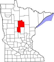 | |
| Townships |
| |
| Unorganized territories | ||
| CDP | ||
| Unincorporated communities | ||
| Indian reservation | ||
| Ghost town | ||
| Footnotes | ‡This populated place also has portions in an adjacent county or counties | |
Municipalities and communities of Morrison County, Minnesota, United States | ||
|---|---|---|
| Cities |  | |
| Townships | ||
| Unincorporated communities | ||
| Indian reservation | ||
| Footnotes | ‡This populated place also has portions in an adjacent county or counties | |
Cities in the Brainerd Lakes area, Minnesota | |||||||
|---|---|---|---|---|---|---|---|
| Core City |  | ||||||
| Surrounding communities |
| ||||||
| Counties | |||||||
† indicates a county seat. ‡ indicates that it is partially in the micropolitan area. § indicates a CDP. | |||||||
Coordinates: 46°20′12″N 94°38′46″W / 46.33667°N 94.64611°W