Cushing, Minnesota
| Cushing, Minnesota | |
|---|---|
| Unincorporated community | |
 Cushing, Minnesota  Cushing, Minnesota Location of the community of Cushing | |
| Coordinates: 46°08′23″N 94°34′37″W / 46.13972°N 94.57694°WCoordinates: 46°08′23″N 94°34′37″W / 46.13972°N 94.57694°W | |
| Country | United States |
| State | Minnesota |
| County | Morrison |
| Township | Cushing Township |
| Elevation | 1,266 ft (386 m) |
| Time zone | Central (CST) (UTC-6) |
| • Summer (DST) | CDT (UTC-5) |
| ZIP code | 56443 |
| Area code(s) | 320 |
| GNIS feature ID | 642566[1] |
Cushing is an unincorporated community in Cushing Township, Morrison County, Minnesota, United States. The community is located along U.S. Highway 10 near Morrison County Road 5, Bear Road. Nearby places include Randall, Little Falls, and Motley.
The community is home to a post office, a park, and two churches. The town hall for surrounding Cushing Township is located at Cushing. The BNSF Railway passes through the community.
History
Cushing was platted in 1907.[2] According to Warren Upham, the community was probably named after Caleb Cushing, a politician from Massachusetts.[2]
References
- ↑ "Cushing, Minnesota". Geographic Names Information System. United States Geological Survey.
- 1 2 Upham, Warren (1920). Minnesota Geographic Names: Their Origin and Historic Significance. Minnesota Historical Society. p. 351.
Municipalities and communities of Morrison County, Minnesota, United States | ||
|---|---|---|
| Cities | 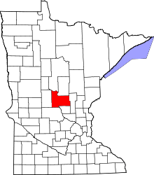 | |
| Townships | ||
| Unincorporated communities | ||
| Indian reservation | ||
| Footnotes | ‡This populated place also has portions in an adjacent county or counties | |
This article is issued from Wikipedia - version of the 10/24/2016. The text is available under the Creative Commons Attribution/Share Alike but additional terms may apply for the media files.