Thiat
| Thiat | ||
|---|---|---|
|
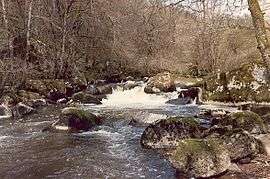
The Brame in winter | ||
| ||
 Thiat | ||
|
Location within Nouvelle-Aquitaine region  Thiat | ||
| Coordinates: 46°16′03″N 0°58′30″E / 46.26750°N 0.97500°ECoordinates: 46°16′03″N 0°58′30″E / 46.26750°N 0.97500°E | ||
| Country | France | |
| Region | Nouvelle-Aquitaine | |
| Department | Haute-Vienne | |
| Arrondissement | Bellac | |
| Canton | Le Dorat | |
| Intercommunality | Basse Marche | |
| Government | ||
| • Mayor (2010–2014) | Jean-Claude Courtioux | |
| Area1 | 11.35 km2 (4.38 sq mi) | |
| Population (2009)2 | 183 | |
| • Density | 16/km2 (42/sq mi) | |
| Time zone | CET (UTC+1) | |
| • Summer (DST) | CEST (UTC+2) | |
| INSEE/Postal code | 87196 / 87320 | |
| Elevation | 123–226 m (404–741 ft) | |
|
1 French Land Register data, which excludes lakes, ponds, glaciers > 1 km² (0.386 sq mi or 247 acres) and river estuaries. 2 Population without double counting: residents of multiple communes (e.g., students and military personnel) only counted once. | ||
.svg.png)
Thiat (Occitan: Tiat) is a commune in the Haute-Vienne department in the Nouvelle-Aquitaine region in west-central France.
Geography
The river Brame forms all of the commune's southern border, then flows into the Gartempe, which forms all of its western border.
Demographics
Inhabitants are known as Thiachons.
See also
References
| Wikimedia Commons has media related to Thiat. |
This article is issued from Wikipedia - version of the 11/11/2016. The text is available under the Creative Commons Attribution/Share Alike but additional terms may apply for the media files.