Bussière-Galant
| Bussière-Galant | ||
|---|---|---|
|
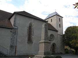
The church of Saint-Martin, in Bussière-Galant | ||
| ||
 Bussière-Galant | ||
|
Location within Nouvelle-Aquitaine region  Bussière-Galant | ||
| Coordinates: 45°37′41″N 1°02′16″E / 45.6281°N 1.0378°ECoordinates: 45°37′41″N 1°02′16″E / 45.6281°N 1.0378°E | ||
| Country | France | |
| Region | Nouvelle-Aquitaine | |
| Department | Haute-Vienne | |
| Arrondissement | Limoges | |
| Canton | Châlus | |
| Intercommunality | Monts de Châlus | |
| Government | ||
| • Mayor (2008–2014) | Martine Beylot | |
| Area1 | 53.86 km2 (20.80 sq mi) | |
| Population (2006)2 | 1,425 | |
| • Density | 26/km2 (69/sq mi) | |
| Time zone | CET (UTC+1) | |
| • Summer (DST) | CEST (UTC+2) | |
| INSEE/Postal code | 87027 / 87230 | |
| Elevation | 338–551 m (1,109–1,808 ft) | |
|
1 French Land Register data, which excludes lakes, ponds, glaciers > 1 km² (0.386 sq mi or 247 acres) and river estuaries. 2 Population without double counting: residents of multiple communes (e.g., students and military personnel) only counted once. | ||

.JPG)
The railway station in Bussière-Galant
Bussière-Galant (Occitan: Bussiéra (Galand)) is a commune in the Haute-Vienne department in the Nouvelle-Aquitaine region in western France.
Inhabitants are known as Bussiérois.
See also
References
| Wikimedia Commons has media related to Bussière-Galant. |
This article is issued from Wikipedia - version of the 11/11/2016. The text is available under the Creative Commons Attribution/Share Alike but additional terms may apply for the media files.