Pierre-Buffière
| Pierre-Buffière | ||
|---|---|---|
|
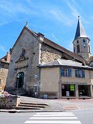
The church in Pierre-Buffière | ||
| ||
 Pierre-Buffière | ||
|
Location within Nouvelle-Aquitaine region  Pierre-Buffière | ||
| Coordinates: 45°41′44″N 1°21′36″E / 45.6956°N 1.36000°ECoordinates: 45°41′44″N 1°21′36″E / 45.6956°N 1.36000°E | ||
| Country | France | |
| Region | Nouvelle-Aquitaine | |
| Department | Haute-Vienne | |
| Arrondissement | Limoges | |
| Canton | Pierre-Buffière | |
| Intercommunality | Braince - Roselle | |
| Government | ||
| • Mayor (2008–2014) | Stéphane Patier | |
| Area1 | 5.75 km2 (2.22 sq mi) | |
| Population (2006)2 | 1,142 | |
| • Density | 200/km2 (510/sq mi) | |
| Time zone | CET (UTC+1) | |
| • Summer (DST) | CEST (UTC+2) | |
| INSEE/Postal code | 87119 / 87260 | |
| Elevation | 240–374 m (787–1,227 ft) | |
|
1 French Land Register data, which excludes lakes, ponds, glaciers > 1 km² (0.386 sq mi or 247 acres) and river estuaries. 2 Population without double counting: residents of multiple communes (e.g., students and military personnel) only counted once. | ||

Pierre-Buffière (Occitan: Pèira Bufiera) is a commune in the Haute-Vienne department in the Nouvelle-Aquitaine region in west-central France.
Geography
The village lies on the left bank of the Briance, which flows westward through the northern part of the commune.
Inhabitants are known as Pierre-Buffiérois.
See also
References
| Wikimedia Commons has media related to Pierre-Buffière. |
This article is issued from Wikipedia - version of the 11/11/2016. The text is available under the Creative Commons Attribution/Share Alike but additional terms may apply for the media files.