Villebadin
| Villebadin | |
|---|---|
 Villebadin | |
|
Location within Normandy region  Villebadin | |
| Coordinates: 48°46′47″N 0°09′19″E / 48.7797°N 0.1553°ECoordinates: 48°46′47″N 0°09′19″E / 48.7797°N 0.1553°E | |
| Country | France |
| Region | Normandy |
| Department | Orne |
| Arrondissement | Argentan |
| Canton | Exmes |
| Intercommunality | Communauté de communes du Pays d'Exmes |
| Government | |
| • Mayor (2008–2014) | Françoise Boisard |
| Area1 | 12.93 km2 (4.99 sq mi) |
| Population (2006)2 | 145 |
| • Density | 11/km2 (29/sq mi) |
| Time zone | CET (UTC+1) |
| • Summer (DST) | CEST (UTC+2) |
| INSEE/Postal code | 61504 / 61310 |
| Elevation |
112–230 m (367–755 ft) (avg. 141 m or 463 ft) |
|
1 French Land Register data, which excludes lakes, ponds, glaciers > 1 km² (0.386 sq mi or 247 acres) and river estuaries. 2 Population without double counting: residents of multiple communes (e.g., students and military personnel) only counted once. | |
Villebadin is a commune in the Orne department in north-western France.
Heraldry
.svg.png) |
The arms of Villebadin are blazoned : Sable, a lion per fess Or and argent, armed and langued gules. |
Manoir
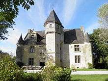
Le manoir d'Argentelles at Villebadin
From 1969 archeologist Robert du Mesnil du Buisson worked to raise funds to restore the local manoir.[1]
See also
References
- ↑ Le Guide Vert Normandie Amaury de Valroger - 2010 Page 217 "À la sortie de Villebadin, prenez à gauche la petite route du manoir d'Argentelles, qui fait découvrir un ravissant paysage campagnard et le manoir lui-même, isolé dans un vaste pré, à droite."
| Wikimedia Commons has media related to Villebadin. |
This article is issued from Wikipedia - version of the 11/16/2014. The text is available under the Creative Commons Attribution/Share Alike but additional terms may apply for the media files.