Suré
| Suré | |
|---|---|
|
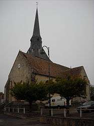
St. Martin's Church | |
 Suré | |
|
Location within Normandy region  Suré | |
| Coordinates: 48°22′11″N 0°23′56″E / 48.3697°N 0.3989°ECoordinates: 48°22′11″N 0°23′56″E / 48.3697°N 0.3989°E | |
| Country | France |
| Region | Normandy |
| Department | Orne |
| Arrondissement | Mortagne-au-Perche |
| Canton | Pervenchères |
| Intercommunality | Communauté de communes du Saosnois |
| Government | |
| • Mayor (2008–2014) | Bernard Michel |
| Area1 | 17.44 km2 (6.73 sq mi) |
| Population (2006)2 | 289 |
| • Density | 17/km2 (43/sq mi) |
| Time zone | CET (UTC+1) |
| • Summer (DST) | CEST (UTC+2) |
| INSEE/Postal code | 61476 / 61360 |
| Elevation |
93–181 m (305–594 ft) (avg. 138 m or 453 ft) |
|
1 French Land Register data, which excludes lakes, ponds, glaciers > 1 km² (0.386 sq mi or 247 acres) and river estuaries. 2 Population without double counting: residents of multiple communes (e.g., students and military personnel) only counted once. | |
Suré is a commune in the Orne department in north-western France.
See also
References
| Wikimedia Commons has media related to Suré. |
This article is issued from Wikipedia - version of the 3/15/2016. The text is available under the Creative Commons Attribution/Share Alike but additional terms may apply for the media files.