York, New York
| York | |
|---|---|
| Town | |
 York Location within the state of New York | |
| Coordinates: 42°51′32″N 77°53′25″W / 42.85889°N 77.89028°WCoordinates: 42°51′32″N 77°53′25″W / 42.85889°N 77.89028°W | |
| Country | United States |
| State | New York |
| County | Livingston |
| Government | |
| • Type | Town Council |
| • Town Supervisor | Gerald L. Deming (D, R) |
| • Town Council |
Members' List
|
| Area | |
| • Total | 49.1 sq mi (127.1 km2) |
| • Land | 49.1 sq mi (127.1 km2) |
| • Water | 0.0 sq mi (0.0 km2) 0% |
| Elevation | 768 ft (234 m) |
| Population (Census 2010)[1] | |
| • Total | 3,397 |
| • Density | 69/sq mi (27/km2) |
| Time zone | Eastern (EST) (UTC-5) |
| • Summer (DST) | EDT (UTC-4) |
| ZIP code | 14592 |
| Area code(s) | 585 |
| FIPS code | 36-84022[1] |
| GNIS feature ID | 0979661[2] |
York is a town in western Livingston County, New York, United States. The population was 3,397 at the 2010 census.[1]
The Abbey of the Genesee in the town's hamlet of Piffard is locally famous due to the production of Monks' Bread.
History
In 1722, the Tuscarora moved north to join other Iroquoian natives, the League of the Iroquois, and settled near modern Piffard. The town was first settled by Europeans around 1800.
The town was formed in 1819 from parts of the towns of Leicester and Caledonia before the establishment of Livingston County. More territory was added from the town of Covington in 1823.
Salt was discovered in 1883 near modern Retsof, leading to the formation of the New York Rock Salt Company. Further discoveries were made subsequently by the Empire Salt Company.
Linwood was added to the National Register of Historic Places in 1997.[3]
Notable people
- Chester A. Arthur, former US President
- Moses Hayden, former US Congressman
- John Chandler Holloway, former Wisconsin State Assemblyman and State Senator
- James Laird, former US Congressman from Nebraska, was born in Fowlerville
- Donald Stewart, former Wisconsin State Assemblyman
Geography
According to the United States Census Bureau, the town has a total area of 49.1 square miles (127 km2), of which, 49.1 square miles (127 km2) of it is land and 0.02% is water.
The west town line borders Genesee County and Wyoming County.
New York State Route 36 (north-south) intersects New York State Route 63 (east-west) at Greigsville. US Route 20 passes along the north town line.
Demographics
| Historical population | |||
|---|---|---|---|
| Census | Pop. | %± | |
| 1820 | 1,729 | — | |
| 1830 | 2,636 | 52.5% | |
| 1840 | 3,049 | 15.7% | |
| 1850 | 2,785 | −8.7% | |
| 1860 | 2,743 | −1.5% | |
| 1870 | 2,564 | −6.5% | |
| 1880 | 2,482 | −3.2% | |
| 1890 | 2,868 | 15.6% | |
| 1900 | 2,730 | −4.8% | |
| 1910 | 2,562 | −6.2% | |
| 1920 | 2,640 | 3.0% | |
| 1930 | 2,349 | −11.0% | |
| 1940 | 2,287 | −2.6% | |
| 1950 | 2,329 | 1.8% | |
| 1960 | 2,695 | 15.7% | |
| 1970 | 3,166 | 17.5% | |
| 1980 | 3,212 | 1.5% | |
| 1990 | 3,513 | 9.4% | |
| 2000 | 3,219 | −8.4% | |
| 2010 | 3,397 | 5.5% | |
| Est. 2014 | 3,325 | [4] | −2.1% |
As of the census[1] of 2000, there were 3,219 people, 1,181 households, and 881 families residing in the town. The population density was 65.6 people per square mile (25.3/km²). There were 1,231 housing units at an average density of 25.1 per square mile (9.7/km²). The racial makeup of the town was 97.42% White, 1.06% African American, 0.09% Native American, 0.56% Asian, and 0.87% from two or more races. Hispanic or Latino of any race were 0.84% of the population.
There were 1,181 households out of which 35.0% had children under the age of 18 living with them, 62.2% were married couples living together, 8.4% had a female householder with no husband present, and 25.4% were non-families. 21.3% of all households were made up of individuals and 9.5% had someone living alone who was 65 years of age or older. The average household size was 2.69 and the average family size was 3.12.
In the town the population was spread out with 26.7% under the age of 18, 6.6% from 18 to 24, 30.6% from 25 to 44, 24.8% from 45 to 64, and 11.4% who were 65 years of age or older. The median age was 38 years. For every 100 females there were 102.6 males. For every 100 females age 18 and over, there were 98.6 males.
The median income for a household in the town was $43,229, and the median income for a family was $50,136. Males had a median income of $34,048 versus $20,430 for females. The per capita income for the town was $19,796. About 1.2% of families and 1.8% of the population were below the poverty line, including none of those under age 18 and 4.4% of those age 65 or over.
Communities and locations in York
- Abbey of the Genesee – A monastery north of Piffard.
- Allens Corners – A location near the west town line.
- Bows Corners – A location southwest of York hamlet.
- Craigs – A hamlet in the western part of the town, west of York hamlet.
- Fraser – A hamlet near the north town line on US-20.
- Greigsville – A hamlet (and census-designated place) on Routes NY-36 and NY-63.
- Greigsville Station – A location south of Greigsville.
- Fowlerville – A hamlet and census-designated place in the northeast corner of the town of York. The name comes from Wells Fowler, an early settler.
- Inverness – A location in the northwest part of the town, west of Fowlerville.
- Linwood–A hamlet and census-designated place A location near the west town line.
- McMillans Corners – A location west of York hamlet.
- Piffard (formerly Piffardinia) – A hamlet (and census-designated place) on NY-63, north of Geneseo. The name is from early settler David Piffard. Westerly was added to the National Register of Historic Places in 1974.[3]
- Retsof – A hamlet (and census-designated place) near the center of the town. Retsof was named for Foster, spelled backwards.
- Retsof Corners – A location south of Retsof on NY-63.
- Rippeys Corners – A location east of Wadsworth.
- Roots Corners – A location south of York hamlet.
- The Forks – A location south of York hamlet.
- Toggletown – A hamlet at the north town line.
- Tryons Corners – A location in the southwest part of the town.
- Wadsworth – A hamlet (and census-designated place) near the south town line on NY-36.
- Walkers Corners – A location southwest of York hamlet.
- York – A hamlet (and census-designated place), also known as York Hamlet, in the north part of the town on NY-36.
References
- 1 2 3 4 "American FactFinder". United States Census Bureau. Retrieved 2008-01-31.
- ↑ "US Board on Geographic Names". United States Geological Survey. 2007-10-25. Retrieved 2008-01-31.
- 1 2 National Park Service (2009-03-13). "National Register Information System". National Register of Historic Places. National Park Service.
- ↑ "Annual Estimates of the Resident Population for Incorporated Places: April 1, 2010 to July 1, 2014". Retrieved June 4, 2015.
- ↑ "Census of Population and Housing". Census.gov. Archived from the original on May 11, 2015. Retrieved June 4, 2015.
External links
Municipalities and communities of Livingston County, New York, United States | ||
|---|---|---|
| Towns | 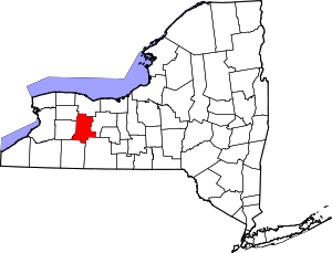 | |
| Villages | ||
| CDPs |
| |
| Other hamlet | ||