Annada, Missouri
| Annada, Missouri | |
|---|---|
| Village | |
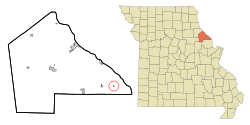 Location of Annada, Missouri | |
| Coordinates: 39°15′42″N 90°49′40″W / 39.26167°N 90.82778°WCoordinates: 39°15′42″N 90°49′40″W / 39.26167°N 90.82778°W | |
| Country | United States |
| State | Missouri |
| County | Pike |
| Area[1] | |
| • Total | 0.06 sq mi (0.16 km2) |
| • Land | 0.06 sq mi (0.16 km2) |
| • Water | 0 sq mi (0 km2) |
| Elevation | 449 ft (137 m) |
| Population (2010)[2] | |
| • Total | 29 |
| • Estimate (2012[3]) | 29 |
| • Density | 483.3/sq mi (186.6/km2) |
| Time zone | Central (CST) (UTC-6) |
| • Summer (DST) | CDT (UTC-5) |
| ZIP code | 63330 |
| Area code(s) | 573 |
| FIPS code | 29-01252[4] |
| GNIS feature ID | 0713302[5] |
Annada is a village in Pike County, Missouri, United States. The population was 29 at the 2010 census.
Geography
Annada is located at 39°15′42″N 90°49′40″W / 39.26167°N 90.82778°W (39.261666, -90.827828).[6]
According to the United States Census Bureau, the village has a total area of 0.06 square miles (0.16 km2), all of it land.[1]
Demographics
| Historical population | |||
|---|---|---|---|
| Census | Pop. | %± | |
| 1930 | 72 | — | |
| 1940 | 110 | 52.8% | |
| 1950 | 93 | −15.5% | |
| 1960 | 105 | 12.9% | |
| 1970 | 109 | 3.8% | |
| 1980 | 70 | −35.8% | |
| 1990 | 70 | 0.0% | |
| 2000 | 48 | −31.4% | |
| 2010 | 29 | −39.6% | |
| Est. 2015 | 29 | [7] | 0.0% |
2010 census
As of the census[2] of 2010, there were 29 people, 16 households, and 7 families residing in the village. The population density was 483.3 inhabitants per square mile (186.6/km2). There were 27 housing units at an average density of 450.0 per square mile (173.7/km2). The racial makeup of the village was 96.6% White and 3.4% African American.
There were 16 households of which 12.5% had children under the age of 18 living with them, 31.3% were married couples living together, 12.5% had a female householder with no husband present, and 56.3% were non-families. 56.3% of all households were made up of individuals and 12.5% had someone living alone who was 65 years of age or older. The average household size was 1.81 and the average family size was 2.71.
The median age in the village was 45.5 years. 10.3% of residents were under the age of 18; 10.3% were between the ages of 18 and 24; 27.5% were from 25 to 44; 41.2% were from 45 to 64; and 10.3% were 65 years of age or older. The gender makeup of the village was 69.0% male and 31.0% female.
2000 census
As of the census[4] of 2000, there were 48 people, 22 households, and 8 families residing in the village. The population density was 790.5 people per square mile (308.9/km²). There were 25 housing units at an average density of 411.7 per square mile (160.9/km²). The racial makeup of the village was 97.92% White, and 2.08% from two or more races.
There were 22 households out of which 22.7% had children under the age of 18 living with them, 36.4% were married couples living together, and 59.1% were non-families. 54.5% of all households were made up of individuals and 27.3% had someone living alone who was 65 years of age or older. The average household size was 2.18 and the average family size was 3.67.
In the village the population was spread out with 27.1% under the age of 18, 4.2% from 18 to 24, 29.2% from 25 to 44, 20.8% from 45 to 64, and 18.8% who were 65 years of age or older. The median age was 40 years. For every 100 females there were 182.4 males. For every 100 age 18 and over, there were 218.2 males.
The median income for a household in the village was $25,500, and the median income for a family was $28,333. Males had a median income of $26,250 versus $0 for females. The per capita income for the village was $15,423. There were no families and 15.4% of the population living below the poverty line, including no under eighteens and 50.0% of those over 64.
References
- 1 2 "US Gazetteer files 2010". United States Census Bureau. Archived from the original on 2012-01-24. Retrieved 2012-07-08.
- 1 2 "American FactFinder". United States Census Bureau. Retrieved 2012-07-08.
- ↑ "Population Estimates". United States Census Bureau. Archived from the original on 2013-06-17. Retrieved 2013-05-30.
- 1 2 "American FactFinder". United States Census Bureau. Archived from the original on 2013-09-11. Retrieved 2008-01-31.
- ↑ "US Board on Geographic Names". United States Geological Survey. 2007-10-25. Retrieved 2008-01-31.
- ↑ "US Gazetteer files: 2010, 2000, and 1990". United States Census Bureau. 2011-02-12. Retrieved 2011-04-23.
- ↑ "Annual Estimates of the Resident Population for Incorporated Places: April 1, 2010 to July 1, 2015". Retrieved July 2, 2016.
- ↑ "Census of Population and Housing". Census.gov. Archived from the original on May 11, 2015. Retrieved June 4, 2015.
Municipalities and communities of Pike County, Missouri, United States | ||
|---|---|---|
| Cities | 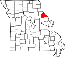 | |
| Villages | ||
| Townships |
| |
| CDPs | ||
| Unincorporated community | ||