Beltzville State Park
| Beltzville State Park | |
| Pennsylvania State Park | |
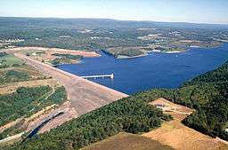 Beltzville Dam, impounding Beltzville Lake in Beltzville State Park | |
| Named for: the village of Beltzville | |
| Country | United States |
|---|---|
| State | Pennsylvania |
| County | Carbon |
| Townships | Franklin, Towamensing |
| Elevation | 633 ft (192.9 m) [1] |
| Coordinates | 40°52′06″N 75°36′29″W / 40.86833°N 75.60806°WCoordinates: 40°52′06″N 75°36′29″W / 40.86833°N 75.60806°W |
| Area | 2,972.39 acres (1,203 ha) |
| - water | 951.5 acres (385 ha) |
| Founded | 1972 |
| Management | Pennsylvania Department of Conservation and Natural Resources |
| IUCN category | V[2] |
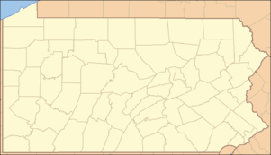 Location of Beltzville State Park in Pennsylvania
| |
| Website: Beltzville State Park | |
Beltzville State Park is a 2,972.39-acre (1,202.88 ha) Pennsylvania state park in Franklin and Towamensing townships, Carbon County, Pennsylvania in the United States. The park opened in 1972, and was developed around the U.S. Army Corps of Engineers flood control project, Beltzville Dam on Pohopoco Creek. The village of Big Creek Valley was vacated in 1966 to make way for Beltzville Lake.[3] Beltzville Lake is a 951.5 acres (385.1 ha) with 19.8 miles (31.9 km) of shoreline. Beltzville State Park is 5 miles (8.0 km) east of Lehighton just off U.S. Route 209. The park is at an elevation of 633 feet (193 m).[1]
Beltzville Lake is a popular fishing destination. Anglers can fish for striped bass, largemouth and smallmouth bass, trout, walleye, perch, and muskellunge. Pohopoco Creek is stocked with trout by the Pennsylvania Fish and Boat Commission.[4]
Hunting is permitted at Beltzville State Park. Hunters are expected to follow the rules and regulations of the Pennsylvania Game Commission. The common game species are ruffed grouse, squirrels, pheasant, waterfowl, white-tailed deer, and rabbits. The hunting of groundhogs is prohibited.[4]
The swimming beach is open from late May until the middle of September along 525 feet (160 m) of sand beach. There is a bathhouse with showers, a food stand, and first-aid building at the beach. Recreational scuba diving is prohibited at Beltzville State Park.[4]
Beltzville State Park has four picnic pavilions and several large picnic areas. Playgrounds and playfields are in the area of the picnic tables. Visitors also have the use of modern restrooms and drinking water. A large parking lot and a boat dock are also close by the picnic areas.[4]
There are 15 miles (24 km) of hiking trails at Beltzville State Park. The trails follow old roads, paths in the woods and follow the banks of small streams. Saw Mill Trail starts just west of Beltzville Dam is a path through the history of the park. Hikers will pass the remains of a gristmill, small ponds, an abandoned slate quarry and a wetland.[4]
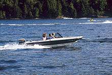
Beltzville Lake is popular with recreational boaters. The maximum boating speed permitted is 45 miles per hour (72 km/h). Boats with inboard engines with out-of-the-transom or straight stack type exhausts are prohibited. Camping overnight on boats is also prohibited. Canoes and other small boats are often seen in the shelter coves of Beltzville Lake.[4]
Water skiing is permitted only in the south end of the lake in the marked water skiing area. Boats are required to travel in a counterclockwise direction. Boats not towing water skiers or tubers are not permitted to enter the waters of the skiing area.[4]
Beltzville State Park does not close for the winter months, when Beltzville Lake is busy with ice fishing and ice boating. The trails of the park are open for cross-country skiing.[4]
Nearby state parks
The following state parks are within 30 miles (48 km) of Beltzville State Park:[5][6][7]
- Big Pocono State Park (Monroe County)
- Delaware Canal State Park (Bucks and Northampton Counties)
- Gouldsboro State Park (Monroe and Wayne Counties)
- Hickory Run State Park (Carbon County)
- Jacobsburg Environmental Education Center (Northampton County)
- Lehigh Gorge State Park (Carbon and Luzerne Counties)
- Locust Lake State Park (Schuylkill County)
- Nescopeck State Park (Luzerne County)
- Tobyhanna State Park (Monroe and Wayne Counties)
- Tuscarora State Park (Schuylkill County)
References
- 1 2 "Beltzville State Park". Geographic Names Information System. United States Geological Survey. August 30, 1990. Retrieved April 2, 2008.
- ↑ "Beltzville State Park". Protected Planet. Retrieved 13 January 2015.
- ↑ "Big Creek Valley before Beltzville Lake". Times News. Pencor Services, Inc. May 4, 2013. Retrieved 28 April 2014.
- 1 2 3 4 5 6 7 8 "Beltzville State Park". Pennsylvania Department of Conservation and Natural Resources. Retrieved November 11, 2005.
- ↑ 2007 General Highway Map Carbon County Pennsylvania (PDF) (Map). 1:65,000. Pennsylvania Department of Transportation, Bureau of Planning and Research, Geographic Information Division. Retrieved July 27, 2007. Note: shows Beltzville State Park
- ↑ Michels, Chris (1997). "Latitude/Longitude Distance Calculation". Northern Arizona University. Archived from the original on 11 April 2008. Retrieved April 20, 2008.
- ↑ "Find a Park by Region (interactive map)". Pennsylvania Department of Conservation and Natural Resources. Retrieved November 18, 2011.
External links
| Wikimedia Commons has media related to Beltzville State Park. |
- "Beltzville State Park official map" (PDF). (1159 KB)