Hickory Run State Park
| Hickory Run State Park | |
|---|---|
| Pennsylvania State Park | |
| Natural Monument (IUCN III) | |
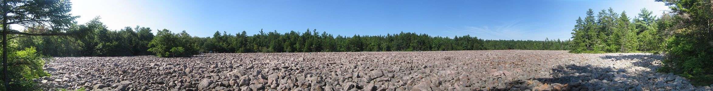
 Boulder Field at Hickory Run State Park, with people in the distance for scale | |
| Named for: Hickory Run | |
| Country | United States |
| State | Pennsylvania |
| County | Carbon |
| Townships | Kidder, Penn Forest |
| Location | [1] |
| - coordinates | 41°02′10″N 75°41′02″W / 41.03611°N 75.68389°WCoordinates: 41°02′10″N 75°41′02″W / 41.03611°N 75.68389°W |
| - elevation | 1,647 ft (502.0 m) [1] |
| Area | 15,990 acres (6,471 ha) |
| Founded | 1945 |
| Managed by | Pennsylvania Department of Conservation and Natural Resources |
 Location of Hickory Run State Park in Pennsylvania | |
| Website : Hickory Run State Park | |
Hickory Run State Park is a 15,990-acre (6,471 ha) Pennsylvania state park in Kidder and Penn Forest Townships in Carbon County, Pennsylvania in the United States. The park is spread across the Pocono Mountains. The park is easily accessible from Interstate 476 and Interstate 80.
Hickory Run State Park was chosen by the Pennsylvania Department of Conservation and Natural Resources (DCNR) and its Bureau of Parks as one of "25 Must-See Pennsylvania State Parks".[2]
Recreation
The park supports many activities, some of which vary seasonally. During the summer months, swimming is available in Sand Spring Lake, which is partially bordered by a sand beach. Beginning in 2008, lifeguards will not be posted at the beach.[3] In winter, the frozen lake can be used for ice skating. Seasonal hunting is permitted in many areas of the park, with white-tailed deer, black bear, and squirrels among the game that may be hunted legally. Additional hunting opportunities are available in nearby state game lands, some of which directly border the park.[4]
Geology
The most notable feature of Hickory Run State Park is the huge boulder field located in the northeast corner of the park.[5] The boulder field can be reached by car on Boulder Field Road or by hiking the 3.5-mile (5.6 km) long Boulder Field Trail from the trailhead on SR 534. The field comprises about 720,000 square feet (67,000 m2) (16.5 acres (6.7 ha) or 0.026 square miles (0.067 km2)) in area (1,800 feet (550 m) east-west by 400 feet (120 m) north-south). The top of the boulder layer is virtually level with the approaching path. The immense weight of the boulders has compressed the underlying soil 12 feet (3.7 m) or more. The boulder field was created about 20,000 years ago during the most recent glacial period. The boulders consist of the sandstone and conglomerates identical to those capping the ridges that surround the field on three sides (the Mississippian Pocono Formation). The creation of the boulder field was by the continual freeze thaw process in the ridges southwest of the field. As the ridges broke apart into angular boulders, they accumulated on clays, sands, and ice at the base of the ridges. During summer months, the ice in the mass would melt and carry the boulders and finer sediment down the valley to the location of the boulder field today. As the glaciers receded and melted, the drainage flowed through the field and took the sand and clays with it, leaving behind the stack of boulders. This process occurred several times over the thousands of years of glacial melt, which is why the field is so large. Many visitors cannot resist hopping from boulder to boulder across the field. This unique geological landscape is a National Natural Landmark.[4]
Hiking
The park contains 44 miles (71 km)[4] of trails that offer a variety of hiking experiences. For example, the 1.5-mile (2.4 km) long “Shades of Death” Trail follows the course of Sand Spring Run through dense rhododendron bushes that bloom from mid-June through mid-July. The run is dammed at certain points, creating scenic lakes. The Fireline, Gould, and Pine Hill Trails are suitable for cross-country skiing in winter. A short 0.7-mile (1.1 km) walk on the Hawk Falls trail leads to a popular waterfall.[4] Biking is prohibited on all trails.
-
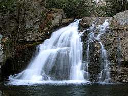
Hawk Falls
-
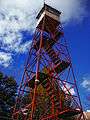
Stony Point Fire Tower
-
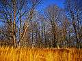
After the leaves fall
Nearby state parks
The following state parks are within 30 miles (48 km) of Hickory Run State Park:[6][7][8]
- Beltzville State Park (Carbon County)
- Big Pocono State Park (Monroe County)
- Frances Slocum State Park (Luzerne County)
- Gouldsboro State Park (Monroe and Wayne Counties)
- Jacobsburg Environmental Education Center (Northampton County)
- Lehigh Gorge State Park (Carbon and Luzerne Counties)
- Locust Lake State Park (Schuylkill County)
- Nescopeck State Park (Luzerne County)
- Tobyhanna State Park (Monroe and Wayne Counties)
- Tuscarora State Park (Schuylkill County)
References
- 1 2 "Hickory Run State Park". Geographic Names Information System. United States Geological Survey. August 2, 1979. Retrieved 2008-03-08.
- ↑ "Find a Park: 25 Must-see Parks". Pennsylvania Department of Conservation and Natural Resources. Retrieved May 26, 2015.
- ↑ "Pa. state parks going without life guards at beaches in 2008". The Times Leader. Retrieved 2008-02-16.
- 1 2 3 4 "Hickory Run State Park". Pennsylvania Department of Conservation and Natural Resources. Retrieved 2007-03-26.
- ↑ https://maps.google.com/maps?t=h&q=41.036111,-75.683889&ie=UTF8&hl=en&sll=41.043239,-75.679665&sspn=0.001580,0.003433&ei=S740SpfcJIfSNYCo7KAO&ll=41.050517,-75.642291&spn=0.00316,0.006866&z=18
- ↑ 2007 General Highway Map Carbon County Pennsylvania (PDF) (Map). 1:65,000. Pennsylvania Department of Transportation, Bureau of Planning and Research, Geographic Information Division. Retrieved 2007-07-27. Note: shows Hickory Run State Park
- ↑ Michels, Chris (1997). "Latitude/Longitude Distance Calculation". Northern Arizona University. Retrieved 2008-04-20.
- ↑ "Find a Park by Region (interactive map)". Pennsylvania Department of Conservation and Natural Resources. Retrieved November 18, 2011.
External links
| Wikimedia Commons has media related to Hickory Run State Park. |
- "Hickory Run State Park official map" (PDF). (1200 KB)